Advanced Storm Observation Project for Weather Forecasting
Explore the proposal for the TROPICS project featuring small satellites to enhance precipitation and storm intensity observations. The project aims to improve tropical cyclone forecasting through high-resolution data collection and simulation experiments. Discover the framework, domains, and control aspects involved in predicting tropical cyclone track and intensity changes using cutting-edge technology.

Download Presentation

Please find below an Image/Link to download the presentation.
The content on the website is provided AS IS for your information and personal use only. It may not be sold, licensed, or shared on other websites without obtaining consent from the author. If you encounter any issues during the download, it is possible that the publisher has removed the file from their server.
You are allowed to download the files provided on this website for personal or commercial use, subject to the condition that they are used lawfully. All files are the property of their respective owners.
The content on the website is provided AS IS for your information and personal use only. It may not be sold, licensed, or shared on other websites without obtaining consent from the author.
E N D
Presentation Transcript
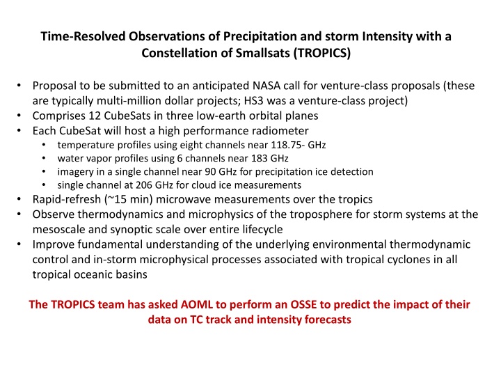
Time-Resolved Observations of Precipitation and storm Intensity with a Constellation of Smallsats (TROPICS) Proposal to be submitted to an anticipated NASA call for venture-class proposals (these are typically multi-million dollar projects; HS3 was a venture-class project) Comprises 12 CubeSats in three low-earth orbital planes Each CubeSat will host a high performance radiometer temperature profiles using eight channels near 118.75- GHz water vapor profiles using 6 channels near 183 GHz imagery in a single channel near 90 GHz for precipitation ice detection single channel at 206 GHz for cloud ice measurements Rapid-refresh (~15 min) microwave measurements over the tropics Observe thermodynamics and microphysics of the troposphere for storm systems at the mesoscale and synoptic scale over entire lifecycle Improve fundamental understanding of the underlying environmental thermodynamic control and in-storm microphysical processes associated with tropical cyclones in all tropical oceanic basins The TROPICS team has asked AOML to perform an OSSE to predict the impact of their data on TC track and intensity forecasts
OSSE Framework The regional OSSE (Observing System Simulation Experiment) framework described here features a high-resolution regional nature run embedded within a lower-resolution global nature run. Simulated observations are generated and provided to a data assimilation scheme which provides analyses for a high-resolution regional forecast model. background GSI HWRF observation simulator WRF NATURE RUN ECMWF NATUR E RUN SYNTHETIC DATA ANALYSIS FORECASTS verification Nature Runs - ECMWF: low-resolution T511 (~40km) Joint OSSE Nature Run - WRF-ARW: high-resolution 27km regional domain with 9/3/1 km storm-following nests (v3.2.1) Data Assimilation Scheme - GSI: Gridpoint Statistical Interpolation. a standard 3D variational assimilation scheme. Analyses performed at 9km resolution. DA and model cycling performed every 6 hours, each run producing a 5-day forecast, for total of 16 cycles.
Four domains with different spatial and temporal resolutions D01: 27 km(240x160), 30 min D02: 9 km (120x120), 30 min D03: 3 km (240x240), 30 min D04: 1 km (480x480), 6 min TROPICS data location (res: 21 km) 0802 00z storm center at 17.5N 43.4W 3
Control Control, T Control, T,Q Control,Q
Control, T Control Control, Q Control, T,Q
What is next? TROPICS data location (res: 21 km) 0803 00z storm center at 18.2N 46.5W Assimilate Tb Assimilate Data from D02 (~10x10)


