"Explore the latest advancements in geological surveys and geophysical acquisitions in Western Australia through the AusAEM program. Discover how these surveys provide valuable insights for mineral exploration, water resource management, and land use planning across the continent. Follow the timeline of planning, preparation, and execution of the AusAEM20-WA project to understand its significance in creating a national conductivity map. Learn about the objectives, methods, and applications of the Australia's airborne electromagnetic continental-scale acquisition program. Dive into conductivity-resistivity values of rock materials and layered earth inversions to enhance your understanding of geoscience. Uncover how these surveys help in mapping regolith thickness, identifying regional variations in bedrock conductivity, and guiding mineral exploration projects towards sustainable resource development."
Please find below an Image/Link to download the presentation.
The content on the website is provided AS IS for your information and personal use only. It may not be sold, licensed, or shared on other websites without obtaining consent from the author. If you encounter any issues during the download, it is possible that the publisher has removed the file from their server.
You are allowed to download the files provided on this website for personal or commercial use, subject to the condition that they are used lawfully. All files are the property of their respective owners.
The content on the website is provided AS IS for your information and personal use only. It may not be sold, licensed, or shared on other websites without obtaining consent from the author.
E N D
Presentation Transcript
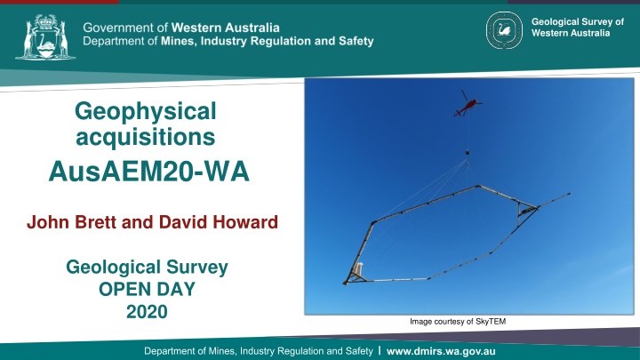
Geological Survey of Western Australia Geophysical acquisitions AusAEM20-WA John Brett and David Howard Geological Survey OPEN DAY 2020 Image courtesy of SkyTEM Government of Western Australia Department of Mines and Petroleum Government of Western Australia Department of Mines and Petroleum
AusAEM 67,000 line km 2017 - 2018 72,000 line km 2019 2020
AusAEM20 AusAEM20- -WA WA - - Objectives Objectives Provide explorers with insights into areas of thick cover and areas with potential targets for further investigation The data from these surveys will also assist in the production of a national conductivity map of Australia
AusAEM20 AusAEM20- -WA WA - - Planning and preparation Planning and preparation Jan 2020 Stakeholder Engagement Plan Mar 2020 Request for Quotation Apr 2020 Preferred respondent selected May 2020 Contract issued Jul 2020 Acquisition commences
to determine trends in regolith thickness to map regional variations in bedrock conductivity, within the depth of penetration of the system to set context for and guide mineral exploration project generation by industry to improve targeting for water resources definition as input for other land use applications in other industry sectors and land use agencies. "AusAEM: Australia s airborne electromagnetic continental-scale acquisition program Image courtesy of Geoscience Australia
Acquisition general planning criteria 1. Coverage before resolution Coverage Resolution trade-off For my limited money, do I want to know a lot about a little or a little about a lot? 2. Resolution Best affordable Factor of 4 improvement 3. Collaborate Increase coverage, resolution, methods Reduce cost High res small area Low res large area Equal cost surveys


![Project Initiation Document for [Insert.Project.name] [Insert.Project.number]](/thumb/226757/project-initiation-document-for-insert-project-name-insert-project-number.jpg)