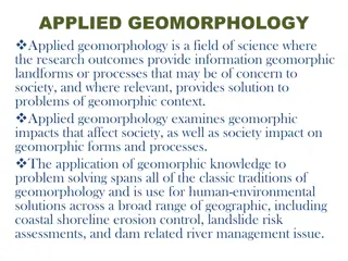
Applications of Applied Geomorphology in Environmental Studies
Geomorphology plays a crucial role in various fields such as soil erosion, beach engineering, and land classification. Its applications extend to mapping landforms, interpreting aerial photographs, monitoring environmental changes, and proposing remedies for unsustainable alterations. Understanding geomorphic processes is essential for mitigating human-induced impacts on landscapes.

Download Presentation

Please find below an Image/Link to download the presentation.
The content on the website is provided AS IS for your information and personal use only. It may not be sold, licensed, or shared on other websites without obtaining consent from the author. If you encounter any issues during the download, it is possible that the publisher has removed the file from their server.
You are allowed to download the files provided on this website for personal or commercial use, subject to the condition that they are used lawfully. All files are the property of their respective owners.
The content on the website is provided AS IS for your information and personal use only. It may not be sold, licensed, or shared on other websites without obtaining consent from the author.
E N D
Presentation Transcript
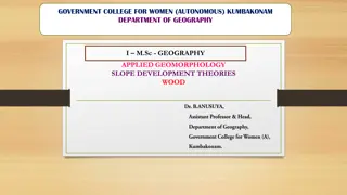
GOVERNMENT COLLEGE FOR WOMEN (AUTONOMOUS) KUMBAKONAM DEPARTMENT OF GEOGRAPHY I M.Sc - GEOGRAPHY APPLIED GEOMORPHOLOGY - UNIT:V APPLIED GMORPHOLGY - OTHER APPLICATIONS
UNIT: V UNIT: V APPLIED GEOMORPHOLOGY APPLIED GEOMORPHOLOGY - - P18GC101 APPLIED GEOMORPHOLOGY APPLIED GEOMORPHOLOGY OTHER APPLICATIONS OTHER APPLICATIONS P18GC101 Other Applications: The applications of geomorphic principles are most striking in the fields discussed above. But there are several other areas in which applied geomorphology is of use. As Thornbury points out, soil maps are to a considerable degree topographic maps, and the differentiation of the various members of any soil series rests fundamentally upon the different topographic conditions under which each member of the soil series developed. Modern beach engineering (M.A. Mason; W.C. Krumbein), to be successful, must be based upon an appreciation of the processes of shoreline development.
The problem of soil erosion (C.B. Brown; H.V. Peterson) is essentially a problem involving recognition and proper control of such geomorphic processes as sheet-wash erosion, gulleying, mass-wasting and stream erosion. The severity of erosion is not determined by the angle of slope alone. It may not be serious on steep slopes where those slopes are underlain by permeable materials, and it may be serious on slight slopes where they are on impermeable materials. The related problem of land classification also entails an appreciation of varying types of terrains and the best uses that may be made of them. Application of geomorphology can be of immense use in controlling the adverse effects of human activities on geomorphic forms and processes. Indeed, this field has also developed into a separate branch, anthrop geomorphology .
Technique of Applied Geomorphology: Applied geomorphology deals with the interactions of geomorphology with anthropogenic activities. So the basic aspects of applied geomorphology are as follows: 1. Mapping of landforms viz. slope elements which affect and/or modify human activity. 2. Attempting to interpret aerial photographs and images taken by remote sensing methods. 3. Monitoring the environmental changes, especially when such changes are not sustainable in nature. 4. Endeavouring to assess the causes of unsustainable changes. 5. Proposing remedies for hazards caused by unsustainable changes.
Interpretation of Aerial Photographs and Satellite Images: Preparation of specialised maps and interpreting them has become easier and accurate with the introduction of air photographs and satellite imageries. Air photographs (taken from aeroplanes) are taken on different scales and the distributional patterns of relevant features are transferred on the maps bearing the same scales to make them up-to-date. Nowadays, aerial photographs are being used for evaluating landforms and land use vis-a-vis city developmental plans, major construction projects, etc. Satellite imageries are useful for studying global and country-level climatic phenomena (weather forecasting has become more accurate with the introduction of meteorological data gathered by satellites) but these imageries are also of paramount importance in mineral prospecting, preparation of land use inventories and forecasting agricultural output etc.
Remote Sensing: Remote sensing deals with the collection of information regarding objects from a certain distance without coming into contact with them. An assembly of electro-optical devices called sensors as well as cameras measure spectral behaviour of objects under study. Nowadays, the most widely used remote sensing techniques are linked with the sensing of electromagnetic radiation emitted from the terrestrial objects. Different objects have different scattering properties called signatures owing to their different molecular composition. A thorough knowledge of signatures is vital for interpreting satellite images.
Importance of Remote Sensing Technique: Remote sensing is necessary for sustainable management of natural resources like soil, forest, crops, oceans, urban and town planning etc. Resource planners require such techniques for timely information on the condition and extent of resources. Since these resources are dynamic and replenishable in nature, the ground-based monitoring systems can hardly monitor the condition of these resources without a gap of days or weeks. Satellite-based surveys enjoy a definite advantage of repetitivity. These surveys are conducted from a height of 500-900 km above the surface. Nowadays Geographical Information Systems or GIS technology has been used along with remote sensing techniques. GIS may be defined as spatial, integrated data-handling programmes used to gather, store and retrieve spatial data from the real world. GIS contain selected data, only those properties geographical investors consider to be relevant. (Oxford Dictionary of Geography)
Remote Sensing Survey enjoys the following advantages over ground surveys: 1. Synoptic view or wide coverage of a large area is possible. 2. Permanent record of ground conditions is subject to verification later at any time. 3. Interpretation of remote sensing data requires much less time than do cumbersome ground surveys. 4. Remote sensing technique is capable of accessing thermal and microwave regions not accessible to the naked eye. 5. Ground surveys involve more time, money and infrastructure in comparison to remote sensing surveys.
6. Ground surveys, if repeated, are highly uneconomical. 7. The same remote sensing data is useful for different purposes; for example, the same data may be used by soil scientists for soil surveys, by geohydrologists for groundwater surveys or by agricultural scientists for crop surveys. 8. Remote sensing surveys are free from handicaps like bad weather conditions.
Thank you Thank you
 KUMBAKONAM")

 is")
 is")