Explore how remote sensing data can aid in understanding climate change impacts, future research needs, and the challenges and opportunities in utilizing such data for assessment purposes.
Please find below an Image/Link to download the presentation.
The content on the website is provided AS IS for your information and personal use only. It may not be sold, licensed, or shared on other websites without obtaining consent from the author. If you encounter any issues during the download, it is possible that the publisher has removed the file from their server.
You are allowed to download the files provided on this website for personal or commercial use, subject to the condition that they are used lawfully. All files are the property of their respective owners.
The content on the website is provided AS IS for your information and personal use only. It may not be sold, licensed, or shared on other websites without obtaining consent from the author.
E N D
Presentation Transcript
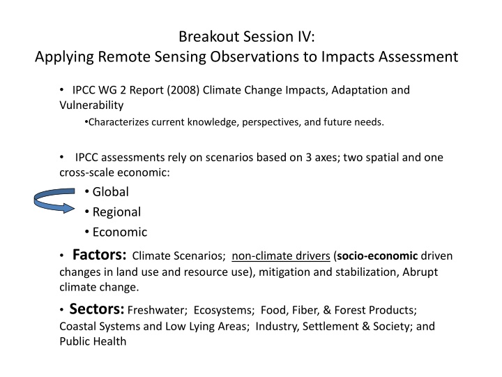
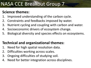
Breakout Session IV: Applying Remote Sensing Observations to Impacts Assessment IPCC WG 2 Report (2008) Climate Change Impacts, Adaptation and Vulnerability Characterizes current knowledge, perspectives, and future needs. cross-scale economic: Global Regional Economic IPCC assessments rely on scenarios based on 3 axes; two spatial and one Factors: Climate Scenarios; non-climate drivers (socio-economic driven changes in land use and resource use), mitigation and stabilization, Abrupt climate change. Sectors: Freshwater; Ecosystems; Food, Fiber, & Forest Products; Coastal Systems and Low Lying Areas; Industry, Settlement & Society; and Public Health
Breakout Session IV: Applying Remote Sensing Observations to Impacts Assessment IPCC WG2 Future Research Needs Climate Modeling that elucidates the nature of future changes at regional scale. Especially precipitation, hydrological consequences. Understanding regional effects of abrupt climate change events. Monitoring: Long-term field data collection on managed and un-managed systems and human activities. (Can remote sensing data augment this activity?) Ability to integrate multiple stressors for vulnerability assessment. Adaptation to environmental changes Costs of adaptation/mitigation
Breakout Session IV: Applying Remote Sensing Observations to Impact Assessment Remotely sensed observations should support efforts that bridge global and regional scales Climate modeling regional manifestation of changes Abrupt climate change scenarios regional manifestations. Long-term field data collection that includes managed and un-managed systems and human activities.
Breakout Session IV: Applying Remote Sensing Observations to Impacts Assessment Current missions provide a wide range of relevant data. Research should be steered to use these data in relevant regional scale modeling efforts. Spatial resolution: Are multi-kilometer scale, 1km, 500m, 250m resolutions adequate? Cross-platform data integration needed (including non-NASA data) to link processes. What platforms/sensors should be grouped?
Questions to be addressed What research can we conduct to better address the impacts and consequences of global change? What actions would be most useful to or supportive of future assessments? What are the greatest challenges and opportunities relevant to the use of remote sensing data for impacts assessment?
Breakout Session IV: Applying Remote Sensing Observations to Impacts Assessment Current NASA Missions Terra Aqua Aura TRMM ICESAT QUICKSCAT Calipso Cloudsat GRACE JASON EO-1