Assessing Climate Change Impact on Koshi River Basin
In this project led by Dr. Laxmi Devkota, the team aims to evaluate the effects of climate change on water resources in the Koshi River Basin. With a focus on flood risks and stakeholder awareness, the research methodology involves hydro-meteorological analysis and hydrologic modeling. The initiative seeks to inform policy formulation and community engagement while advancing knowledge on climate change impacts.

Download Presentation

Please find below an Image/Link to download the presentation.
The content on the website is provided AS IS for your information and personal use only. It may not be sold, licensed, or shared on other websites without obtaining consent from the author. If you encounter any issues during the download, it is possible that the publisher has removed the file from their server.
You are allowed to download the files provided on this website for personal or commercial use, subject to the condition that they are used lawfully. All files are the property of their respective owners.
The content on the website is provided AS IS for your information and personal use only. It may not be sold, licensed, or shared on other websites without obtaining consent from the author.
E N D
Presentation Transcript
Laxmi Devkota Principal Investigator NDRI
Project Brief Funded by: Climate and Development Knowledge Network (CDKN) and Global Change SysTem for Analysis, Research and Training (START) Team: PI: Dr. Laxmi Devkota CI: Dr. Manjeshowri Singh CI: Dr. Sunil Babu Shrestha CI: Dr. Rijan B. Kayastha RA: Research Students: 3 Persons 5 Persons Steering Committee: To Guide the Team
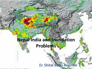
Introduction: Koshi River Basin Koshi River : One of the largest tributaries of the Ganges River System Trans-boundary river: China, Nepal and India Drains 29,400 km2 in China and 30,700 km2 in Nepal (ICIMOD, 2008)
Introduction: Koshi River Basin South-west monsoon greatly influences the hydrology of the Koshi River Basin High sediment laden river Shifting nature of main river course Flooding incidences Glacial Lakes: 599, covering 26 sq. km. (ICIMOD, 2011)
Rationale Water induced disasters: Devastating Flood events: Recent 18thAugust 2008; 16 GLOF events Rapid development including urbanizations in the lower part of the basin: the communities and infrastructure more vulnerable to the increasing flood hazards including the risks of GLOFs Koshi High Dam: Flood control, Irrigation and Hydropower generation Climate Change: Impact the hydrological regime
Objectives of the Project Overall Objective: To assess the impact of climate change on current and future development in Koshi River Basin Specific objectives: Advancing knowledge on climate change impact on water resources Assessment of flood risks in the context of climate change Revisiting the design standards/values Contributing to policy formulation process Awareness building of stakeholders including local communities and training of new generation
Methodology Research Component Methodology 1. Advancing knowledge on climate change impact on water resources i. Hydro-meteorological Diagnostics Analysis of available historical data on climatological and hydrological variables for any trend and changes in its statistics ii. Hydrologic and Hydraulic Modeling a. Acquisition of data from suitable GCM/RCM models b. Development and Use of the Snow/ Glacier Melt Runoff Model c. Development and Use the Hydrologic (rainfall-runoff) Model d. Development and Use of Hydraulic Models
Modeling SN Activities Models 1 Climate Change Data Under Process (DHM is to release Data Portal on CC) WinSRM 2 Snow melt Runoff 3 Rainfall-Runoff SWAT 4 Sediment Yield SWAT 5 Inundation and Flood Analysis HEC-RAS
Methodology (contd.) Research Component Methodology 2. Revisiting the design standard / values of the infrastructure: the proposed Koshi High Dam Results of the hydrologic, hydraulic and sediment transport modeling will be used to a. Analyze the design parameters / values of the reservoir with climate change scenario: Capacity of Dam b. Access the climate change Risk: Dam breaking, Water availability
Design Values Vcc Without CC Estimation Volume of Sediment CC Estimation Vdesign Tcc Tdesign Year
Methodology (contd.) Research Component Methodology 3. Assessment of Socio-economic Vulnerability, Land Use and Exposure of critical infrastructures Risk = Hazard x Exposure x Vulnerability Hazard: Flood Hazard Map- Modeling Result Exposure: Population, Agricultural and Industrial Area Field Survey & Census Vulnerability : Demographic, economic and social characteristics & degree of preparedness and recovery capacity (Eidsvig, 2011)- Field Survey
Methodology (contd.) Research Component Methodology Research result dissemination workshops 4. Contributing to policy formulation process on climate resilient development Hazard, vulnerability and risk maps will be helpful to decide the planners to take decisions on land use management planning
Methodology (contd.) Research Component Methodology Series of stakeholders consultations and workshops 5. Awareness building to stakeholders including local communities and Training of new generation Two/Three full-time research associates and five master s level theses research
Outputs, Outcomes and Impacts Expected Impacts : Reduction on climate related disasters and losses in the Koshi River Basin Formulation of better policy related to DRR and CCA Specific Outputs: Models to assess the climate change impacts Hazard, Vulnerability and Risk Maps Policy recommendations at national and community levels for DRR and CCA Capacity building of young researchers Publication of peer-reviewed journal articles Awareness Buildings of the concerned stakeholders


")


")
")
")