Australia's Foundational Spatial Data Framework Overview
Covering Australia's distributed national spatial dataset production systems and community involvement, the Foundational Spatial Data Framework (FSDF) is a government initiative aimed at streamlining the production of national spatial data products. Coordinated by Geoscience Australia, FSDF plays a crucial role in enhancing accessibility and improving the overall production processes of spatial data.

Download Presentation

Please find below an Image/Link to download the presentation.
The content on the website is provided AS IS for your information and personal use only. It may not be sold, licensed, or shared on other websites without obtaining consent from the author.If you encounter any issues during the download, it is possible that the publisher has removed the file from their server.
You are allowed to download the files provided on this website for personal or commercial use, subject to the condition that they are used lawfully. All files are the property of their respective owners.
The content on the website is provided AS IS for your information and personal use only. It may not be sold, licensed, or shared on other websites without obtaining consent from the author.
E N D
Presentation Transcript
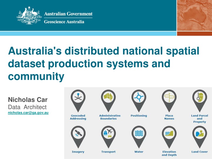
Australia's distributed national spatial dataset production systems and community Nicholas Car Data Architect nicholas.car@ga.gov.au
Outline The Foundational Spatial Data Framework What it is - in outline What it is not W3C standards & models Linked Data use Spatial reference data Social architecture Australia's distributed national spatial dataset production systems and community
The Foundational Spatial Data Framework FSDF: a Federal and State government initiative to streamline the production of national spatial data products for the Dept. Prime Minster & Cabinet coordinated by Geoscience Australia Australia's distributed national spatial dataset production systems and community
The Foundational Spatial Data Framework FSDF: a Federal and State government initiative to streamline the production of national spatial data products for the Dept. Prime Minster & Cabinet coordinated by Geoscience Australia Are there legal mandates and funding sources for these? Australia's distributed national spatial dataset production systems and community
The Foundational Spatial Data Framework FSDF: a Federal and State government initiative to streamline the production of national spatial data products for the Dept. Prime Minster & Cabinet coordinated by Geoscience Australia Are these accessible generally? Australia's distributed national spatial dataset production systems and community
The Foundational Spatial Data Framework FSDF: a Federal and State government initiative to streamline the production of national spatial data products for the Dept. Prime Minster & Cabinet coordinated by Geoscience Australia Can we process improve the production of these? Australia's distributed national spatial dataset production systems and community
The Foundational Spatial Data Framework FSDF: a Federal and State government initiative to streamline the production of national spatial data products for the Dept. Prime Minster & Cabinet coordinated by Geoscience Australia Can we trace the provenance of these? Australia's distributed national spatial dataset production systems and community
The Foundational Spatial Data Framework What the FSDF is not: An awesome tool Not smart , machine learning etc. A fast, non-permanent initiative Started in 2012 Run by one agency Going to achieve success through one channel Australia's distributed national spatial dataset production systems and community
Use of W3C standards & models Provenance: Granularity 1: National Dataset level Dataset level Input Dataset 1 wasDerivedFrom Output Dataset A Input Dataset 2 National Dataset X Output Dataset B Input Dataset 3 Australia's distributed national spatial dataset production systems and community
Use of W3C standards & models Provenance: Granularity 2: Output Dataset Components Feature / Component level wasDerivedFrom Input Dataset 1 Output Dataset A Input Dataset 2 Input Dataset 3 Australia's distributed national spatial dataset production systems and community
Use of W3C standards & models Provenance: Granularity 3: National Dataset fabric Feature / Component level with reference datasets Input Dataset 1 Dataset 1 Dataset 3 Input Input wasDerivedFrom Output Dataset A Input Dataset 2 Dataset 2 Dataset 6 Input Input The National Dataset Output Dataset B Input Dataset 3 Dataset 3 Dataset 9 Input Input Australia's distributed national spatial dataset production systems and community
Use of W3C standards & models Granularity 1: National Dataset level, work to date FSDF Ontology DCAT PROV ORG Australia's distributed national spatial dataset production systems and community
Use of W3C standards & models Granularity 2: Output Dataset components, next FY + 3 FSDF Ontology QB4ST DCAT PROV ORG Australia's distributed national spatial dataset production systems and community
Use of W3C standards & models Granularity 3: National Dataset fabric, start 3+ years away FSDF Ontology QB4ST DCAT TIME PROV ORG Lots of Vocs SSN Australia's distributed national spatial dataset production systems and community
Linked Data use Currently, datasets, if available online, are in GeoNetwork or CKAN catalogues Australia's distributed national spatial dataset production systems and community
Linked Data use Currently, datasets, if available online, are in GeoNetwork or CKAN catalogues Realistically, no semantics of value beyond DCAT Students working on a baseline now Australia's distributed national spatial dataset production systems and community
Linked Data use Currently, datasets, if available online, are in GeoNetwork or CKAN catalogues Government metrics/requirements bound to ISO19* Australia's distributed national spatial dataset production systems and community
Linked Data use Currently, datasets, if available online, are in GeoNetwork or CKAN catalogues Government metrics/requirements bound to ISO19* Linked Data API will be used for increasing semantics while preserving backwards-compatibility Australia's distributed national spatial dataset production systems and community
Linked Data use Linked Data API will be used for increasing semantics while preserving backwards-compatibility eCat example: ISO19115 XML GeoNetwork normal ISO19115-derived HTML Dataset Australia's distributed national spatial dataset production systems and community
Linked Data use Linked Data API will be used for increasing semantics while preserving backwards-compatibility eCat example: ISO19115 XML ISO19115-derived HTML Dataset Limited DCAT RDF Australia's distributed national spatial dataset production systems and community
Linked Data use Linked Data API will be used for increasing semantics while preserving backwards-compatibility eCat example: ISO19115 XML Schema.org ISO19115-derived HTML Dataset Limited DCAT RDF Australia's distributed national spatial dataset production systems and community
Linked Data use Linked Data API will be used for increasing semantics while preserving backwards-compatibility eCat example: ISO19115-1 XML Enhanced! Schema.org ISO19115-derived HTML Dataset Limited DCAT RDF Australia's distributed national spatial dataset production systems and community
Linked Data use Linked Data API will be used for increasing semantics while preserving backwards-compatibility eCat example: FSDF Ont ISO19115-1 XML Enhanced! Schema.org ISO19115-derived HTML Dataset Limited DCAT RDF Australia's distributed national spatial dataset production systems and community
Linked Data use Linked Data API will be used for increasing semantics while preserving backwards-compatibility eCat example: FSDF Ont ? ISO19115-1 XML Enhanced! Schema.org ISO19115-derived HTML Dataset Limited DCAT RDF Australia's distributed national spatial dataset production systems and community
Spatial Reference Data We need reference semantic data, not just models Common Subjects P O to associate facts with The Geofabric was the first attempt Known relationships in separate graphs not enough Australia's distributed national spatial dataset production systems and community
Spatial Reference Data We need reference semantic data, not just models Common Subjects P O to associate facts with The Geofabric was the first attempt Need common nodes Australia's distributed national spatial dataset production systems and community
Spatial Reference Data We need reference semantic data, not just models Common Subjects P O to associate facts with The Geofabric was the first attempt Mothballed due to lack of sophisticated users Australia's distributed national spatial dataset production systems and community
Spatial Reference Data We need reference semantic data, not just models Common Subjects P O to associate facts with The Geofabric was the first attempt Let s aim simpler: Admin boundaries Far fewer difficult spatial elements Far more popular Australia's distributed national spatial dataset production systems and community
Spatial Reference Data We need reference semantic data, not just models Common Subjects P O to associate facts with The Geofabric was the first attempt Let s aim simpler: Admin boundaries Organisations Non-spatial but most common dataset Works in Sem Web + Legacy systems Australia's distributed national spatial dataset production systems and community
Social Architecture is paramount We need coordination As the FSDF is providing spatial Australia's distributed national spatial dataset production systems and community
Social Architecture is paramount We need coordination As the FSDF is providing spatial More general LD support needed New/hard for agencies AGLDWG Australia's distributed national spatial dataset production systems and community
Australian Government Linked Data Working Group http://linked.data.gov.au | agldwg-all@lists.csiro.au About Government experts and champions. It draft policy and technical guidance on the implementation Linked Data for the Australian Government. Open Federal entities and friends. Linked Data Solutions of to all Recomm- endations Subgroups Visibility What is Linked Data?
Australian Government Linked Data Working Group http://linked.data.gov.au | agldwg-all@lists.csiro.au About Government experts and champions. It draft policy and technical guidance on the implementation Linked Data for the Australian Government. Open Federal entities and friends. Linked Data Solutions of to all Members Australian Bureau of Statistics Australian National University (Chair) Bureau of Meteorology CSIRO Dept. of Communications Dept. of Finance Dept. of Human Services Dept. of the Prime Minister and Cabinet Geoscience Australia National Archives of Australia Recomm- endations Subgroups Visibility What is Linked Data? Informal Members National Computational Infrastructure Link Digital Intersect Australia PSMA
Australian Government Linked Data Working Group http://linked.data.gov.au | agldwg-all@lists.csiro.au About Government experts and champions. It draft policy and technical guidance on the implementation Linked Data for the Australian Government. Open Federal entities and friends. Linked Data Solutions All of Govt. LD tooling of to all Members Australian Bureau of Statistics Australian National University (Chair) Bureau of Meteorology CSIRO Dept. of Communications Dept. of Finance Dept. of Human Services Dept. of the Prime Minister and Cabinet Geoscience Australia National Archives of Australia Recomm- endations How to make Linked Data Subgroups (those that do things) Visibility What is Linked Data? Informal Members National Computational Infrastructure Link Digital Intersect Australia PSMA Organising the Aust. LD community
Australian Government Linked Data Working Group http://linked.data.gov.au | agldwg-all@lists.csiro.au About Government experts and champions. It draft policy and technical guidance on the implementation Linked Data for the Australian Government. Open Federal entities and friends. Linked Data Solutions All of Govt. LD tooling of to all Members Australian Bureau of Statistics Australian National University (Chair) Bureau of Meteorology CSIRO Dept. of Communications Dept. of Finance Dept. of Human Services Dept. of the Prime Minister and Cabinet Geoscience Australia National Archives of Australia Recomm- endations How to make Linked Data Subgroups (those that do things) Visibility What is Linked Data? Informal Members National Computational Infrastructure Link Digital Intersect Australia PSMA Organising the Aust. LD community
Social Architecture is paramount We need coordination As the FSDF is providing spatial More general LD support needed LD Funding and policy drivers Australia's distributed national spatial dataset production systems and community
Social Architecture is paramount We need coordination As the FSDF is providing spatial More general LD support needed LD Funding and policy drivers A role for the proposed National Data Custodian? Australia's distributed national spatial dataset production systems and community
Social Architecture is paramount We need coordination As the FSDF is providing spatial More general LD support needed LD Funding and policy drivers Communities of Practice to evolve legacy systems GeoNetworks CKAN Vocabularies Old spatial standards Australia's distributed national spatial dataset production systems and community
Social Architecture is paramount We need coordination As the FSDF is providing spatial More general LD support needed LD Funding and policy drivers Communities of Practice to evolve legacy systems Flagship products Overcome the Geofabric hump! Broad: the whole FSDF Deep: a specific FSDF product Australia's distributed national spatial dataset production systems and community
Nicholas Car Data Architect nicholas.car@ga.gov.au FSDF http://fsdf.org/LINK Geoscience Australia http://www.ga.gov.au Aust. Gov. Linked Data WG http://linked.data.gov.au