Berkeley County Proposed Shelter Model and Displacement Assessment Records
Explore the proposed shelter model and displacement assessment records in Berkeley County, focusing on population displacement due to flood events. Understand the calculations and data extraction methods employed at both building and community levels to estimate displaced individuals and residential units. Discover the defined equation to quantify the impact of inundation with depths of 1 foot or more, aiding in short-term shelter needs planning.

Download Presentation

Please find below an Image/Link to download the presentation.
The content on the website is provided AS IS for your information and personal use only. It may not be sold, licensed, or shared on other websites without obtaining consent from the author. If you encounter any issues during the download, it is possible that the publisher has removed the file from their server.
You are allowed to download the files provided on this website for personal or commercial use, subject to the condition that they are used lawfully. All files are the property of their respective owners.
The content on the website is provided AS IS for your information and personal use only. It may not be sold, licensed, or shared on other websites without obtaining consent from the author.
E N D
Presentation Transcript
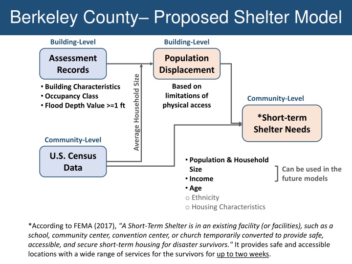
Berkeley County Proposed Shelter Model Building-Level Building-Level Assessment Records Population Displacement Average Household Size Building Characteristics Occupancy Class Flood Depth Value >=1 ft Based on limitations of physical access Community-Level *Short-term Shelter Needs Community-Level U.S. Census Data Population & Household Size Income Age o Ethnicity o Housing Characteristics Can be used in the future models *According to FEMA (2017), "A Short-Term Shelter is in an existing facility (or facilities), such as a school, community center, convention center, or church temporarily converted to provide safe, accessible, and secure short-term housing for disaster survivors." It provides safe and accessible locations with a wide range of services for the survivors for up to two weeks.
Berkeley County Displacement BASE MODEL: Flood Model Hazus-MH Technical Manual MODIFICATIONS: Scale of calculations changed to buildings Hazard Occupancy Code and Flood Depth Value from assessment data of Berkeley County at the scale of buildings (Building Inventory) Average Household Size of the communities from census data (2017 American Community Survey (ACS) 5-Year Estimates downloaded from "American Fact Finder ) DATA: Extraction of the buildings located in flood zones with the depth value of 1 ft or more Estimating the number of the residential units in each building using the occupancy code Calculation of the estimated residing population in each building using the average household size of the community Adding the population of the buildings in each community METHOD:
Berkeley County Displacement DEFINED EQUATION: ? #????= (????????? ?????????????) ?=? Where: #DIIN = the number of displaced individuals as a result of inundation with the depth equal or more than 1 foot ResUNITIN= the number of residential units in each building located within the area of inundation with the depth equal or more than 1 foot AveHHSizeCOMM= the average household size of the community where the building is located j= the number of residential buildings within the flooded area with the depth equal or more than 1 foot A part of the population displacement table at building level
Berkeley County Shelter Needs BASE MODEL: Flood Model Hazus-MH Technical Manual MODIFICATIONS: Income classes updated based on the inflation rate Displaced Population estimated in the previous part Household Income and Age from census data (2017 American Community Survey (ACS) 5-Year Estimates downloaded from "American Fact Finder ) DATA: METHOD: Based on "Flood Model Hazus-MH Technical Manual", Chapter 13, at the scale of communities: Calculation of the percentage of households in the income classes: - IM1: HH Income per year < $20,000 - IM2: $20,000 <= HH Income per year < $30,000 - IM3: $30,000 <= HH Income per year < $50,000 - IM4: $50,000 <= HH Income per year < $60,000 - IM5: $60,000 <= HH Income per year Calculation of the percentage of individuals in the age classes: - AM1: Less than 15 years - AM2: 15 to 64 years - AM3: 65 years or more
Berkeley County Shelter Needs MODIFICATIONS TO INCOME CLASSES: The inflation rate of 1990 to 2017 (1.87) was slightly changed while applying to make the intervals match the census data Income Class Original and Hazus Models Modified Model IM1 HH Income < $10,000 HH Income < $20,000 IM2 $10,000 <= HH Income < $15,000 $20,000 <= HH Income < $30,000 IM3 $15,000 <= HH Income < $25,000 $30,000 <= HH Income < $50,000 IM4 $25,000 <= HH Income < $35,000 $50,000 <= HH Income < $60,000 IM5 $35,000 <= HH Income $60,000 <= HH Income
Berkeley County Shelter Needs USED EQUATIONS: ? ? #??? = ??? ?? ??? ??? Where: ?=? ?=? #STP = Number of people using established shelters km= a constant calculated as below DP= Displaced population by inundation with equal or more than 1 foot depth (from the previous stage) HIk= Percentage of population in the kth income class HAm= Percentage of population in mth age class ) ???= (?? ???) + (?? ??? Where: IW= Shelter category weight for income (0.8) AW= Shelter category weight for age (0.2) IMk= Relative modification factor for income (calculated using table 13.2 in the manual) AMm= Relative modification factor for age (calculated using table 13.2 in the manual)
Berkeley County Results MAP- Estimated Displaced Population in a 100-year Flood, Berkeley County MAP- Estimated Shelter Needs in a 100- year Flood, Berkeley County
Berkeley County Results Displaced People and Shelter Needs in Berkeley County 800 700 600 Number of people 500 400 300 200 100 0 1 2 Unincorporated Area Martinsburg Estimated Population in Need of Short Term Shelter Displaced Population Average Residential Household Size Population Residing in High Risk Flood Zone Percentage of Population Residing in High Risk Flood Zone Number of Households with inundation water depth >= 1 foot Percentage of Population in Flood Zones Displaced Estimated Population in Need of Short Term Shelter Percentage of Population in Flood Zones in Need of Shelter Total Companion Dogs Shelter Need Companion Cats Shelter Need Community Name Community Type Displaced Population CID County Community Population Berkeley County* 540282 BERKELEY Unincorporated 93834 2.7 1719.9 2% 265 716 42% 106 6% 15 10 540006 Martinsburg BERKELEY Incorporated 17451 2.4 211.2 1% 36 87 41% 18 9% 3 2 Total in County - 111285 2.628 1931.1 2% 301 803 42% 124 6% 18 12
Future Directions Include more variables relevant to housing characteristics in the shelter model such as: o Housing Ownership Type (Owned or Rental) o Occupancy Type (Single family, Multi-family, & Mobile Home) o Geography: Urban versus Rural Research and review the actual shelter data of floods provided by the American Red Cross to test the model Data preparation for unincorporated areas missing in the census data by subtracting the demographic data of the communities from those of the county Automate data processing of the required variables for displacement and shelter estimations Customize Open Hazus FAST Flood Assessment Structure Tool including population displacement and shelter needs the task of estimating and preparing for shelter demand is still very challenging. (Dr. John Harrald, 2019) The results of all modeling efforts should be interpreted with a degree of skepticism. (Harrald et al., 1994, p.13) Any model is a selective representation of reality. (Harrald et al., 1994, p.14)