Catalogue of Data and Web Processing Services
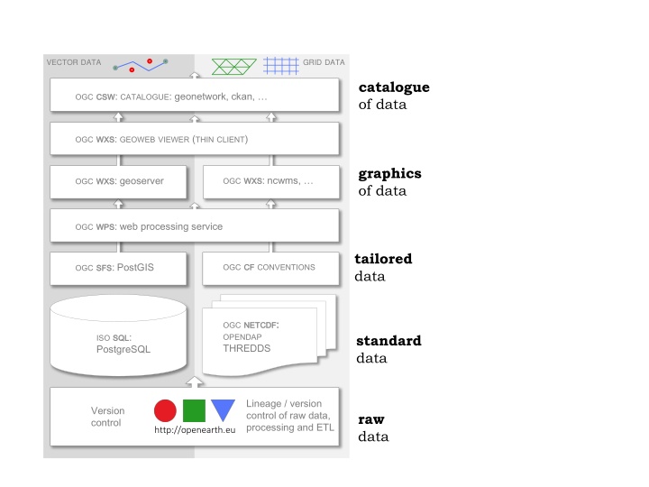
Comprehensive catalogue of data sources and web processing services tailored for efficient data retrieval, visualization, and processing. Access processed data, images, and information seamlessly with standardized conventions and version control. Utilize PostgreSQL, PostGIS, and other tools for data management. Follow a clear roadmap for data development, with operational support through GIT. Discover, view, and download data effortlessly through various web viewers and services

Download Presentation

Please find below an Image/Link to download the presentation.
The content on the website is provided AS IS for your information and personal use only. It may not be sold, licensed, or shared on other websites without obtaining consent from the author.If you encounter any issues during the download, it is possible that the publisher has removed the file from their server.
You are allowed to download the files provided on this website for personal or commercial use, subject to the condition that they are used lawfully. All files are the property of their respective owners.
The content on the website is provided AS IS for your information and personal use only. It may not be sold, licensed, or shared on other websites without obtaining consent from the author.
E N D
Presentation Transcript
VECTORDATA GRIDDATA catalogue of data OGCCSW CSW: CATALOGUE: geonetwork, ckan, OGCWXS WXS: GEOWEBVIEWER (THINCLIENT) graphics of data OGCWXS WXS: ncwms, OGCWXS WXS: geoserver OGCWPS WPS: web processing service tailored data OGCCF CFCONVENTIONS OGCSFS SFS: PostGIS OGCNETCDF OPENDAP THREDDS NETCDF: : ISOSQL PostgreSQL SQL: standard data Lineage / version control of raw data, processing and ETL Version control raw data http://openearth.eu
VECTORDATA GRIDDATA catalogue of data OGCCSW CSW: CATALOGUE: geonetwork, ckan, OGCWXS WXS: OTSWEBVIEWER (THINCLIENT) graphics of data OGCWXS WXS: ncwms, OGCWXS WXS: geoserver OGCWPS WPS: web processing service tailored data OGCSFS SFS: postgis OGCCF CFCONVENTIONS OGCNETCDF OPENDAP thredds NETCDF: : ISOSQL postgresql SQL: standard data LEGEND: SubVersion Lineage / version control of raw data, processing and ETL ROADMAP raw data DEVELOPMENT GIT OPERATIONAL
discover, view and download of data OGCWXS VIEWER (THINCLIENT) WXS: OTSWEB OGCCSW geonetwork, ckan, CSW: CATALOGUE: VECTORDATA GRIDDATA information Processed data or images OGCWXS ncwms, WXS: OGCWXS geoserver WXS: OGCWPS WPS: tailored data OGCSFS SFS: postgis OGCCF CFCONVENTIONS standard data OGCNETCDF OPENDAP thredds NETCDF: : ISOSQL postgresql SQL: LEGEND: SubVersion Lineage / version control of raw data, processing and ETL raw data ROADMAP DEVELOPMENT GIT OPERATIONAL