Explore different types of clouds with images and clues such as altostratus, stratocumulus, nimbostratus, cirrostratus, cumulus, and more to enhance your understanding of weather patterns and forecasting.
Please find below an Image/Link to download the presentation.
The content on the website is provided AS IS for your information and personal use only. It may not be sold, licensed, or shared on other websites without obtaining consent from the author. If you encounter any issues during the download, it is possible that the publisher has removed the file from their server.
You are allowed to download the files provided on this website for personal or commercial use, subject to the condition that they are used lawfully. All files are the property of their respective owners.
The content on the website is provided AS IS for your information and personal use only. It may not be sold, licensed, or shared on other websites without obtaining consent from the author.
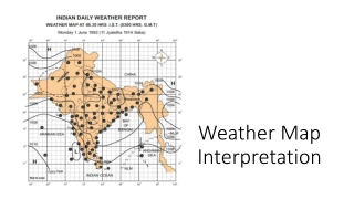
Weather Maps Weather Maps are absolutely critical for forecasters. They contain information regarding fronts, highs and lows, isobars, and weather data for specific locations expressed through the use of symbols.
Isobars Air pressure is shown on a weather map using isobars - lines joining points of equal pressure at the earth's surface. You may think of isobars as being similar to contour lines on a topographic map but instead of elevation, air pressure is represented.
Isobars Recall that strong winds occur where there is a strong pressure differential. This can be seen on a weather map where the isobars are close together. Again similar to a topographic map where contour lines being close together indicates a steep slope / gradient, isobars being close together indicates a significant pressure gradient.
Image Analysis a) Describe the characteristics of a Continental Arctic air mass. Give data from the weather map to support your answer. b) What is the relative humidity at the station circled in red? Explain. c) What cloud types are at the station circled in green? d) What is the direction of the wind at the station circled in purple? e) What is the air pressure at the station circled in yellow?
Weather Map Activity 11) A 12)Northeast 13)No Wind 14)Risen 0.24kPA (2mb) in last 3 hours 15)Continental Arctic Dry and cool 16)Maritime polar wet and cool
Weather Map Activity 17) Artic front will move through bringing drier conditions and colder temp 18)The Rockies and the Selkirk mountains break the advance of the artic air mass; one part goes east into Alberta, the other pushes south into the Okanagan valley.