Conducting an Accurate Plane Table Survey
Learn the step-by-step process of carrying out a precise plane table survey, including choosing a location, setting up equipment, plotting radiation, and using the scale drawing for practical applications like calculating field size and seed requirements.

Download Presentation

Please find below an Image/Link to download the presentation.
The content on the website is provided AS IS for your information and personal use only. It may not be sold, licensed, or shared on other websites without obtaining consent from the author. If you encounter any issues during the download, it is possible that the publisher has removed the file from their server.
You are allowed to download the files provided on this website for personal or commercial use, subject to the condition that they are used lawfully. All files are the property of their respective owners.
The content on the website is provided AS IS for your information and personal use only. It may not be sold, licensed, or shared on other websites without obtaining consent from the author.
E N D
Presentation Transcript
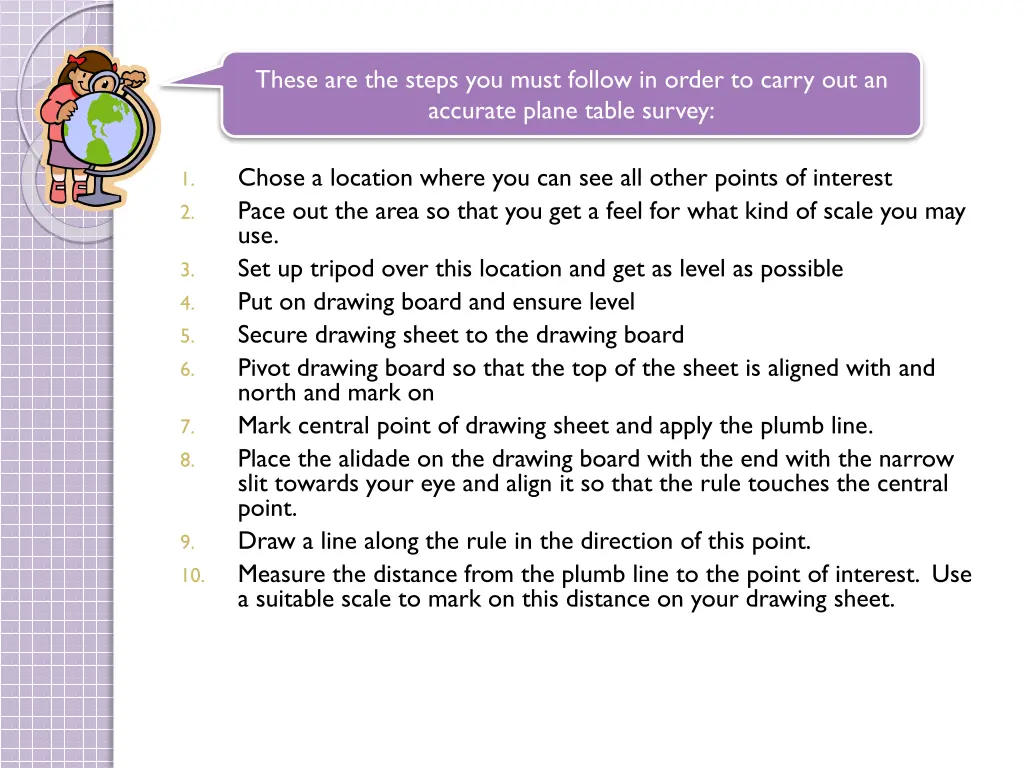
These are the steps you must follow in order to carry out an accurate plane table survey: Chose a location where you can see all other points of interest Pace out the area so that you get a feel for what kind of scale you may use. Set up tripod over this location and get as level as possible Put on drawing board and ensure level Secure drawing sheet to the drawing board Pivot drawing board so that the top of the sheet is aligned with and north and mark on Mark central point of drawing sheet and apply the plumb line. Place the alidade on the drawing board with the end with the narrow slit towards your eye and align it so that the rule touches the central point. Draw a line along the rule in the direction of this point. Measure the distance from the plumb line to the point of interest. Use a suitable scale to mark on this distance on your drawing sheet. 1. 2. 3. 4. 5. 6. 7. 8. 9. 10.
Methods of Plotting Radiation B C P Chose a point that you can see all required positions A
N Methods of Plotting Radiation 7cm B A A Measure with a tape C P 70m Chose a point that you can see all required positions A
N Methods of Plotting Radiation 7cm B A A Measure with a tape C 70m A
N 5cm Methods of Plotting B Radiation 7cm B A 50m A Measure with a tape C 70m A
N 5cm Methods of Plotting 4cm C B Radiation 7cm B A 50m A 40m Measure with a tape C 70m A
Methods of Plotting N B 5cm Radiation C P 4cm 7cm A 1:1000 A
Methods of Plotting N B Radiation P C A 1:1000 A
What could we use this map for? A farmer wants to know how big his field is so he knows how much seed to buy. 1 bag of seed will cover 0.5m2 How will he work out how many bags of seed he will need? You must find the area of the field from the scale drawing Convert it using the scale into the real life area Divide this area by the area 1 bag of seed will cover
What could we use this map for? The area of a square is hxb N The area of a triangle can be found by 0.5xhxb B Radiation P C 9x8 = 72 =36 cm2 2 2 A 1:1000 A
What could we use this map for? As the scale is 1:1000 36 cm2 on the map=36cm2 x 1000 in real life So in real life the area is 36000cm2 Or 3.6m2 N B Radiation So as 1 bag of seed will cover 0.5m2 P C We will need 3.6m2 = 7.2 bags of seed 0.5m2 A So the farmer will need to buy 8 bags of seed to cover his field. 1:1000