Cutting-Edge Satellite Technology for Improved Weather Forecasting
"Explore the innovative WIVERN satellite equipped with a 94 GHz cloud radar to enhance Numerical Weather Prediction models, providing global in-cloud winds and vital weather data. Discover the Doppler implementation concept, wind measurement techniques, and significant societal benefits from this advanced technology."

Download Presentation

Please find below an Image/Link to download the presentation.
The content on the website is provided AS IS for your information and personal use only. It may not be sold, licensed, or shared on other websites without obtaining consent from the author. If you encounter any issues during the download, it is possible that the publisher has removed the file from their server.
You are allowed to download the files provided on this website for personal or commercial use, subject to the condition that they are used lawfully. All files are the property of their respective owners.
The content on the website is provided AS IS for your information and personal use only. It may not be sold, licensed, or shared on other websites without obtaining consent from the author.
E N D
Presentation Transcript
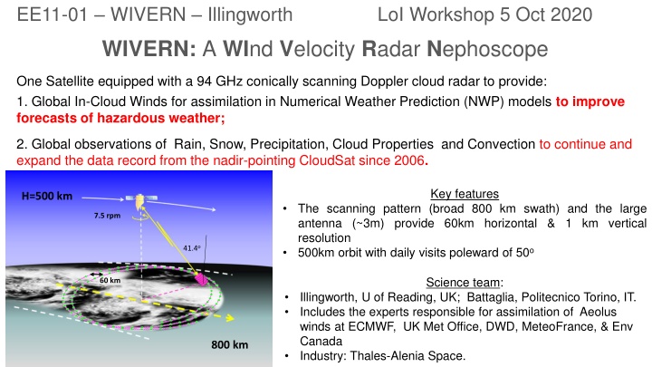
EE11-01 WIVERN Illingworth LoI Workshop 5 Oct 2020 WIVERN: A WInd Velocity Radar Nephoscope One Satellite equipped with a 94 GHz conically scanning Doppler cloud radar to provide: 1. Global In-Cloud Winds for assimilation in Numerical Weather Prediction (NWP) models to improve forecasts of hazardous weather; 2. Global observations of Rain, Snow, Precipitation, Cloud Properties and Convection to continue and expand the data record from the nadir-pointing CloudSat since 2006. Key features H=500 km The scanning pattern (broad 800 km swath) and the large antenna (~3m) provide 60km horizontal & 1 km vertical resolution 500km orbit with daily visits poleward of 50o 7.5 rpm 41.4o Science team: 60 km Illingworth, U of Reading, UK; Battaglia, Politecnico Torino, IT. Includes the experts responsible for assimilation of Aeolus winds at ECMWF, UK Met Office, DWD, MeteoFrance, & Env Canada Industry: Thales-Alenia Space. 800 km
Why winds? After temperature and humidity profiles wind profiles are extremely useful in data assimilation into NWP models. Wind data from the Aeolus wind lidar, launched in August 2018, with a fixed laser beam pointing 35deg off nadir, have been shown to have a significant impact in reducing NWP forecast errors. Aelous only measures winds in clear-sky regions and in tenuous ice clouds or the tops of water clouds before the lidar is extinguished. Wivern will provide complementary in-cloud-winds using cloud particles as tracers sampled over a wide (800km) swath, e.g. it will measure winds inside tropical cyclones and damaging Atlantic and Mediterranean storms where none are currently available. Societal benefit: significant improvement of extreme weather events (e.g. the European winter storm Lothar, 14.5B damage in Dec 1999).
DOPPLER IMPLEMENTATION CONCEPT: DOPPLER WINDS FROM SPACE at 94GHz. 1. Pulse pair approach: Measure the phase change from two successive transmitted pulses. +/- 180 if the targets have moved a quarter of a wavelength. (just 800 m at 94GHz) 2. 3. To measure high winds of 40m s-1, need separation of 20 secs (that is 3km in range). 4. To distinguish between the two pulses, one is horizontally (H) polarised, the other vertical (V). Technique validated by recent ESA funded dedicated ground-based and airborne observations. 3
SRL assessment SRL 5: End to end Performance Simulations A software package has been developed using observations and/or NWP as input, it generates I,Q returns at each radar gate for each pulse and feeds them into the algorithms leading to Doppler velocities and estimates of errors. SRL 6: Consolidated Science and Products. Polarization diversity technique validated by ESA-funded dedicated ground-based and airborne observations (same wind retrieval algorithm from space as from aircraft and at the ground). From the 14 year CloudSat global climatology of the 94 GHz cloud reflectivity we estimate that WIVERN should provide about one million winds per day with a precision of 1-2 m s-1. SRL 7: Demonstrated Science From ECMWF assimilation studies of Aeolus winds, the precision of the clear air winds is ~ 4 - 5 m s-1 and for cloud/aerosol winds 2 - 3 m s-1. The operational impact of the 200,000 Aeolus winds per day is found to be significant. This is extremely encouraging for a brand-new observation type. 4
TRL ASSESSMENT OF THE WIVERN RADAR Units Function Legacy / Commonality TRL AIDA Altimeter Integrated Digital Electronics Radar Central Electronics S3-NG (Nadir, Swath altimetry) OBP SKaR 3 Up/Down Converters Up and Down conversion W band Earth Care 7 HPA: 94 GHz EIK RF Power (2000 W peak) Earth Care radar (evolution of Cloudsat) 7-9 HPA: EPC Pulsed Power Supply SKIM, SCA/METOP-SG Earth Care 5 7 Dual Pol. Switching (1) Option two HPA (2) Option with single HPA TBD TBD (1) Low Power 94 GHz Switching (2) High Power 94 GHz Switching (1) 94 GHz HP Mechanical Switch (2) 94 GHz HP Quasi-Optical coupling HPA Redundancy (1) TBD (2) Earth Care TBD 7 94 GHz Antenna Conical Scann Antenna (40 deg) SKIM/SkaR, DORA 3 5
PROGRAMMATIC ELEMENTS 1. To our knowledge no similar mission is being proposed elsewhere. The ACCP (Aerosol, Clouds, Convection and Precipitation) concept being developed by NASA is complementary to WIVERN using 13/35/94GHz radars for process studies rather than for winds and data assimilation. 2. The assimilation infrastructure for the winds from Aeolus should be, with minor modifications, appropriate for WIVERN winds SCHEDULE AND COST ESTIMATE 1. No cost estimate given for LOI, just an indication based on EE10 which was well below 250 M . Costs will be given in full proposal. 2. Radar schedule is compatible with EE11 schedule. WIVERN RADAR SCHEDULE 2025 2021 2022 2023 2024 2026 2027 2028 2029 2030 Phase 0 Phase A Phase B1 Phase B2/CD 6