Elevation, Landforms, and Weathering: Assessing Geographical Features
This content presents assessments involving elevation maps, landform identification, elevation changes, and the effects of weathering and erosion on landscapes like mountains and granite formations. From analyzing maps to predicting geological changes over time, the content explores various aspects of geographical features and their evolution due to natural processes.

Download Presentation

Please find below an Image/Link to download the presentation.
The content on the website is provided AS IS for your information and personal use only. It may not be sold, licensed, or shared on other websites without obtaining consent from the author.If you encounter any issues during the download, it is possible that the publisher has removed the file from their server.
You are allowed to download the files provided on this website for personal or commercial use, subject to the condition that they are used lawfully. All files are the property of their respective owners.
The content on the website is provided AS IS for your information and personal use only. It may not be sold, licensed, or shared on other websites without obtaining consent from the author.
E N D
Presentation Transcript
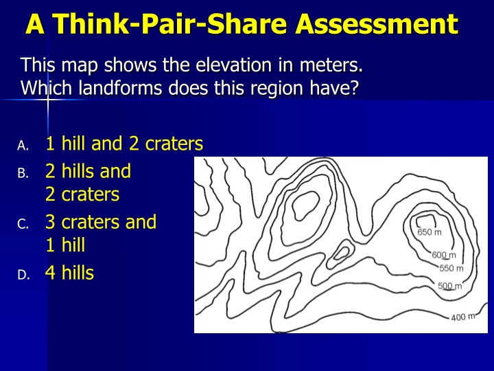
A Think-Pair-Share Assessment This map shows the elevation in meters. Which landforms does this region have? A. 1 hill and 2 craters B. 2 hills and 2 craters C. 3 craters and 1 hill D. 4 hills
This map shows the elevation in feet. What is the approximate change in elevation for the steepest path? A. 200 ft B. 300 ft C. 1740 ft D. 1800 ft 3 2 1
Predict how weathering and erosion may affect this mountain over time. A. The mountain may grow taller and rounder B. A river valley may form and empty the lake C. The bottom of the lake may deepen D. Any may be true
Below are satellite and topographic images of Enchanted Rock in central Texas, made of hard granite. Which may be true? A. The hilltops may become rounder as they erode. B. The large valley to the southeast may fill with sediments. C. The hills may become steeper as the sides erode faster than the top. D. Any may be true.