Exploring Sea Level Dynamics in Polar Regions and Coastal Areas
This investigation delves into understanding sea level variations in the New York Bight, Hudson Canyon, ocean temperature influence on sea level rise, polar regions around Greenland and West Antarctica, atmospheric temperature changes, and tide station observations. It explores the depths, temperature variations, and potential impacts on sea levels in these key areas, shedding light on the complex interactions between oceanic and atmospheric factors.

Download Presentation

Please find below an Image/Link to download the presentation.
The content on the website is provided AS IS for your information and personal use only. It may not be sold, licensed, or shared on other websites without obtaining consent from the author. If you encounter any issues during the download, it is possible that the publisher has removed the file from their server.
You are allowed to download the files provided on this website for personal or commercial use, subject to the condition that they are used lawfully. All files are the property of their respective owners.
The content on the website is provided AS IS for your information and personal use only. It may not be sold, licensed, or shared on other websites without obtaining consent from the author.
E N D
Presentation Transcript
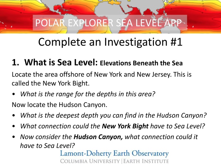
POLAR EXPLORER SEA LEVEL APP Complete an Investigation #1 1. What is Sea Level: Elevations Beneath the Sea Locate the area offshore of New York and New Jersey. This is called the New York Bight. What is the range for the depths in this area? Now locate the Hudson Canyon. What is the deepest depth you can find in the Hudson Canyon? What connection could the New York Bight have to Sea Level? Now consider the Hudson Canyon, what connection could it have to Sea Level?
POLAR EXPLORER SEA LEVEL APP Complete an Investigation #2 1. Why Does Sea Level Change: What is the role of the ocean:Internal Ocean Temperature (Present) Zoom down into the ocean. At what depth do the last two visible areas of warmer ocean water disappear? Can you identify those ocean features? How does ocean temperature relate to sea level rise? Explore the ocean temperatures at different depths. As you dive down in the layers of ocean water, at what depth does the majority of warm water appear to stop? How could this be significant in thinking about future sea level rise?
POLAR EXPLORER SEA LEVEL APP Complete an Investigation #2.5 1. Why Does Sea Level Change: What is the role of the ocean:Internal Ocean Temperature (Present) Now, focus on the polar regions Zoom down in the ocean around Greenland & West Antarctica What happens to the ocean temperature as you increase in depth? At what depth is the water around Greenland the coldest? And the warmest? What about Antarctica? How does it differ from the Atlantic and Pacific Oceans? Brainstorm ideas on what might be happening.
POLAR EXPLORER SEA LEVEL APP Complete an Investigation #3 1. Why Does Sea Level Change: What is the role of the atmosphere:Temperature change over last 5 years Click through different areas of the map. Where is the warming occurring at the greatest rate? How might this affect sea levels?
POLAR EXPLORER SEA LEVEL APP Complete an Investigation #5 1. Where is sea level changing now: Tide stations recording rising or falling Review the tide gauges and click around to see what some of the values are. See if you can locate where sea level rising the most? Consider different Earth processes.Can you create a hypothesis to explain this? Where do you find sea level is falling? Consider different Earth processes. Can you create a hypothesis to explain this?
POLAR EXPLORER SEA LEVEL APP Complete an Investigation #6 1. Where is sea level changing now: Regions vulnerable to future coastal flooding Zoom into the east coast of the U.S. and the Gulf of Mexico. What are the areas that are most severely impacted by flooding? How might this impact the residents in these areas? Name at least 3. What do you see that surprises you?
POLAR EXPLORER SEA LEVEL APP Complete an Investigation #7 1. Who is vulnerable: Population density Compare the population density" map to the tide stations recording rising and falling map. How does this map relate to sea level rise? Hypothesize area of highest vulnerability (i.e. which areas have high-density population and are vulnerable to sea level rise)? Are there possible mitigation strategies that you can think of for the high density and vulnerable populations?
POLAR EXPLORER SEA LEVEL APP Complete an Investigation #8 1. Who is vulnerable: Human impact on Earth Compare the Human Impact on Earth map to the Population Density" map. What do you think about this map, does anything about this map surprise you? Does this map generate any questions? How does it relate to the population density map? How might it relate to sea level rise?