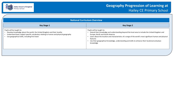
Geography Progression of Learning at Hailey CE Primary School
"Explore the geography curriculum at Hailey CE Primary School, covering knowledge about the world, the UK, and beyond, enhancing locational and place knowledge through various activities and skills."

Download Presentation

Please find below an Image/Link to download the presentation.
The content on the website is provided AS IS for your information and personal use only. It may not be sold, licensed, or shared on other websites without obtaining consent from the author. If you encounter any issues during the download, it is possible that the publisher has removed the file from their server.
You are allowed to download the files provided on this website for personal or commercial use, subject to the condition that they are used lawfully. All files are the property of their respective owners.
The content on the website is provided AS IS for your information and personal use only. It may not be sold, licensed, or shared on other websites without obtaining consent from the author.
E N D
Presentation Transcript
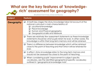
Geography Progression of Learning at Hailey CE Primary School National Curriculum Overview Key Stage 1 Key Stage 2 Pupils will be taught to: Develop knowledge about the world, the United Kingdom and their locality Understand basic subject-specific vocabulary relating to human and physical geography Use geographical skills, including first-hand Pupils will be taught to: Extend their knowledge and understanding beyond the local area to include the United Kingdom and Europe, North and South America Learn about the location and characteristics of a range of the world s most significant human and physical features Use their geographical knowledge, understanding and skills to enhance their locational and place knowledge
Locational & Place Knowledge Pegasus Unicorn Phoenix Griffin We will: 3 and 4 years Know that there are different countries in the world and talk about the differences that they have experienced or seen in photos We will: Name and locate the four countries and capital cities of the UK; England, Ireland, Scotland, Wales Name and locate the seas surrounding the UK. Talk about physical and human geographical similarities and differences between a small area of the UK, including seas, mountains, rivers and other key features Navigate our way around the classroom and school grounds Name and locate the world s seven continents. Name and locate the world s five oceans Talk about physical and human geographical similarities and differences between a small area of a non-European country Ask geographical questions e.g. -- What is it like to live in this place? How is this place different to where I live? Hailey/Witney We will: Name and locate places and countries we are studying Name and locate major cities in the countries we are studying Locate human and physical characteristics in the countries we are studying; including land-use patterns Talk about physical and human similarities and differences between different parts of the United Kingdom Learn how life has changed in / Rome (Ancient to modern day) Use maps, atlases, globes and digital/computer mapping (Google Earth) to locate the countries of Europe, including Russia Study the environmental regions of Europe (different areas defined by their environmental conditions, such as climate, landforms etc) Know and locate the world s seas and oceans. Name and locate the major cities of Europe on a map We will: Understand geographical similarities and differences through a study of human and physical geography of: - Region within N/S America (Brazil and the Amazon) compare to key aspects of the UK - Region in a European country (Greece) Name and locate countries and capital cities of the world and explain where they are in relation to one another Locate human and physical characteristics of the world drawing on previous learning Locate and study the major countries involved in WW2 (UK, Germany, Poland, Italy, Japan, USA etc) Name and locate counties and cities of the United Kingdom, geographical regions and identify physical and human features; comparing them to our own locality/county Use the terms latitude, longitude, Equator, North and South Hemisphere, Tropics of Cancer/Capricorn, Artic/Antarctic Circle and time zones Reception Draw information from a simple map Compare the similarities and differences between life in this country and life in other countries Recognise some environments that are different to the ones in which we live ELG Describe our immediate environment using knowledge from observation, discussion, stories, non-fiction texts and maps
Human & Physical Geography Pegasus Unicorn Phoenix Griffin We will: ELG Explain some similarities and differences between life in this country and life in other countries, drawing on knowledge from stories, non-fiction texts and (when appropriate) maps We will: Use basic geographical vocabulary to refer to key physical features: including beach, cliff, coast, forest, hill, mountain, sea, ocean, river, ford, stream, copse, housing estate Use basic geographical vocabulary to refer to key human features: including, city, town, village, factory, farm, house, office, shop Locate hot and cold areas of the world in relation to the Equator and the North and South Poles Identify seasonal and daily weather patterns in the UK We will: Describe and understand key aspects of physical geography: rivers and the water cycle Describe and understand key aspects of human geography: types of settlement and land-use Understand geographical similarities and differences through the study of human and physical geography of regions and cities in Europe Describe and understand key aspects of physical geography: including climate zones, rivers, mountains, volcanoes and earthquakes (natural disasters) Describe and understand key aspects of human geography: the impact of our extreme earth on our lives through the study of photographs, population numbers and other primary sources Draw conclusions; include diagrams and key geographical vocab We will: Describe and understand key aspects of physical geography: including climate zones, biomes and vegetation belts Describe and understand key aspects of human geography: including land use, economic activity including trade links, and the distribution of natural resources including energy, food, minerals and water Locate the main countries in Europe and the Americas; and identify their main environmental regions, key physical and human characteristics, and major cities Study modern land and settlements pre and post war compared to modern day ELG Understand some important processes and changes in the natural world around them, including the seasons and changing states of matter
Geographical Skills & Fieldwork Pegasus Unicorn Phoenix Griffin We will: 3 and 4 years Begin to understand the need to respect and care for the natural environment and all living things We will: Use world maps, atlases and globes to identify the UK and its countries Use simple compass directions (North, South, East and West), locational and directional language to describe the location of features and routes on a map Use simple fieldwork and observational skills to study the geography of the school grounds and the key human and physical features of its surrounding environment Use world maps, atlases and globes to identify the continents and oceans studied Use compass directions (North, South, East and West) to describe the location of features and routes on a map Devise simple maps and construct basic symbols in a key Use aerial photographs and plan perspectives We will: Use maps, atlases and globes to locate countries and describe features studied Use the eight-point compass, four-figure grid references, symbols and keys to build their knowledge of the United Kingdom Read four-figure grid references, symbols and keys Use maps, atlases and globes and digital/computer mapping to locate countries and describe features studied Use four-figure grid references, symbols and keys (including the use of Ordnance Survey maps) to build knowledge of the wider world Sketch maps of human and physical features Use and apply a range of mapping skills to different topics studied Devise and carry out surveys of the public to inform geographical research We will: Use maps, atlases, globes and digital mapping to locate countries and describe features studied Use the eight points of the compass, six-figure grid references, symbols and keys Choose effective recording and presentation methods e.g. tables to collect data Use maps, atlases, globes and digital/computer mapping to locate countries and describe features studied Use the eight points of a compass, four and six-figure grid references, symbols and key (including the use of Ordnance Survey maps) to further build knowledge of the United Kingdom and the wider world Collate and present data collected and record it using data handling software to produce graphs and charts of the results Ask Geographical questions e.g. How is traffic controlled? What are the main problems? Analyse evidence and draw conclusions Be aware of own responsibility in the world Make plans of the local area showing human and physical features Locate countries, continents and oceans using atlases, maps and digital maps, describing their features Reception Explore the natural world around us ELG Make observations and explain why some things occur; talk about changes