Geologic Interpretation of Panamint and Saline Valleys
Explore the geological history of Panamint and Saline Valleys through a detailed analysis of younger basalts and fault zones. Authors contend the contemporaneous formation of the valleys, supported by evidence of movement on the fault zone and basin histories. Palinspastic reconstruction and low-angle faulting reveal insights into the valley extensions and slip rates. Geophysics data and drill hole findings further support the interpretation, providing a comprehensive view of the region's geology.

Download Presentation

Please find below an Image/Link to download the presentation.
The content on the website is provided AS IS for your information and personal use only. It may not be sold, licensed, or shared on other websites without obtaining consent from the author. If you encounter any issues during the download, it is possible that the publisher has removed the file from their server.
You are allowed to download the files provided on this website for personal or commercial use, subject to the condition that they are used lawfully. All files are the property of their respective owners.
The content on the website is provided AS IS for your information and personal use only. It may not be sold, licensed, or shared on other websites without obtaining consent from the author.
E N D
Presentation Transcript
Younger Basalts Pre extension Basalts, 3.8-2.8 Ma Jurassic Hunter Mountain Batholith Hunter Mountain Fault Zone Panamint Butte Nova Fm basalts Darwin Plateau Mio-, Plio sed rx Pre-Cenozoic rx Nova Fm basalts Pre-Cenozoic rocks Nova Basin, relict older basin, presently stranded in the Panamint Range
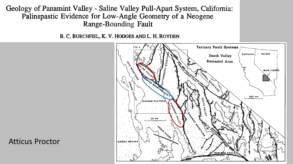
Authors contend the Panamint Valley and Saline Valley formed contemporaneously, supported by: HMFZ does not extend eastward beyond eastern boundary of Panamint valley, nor extend westward beyond western margin of Saline Valley No evidence for pre-late Cenozoic movement on the fault zone Jurassic Hunter Mountain Batholith Hunter Mountain Fault Zone Panamint Butte Nova Basin, relict older basin, presently stranded in the Panamint Range Darwin Plateau
Younger Basalts Pre extension Basalts, 3.8-2.8 Ma max age of valley ~3.0 Ma Displacement on the central part of the HMFZ is equal to the amount of extension in the northern Panamint Valley and Saline Valley. Nova Fm basalts Mio-, Plio sed rx Pre-Cenozoic rx Nova Fm basalts Pre-Cenozoic rocks
Palinspastic reconstruction of northern Panamint Valley 8-10km of right lateral net slip and 0-2km of down-to-the-south normal slip If Saline Valley and northern Panamint Valley extended contemporaneously, and the maximum age of the Saline Valley is 3.0 Ma, the slip rate on the fault is 2-3.2 mm/yr Restoring the low-angle normal detachment fault puts similarly aged basalts, that are across the valley in present day, back together Low angle detachment argument is reinforced by geophysics data and drill hole data that intercepted bedrock at 370ft in northern Panamint Valley
Interpretation No alternative reconstruction involving large-scale rotation of an initially high-angle structure produces and acceptable initial orientation of the volcanic units Northern Panamint Valley shows immense evidence for: Lots of extension can be accommodated by low angle faulting in the Great Basin Not all recent Basin and Range faulting is high-angle normal faulting Saline Valley shows a different style of extension than the northern Panamint Valley, thus low angle faulting is only one means of Basin and Range extension. Saline Valley geology actually precludes the detachment model there and favors closely spaced rotated faults Figure 4b, from Seedorff et al., 2015
Works Cited Burchfiel, B.C., Hodges, K.V. and Royden, L.H., 1987. Geology of the Panamint Valley - Saline Valley pull-apart system, California: Palinspastic evidence for low-angle geometry of a Neogene range-bounding fault. Journal of Geophysical Research, 92: 10422-10426. Seedorff, E., Richardson, C. A., Maher, D. J., Pennell, W. M., & Garside, L. J. (2015, May). Fault surface maps: Three-dimensional structural reconstructions and their utility in exploration and mining. In New concepts and discoveries: Proceedings, Geological Society of Nevada Symposium (Vol. 2, pp. 1179-1206).


