Geostatistical Distances Analysis in Spatial Studies
Geostatistics, a branch of statistics focusing on spatial datasets, plays a crucial role in various disciplines like geology, hydrology, and agriculture. Tobler's First Law of Geography forms the foundation of spatial analysis, emphasizing the relationship between proximity and interaction in spatial data analysis. Euclidean distance is a key metric used in spatial analysis to measure proximity between locations. By understanding geographic space and utilizing spatial analysis techniques, researchers can effectively evaluate spatial relationships in diverse domains.

Download Presentation

Please find below an Image/Link to download the presentation.
The content on the website is provided AS IS for your information and personal use only. It may not be sold, licensed, or shared on other websites without obtaining consent from the author. If you encounter any issues during the download, it is possible that the publisher has removed the file from their server.
You are allowed to download the files provided on this website for personal or commercial use, subject to the condition that they are used lawfully. All files are the property of their respective owners.
The content on the website is provided AS IS for your information and personal use only. It may not be sold, licensed, or shared on other websites without obtaining consent from the author.
E N D
Presentation Transcript
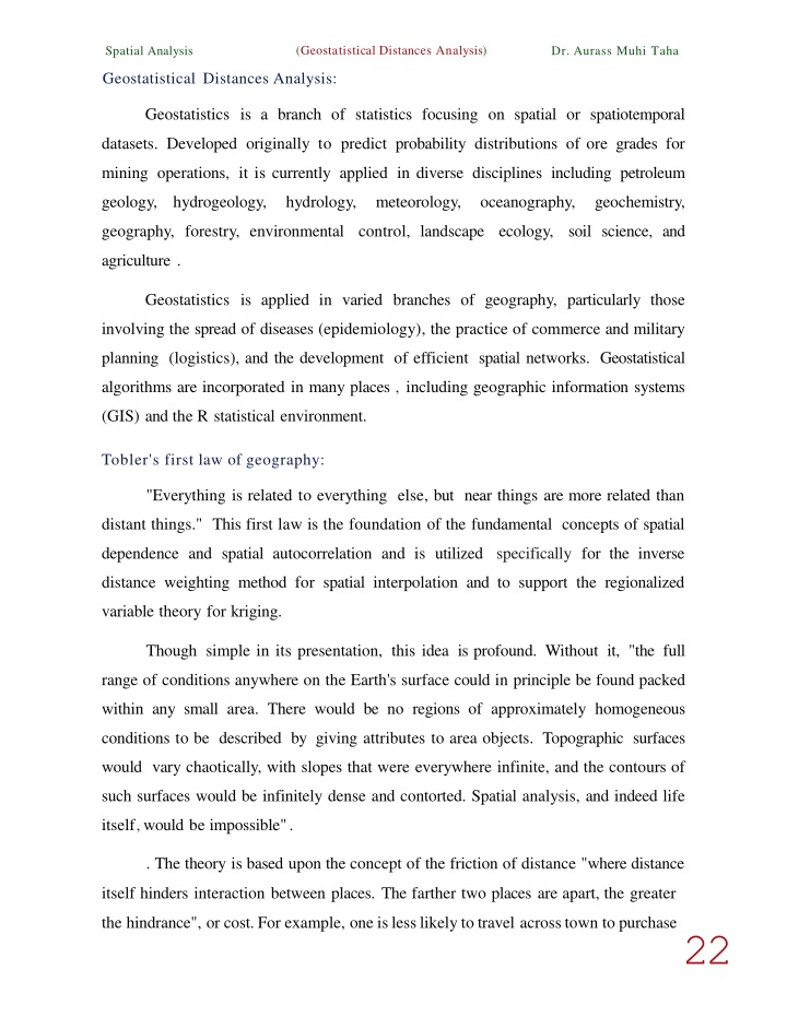
(Geostatistical Distances Analysis) Spatial Analysis Dr. Aurass Muhi Taha Geostatistical Distances Analysis: Geostatistics is a branch of statistics focusing on spatial or spatiotemporal datasets. Developed originally to predict probability distributions of ore grades for mining operations, it is currently applied in diverse disciplines including petroleum geology, hydrogeology, hydrology, meteorology, oceanography, geochemistry, geography, forestry, environmental control, landscape ecology, soil science, and agriculture . Geostatistics is applied in varied branches of geography, particularly those involving the spread of diseases (epidemiology), the practice of commerce and military planning (logistics), and the development of efficient spatial networks. Geostatistical algorithms are incorporated in many places , including geographic information systems (GIS) and the R statistical environment. Tobler's first law of geography: "Everything is related to everything else, but near things are more related than distant things." This first law is the foundation of the fundamental concepts of spatial dependence and spatial autocorrelation and is utilized specifically for the inverse distance weighting method for spatial interpolation and to support the regionalized variable theory for kriging. Though simple in its presentation, this idea is profound. Without it, "the full range of conditions anywhere on the Earth's surface could in principle be found packed within any small area. There would be no regions of approximately homogeneous conditions to be described by giving attributes to area objects. Topographic surfaces would vary chaotically, with slopes that were everywhere infinite, and the contours of such surfaces would be infinitely dense and contorted. Spatial analysis, and indeed life itself,would be impossible". . The theory is based upon the concept of the friction of distance "where distance itself hinders interaction between places. The farther two places are apart, the greater the hindrance", or cost. For example, one islesslikely to travel acrosstown to purchase22
Spatial Analysis Taha a sandwich than walk to the corner store for the same sandwich. In this example (Geostatistical Distances Analysis) Dr. Aurass Muhi hindrance, or cost, can readily be counted in time and transportation costs which are added to the price ofthe purchase and thus result in high levels of friction. The friction of distance and the increase in cost combine causing the distance decay effect. Geographic space: A mathematical space exists whenever we have a set of observations and quantitative measures of their attributes. For example, we can represent individuals' incomes or years of education within a coordinate system where the location of each individual can be specified with respect to both dimensions. The distance between individuals within this space is a quantitative measure oftheir differences with respect to income and education. However, in spatial analysis, we are concerned with specific types of mathematical spaces, namely, geographic space. In geographic space, the observations correspond to locations in a spatial measurement framework that capture their proximity in the real world. The locations in a spatial measurement framework often represent locations on the surface of the Earth, but this is not strictly necessary. A spatial measurement framework can also capture proximity with respect to, say, and interstellar space or within a biological entity such as a liver. The fundamental tenet is Tobler's First Law of Geography: if the interrelation between entities increases with proximity in the real world, then representation in geographic space and assessment using spatial analysis techniques are appropriate. The Euclidean distance between locations often represents their proximity, although this is only one possibility. There are an infinite number of distances in addition to Euclidean that can support quantitative analysis. The Euclidean distance: In mathematics, the Euclidean distance or Euclidean metric is the "ordinary" straight-line distance between two points in Euclidean space. With this distance, Euclidean space becomes a metric space. The associated norm is called 23
(Geostatistica l Distances Analysis) Spatial Analysis Dr. Aurass Muhi Taha the Euclidean norm. Older literature refers to the metric as the Pythagorean metric. A generalized term for the Euclidean norm is the (L2norm) or L2distance. The Euclidean distance between points (p) and (q) is the length of the line segment connecting them(pq ). In Cartesian coordinates, if p = {p1,p2, ,Pn} and q = {q1, q2, ,qn} are two points in Euclidean(n- space), then the distance (d) from (p) to (q), or from (q) to (p) be given by the (Pythagorean formula): ( q l - P1)2+ (q2 - P2)2+ + (qn - Pn)2= L(qi - Pi)2 n d(p,q) = d(q,p) = i=l The position of a point in a Euclidean ( n - space) is a Euclidean vector. So, (p) and (q) may be represented as Euclidean vectors, starting from the origin of the space (initial point) with their tips (terminal points) ending at the two points. The Euclidean norm, or Euclidean length, or magnitude of a vector measures the length of the vector: IIPII = .jpf +Pi+ + P = p.q, Where the last expression involves the dot product. q 24
(Geostatistical Distances Analysis) Spatial Analysis Dr. Aurass Muhi Taha Describing a vector as a directed line segment from the origin of the Euclidean space (vector tail), to a point in that space (vector tip), its length is actually the distance from its tail to its tip. The Euclidean norm of a vector is seen to be just the Euclidean distance between its tail and its tip. The relationship between point's p and q may involve a direction (for example, from p to q), so when it does, this relationship can itself be represented by a vector, given by: In a two- or three-dimensional represented as an arrow from (p) to(q). In any space it can be regarded as the position of q relative top. It may also be called a displacement vector if(p) and (q) represent two positions of some moving point. space(n 2 , 3),this can be visually = The Euclidean distance between (p) and (q) is just the Euclidean length of this displacement vector: llq- Pll = J ( q - p), ( q - p) Which is equivalent to equation d(p,q) = d(q,p) = /'Lf=1(qi - Pi)2 , and also to: llq- pll = )llpll2 + llqll2 - 2p *q 1. One Dimension: In the context of Euclidean geometry , a metric is established in one dimension by fixing two points on a line, and choosing one to be the origin. The length of the line segment between these points defines the unit of distance and the direction from the origin to the second point is defined as the positive direction. This line segment may be translated along the line to build longer segments whose lengths correspond to multiples of the unit distance. In this manner real numbers can be associated to points on the line (as the distance from the origin to the point) and these are the Cartesian coordinates of the points on what may now be called the real line. As an alternate way to establish the metric, instead of choosing two points on the line, choose one point to be the origin, a unit of length and a direction along the line to call positive. The second point is then uniquely determined as the point on the line that is at a distance of one positive unit from the origin. 25
(Geostatistical Distances Analysis) SpatialAnalysis Dr. Aurass Muhi Taha The distance between any two points on the real line is the absolute value of the numerical difference of their coordinates. It is common to identify the name of a point with its Cartesian coordinate. Thus if (p) and (q) are two points on the real line, then the distance between them is given by: ,j(q - p)2 = lq- pi In one dimension, there is a single homogeneous, translation-invariant metric (in other words, a distance that is induced by a norm), up to a scale factor of length, which is the Euclidean distance. In higher dimensions there are other possible norms. 2. Two Dimensions: In the Euclidean plane, if p given by: This is equivalent to the Pythagorean Theorem. Alternatively, it follows from liPII = ,jpf +Pi + + p = ,jp. q, that if the polar coordinates of the point (p) are (r1, 81) and those of (q) are (r2, 82), then the distance between the points is: d(p. qf - (q, - J>e)1 t- (t/: t - pz)! I I:tr-- P'l .d p 91 - PI PI Eudidean distance in R2 3. Three Dimensions: In three-dimensional Euclidean space, the distance is: 26
(Geostatistical Distances Analysis) SpatialAnalysis Dr. Aurass Muhi Taha 4. n Dimensions: In general, for ann-dimensional space, the distance is: The Manhattan distance: Also known as rectilinear distance is a form of geometry in which the usual distance function or metric of Euclidean geometry is replaced by a new metric in which the distance between two points is the sum of the absolute differences of their Cartesian coordinates. The rectilinear distance is also known as taxicab geometry , L1 distance,L1 distance or IIf11 1,snake distance, city block distance, Manhattan distance or Manhattan length, with corresponding variations in the name of the geometry. The latter names allude to the grid layout of most streets on the island of Manhattan, which causes the shortest path a car could take between two intersections in the borough to have length equal to the intersections' distance in taxicab geometry. y y ./ Euclidean X Manhattan Taxicab geometry versus E u d i d e <istance: Intax eab geometry. the red. yellow. and blue paths all h.lve lhe same shortest path l ength of 12I n Euclidean geometry. !he n line has ength islhe &Xique shortest path. n d1(p,q) =lip- qll =,LIPi- qd i=1 . . 1M and 27
")

")
")
")
")