Google Maps: A Detailed Overview of the Web Mapping Service
Explore the history, features, and advantages of Google Maps, a web mapping service launched in 2005 by Google. Discover how to use Google Maps on Android devices to navigate, search for locations, and plan trips efficiently. Learn about the benefits of using Google Maps for accessing real-time traffic data, satellite images, and public transportation schedules. Share maps with others and enhance coordination for gatherings, trips, and more.

Download Presentation

Please find below an Image/Link to download the presentation.
The content on the website is provided AS IS for your information and personal use only. It may not be sold, licensed, or shared on other websites without obtaining consent from the author. If you encounter any issues during the download, it is possible that the publisher has removed the file from their server.
You are allowed to download the files provided on this website for personal or commercial use, subject to the condition that they are used lawfully. All files are the property of their respective owners.
The content on the website is provided AS IS for your information and personal use only. It may not be sold, licensed, or shared on other websites without obtaining consent from the author.
E N D
Presentation Transcript
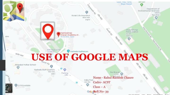
USE OF GOOGLE MAPS Name - Rahul Ramesh Chaure Cadre- ACST Class A Roll.No- 39
WHAT IS GOOGLE MAPS ? launched in 2005 web mapping service and technology supported by Google that can be used on desktop computers and smart phones provide various map information including satellite images, street view, weather, traffic, business locations and more Google Maps' satellite view is a "top-down" or "birds eye" view; most of the high- resolution imagery of cities is aerial photography
History Google Maps first started as a C++ program designed by two Danish brothers, Lars and Jens Eilstrup Rasmussen, at the Sydney-based company Where 2 Technologies It was first designed to be separately downloaded by users, but the company later pitched the idea for a purely Web-based product to Google management, changing the method of distribution.[ In October 2004, the company was acquired by Google Inc. where it transformed into the web application Google Maps n September 2004, Google acquired ZipDash, a company that provided realtime traffic analysis
How to use google maps On your Android phone or tablet, open the Google Maps app Search for a place or tap it on the map.In the bottom right, tap Directions. If you touch and hold the button instead, you ll start navigation and can skip steps 4-6 To add additional destinations, go to the top right and tap More. Add STOP You can add up to 9 stops. When you are finished, tap Done. Choose one of the following : Driving, Transit Walking , Rides, Cycling If other routes are available, they will be shown in gray on the map. To follow an alternate route, tap the gray line . To start navigation, tap Start . If you see Searching for GPS, your phone is trying to get a GPS signal. For example, you might be in or near a tunnel, parking garage, or other location where there s no GPS signal. To stop or cancel navigation, go to the bottom left and tap Close
USE IN A MOBILE STEP 2 select destination and search STEP 1- Select google map
Advantages of Using the Google Maps Google Maps provides the layout of roads, the locations of cities and towns, state boundaries, geographical features, restaurant reviews and satellite images You can share Maps with family, friends and colleagues, which makes gatherings easier to plan and coordinate. The Google Maps website gives you directions for trips by car, bike, foot or public transportation. The service has local bus and train schedules for many cities including bus and stop numbers and transfer points. For longer trips, Google provides airline information including ticket price and carriers that serve your destination Google began offering traffic data as a colored overlay on top of roads and motorways to represent the speed of traffic. Crowdsourcing is used to obtain the GPS-determined locations of a large number of cellphone users, from which live traffic maps are produced
Disadvantages of Using the Google Maps Limited Accuracy : Information in Google Maps may have errors. Occasionally, ambiguities and flaws in location data may produce a route that doesn't take you to the destination you expect. Google Maps does not have up-to-the-minute information on unusual conditions, such as roads damaged by weather, blocked by street fairs or altered by recent construction work. Use by Criminals :The convenience afforded by Google Maps is not lost on thieves. Street View images can spot belongings momentarily exposed through windows or open doors. Offensive and Shocking Material :The extra information that Google Maps provides, including Street View images and material from the public, sometimes has content Google has to remove. The Street View camera, for example, occasionally captures images of criminal behavior as it passes along country roads and through neighborhoods. Disturbing images and off-color and even racist public comments and references have appeared on the maps themselves.
CONCLUSION People nowadays are familiar with technology. With the development of smart phones, Google Maps, which is an essential and portable tool on directing, is getting more important and commonly-used. It is also embedded in many websites and applications that people are able to use it for different purposes, e.g. finding restaurants nearby and making taxi calls. It is likely that Google Maps will have a larger coverage of users in the near future as mapping technology is getting accessible to everyone with the aid of Internet. Google Maps is one of the innovations in the decade that brings great improvements to our lives.