Explore the development of topographic asymmetry through dated cinder cones in the Western United States. Understand the concept of ecohydrogeomorphic feedback and the significance of cinder cones in geological studies in various volcanic fields like SFVF, SVF, MLVF, and NVF. Learn about the methods used in gathering data for this insightful study.
Please find below an Image/Link to download the presentation.
The content on the website is provided AS IS for your information and personal use only. It may not be sold, licensed, or shared on other websites without obtaining consent from the author. If you encounter any issues during the download, it is possible that the publisher has removed the file from their server.
You are allowed to download the files provided on this website for personal or commercial use, subject to the condition that they are used lawfully. All files are the property of their respective owners.
The content on the website is provided AS IS for your information and personal use only. It may not be sold, licensed, or shared on other websites without obtaining consent from the author.
E N D
Presentation Transcript
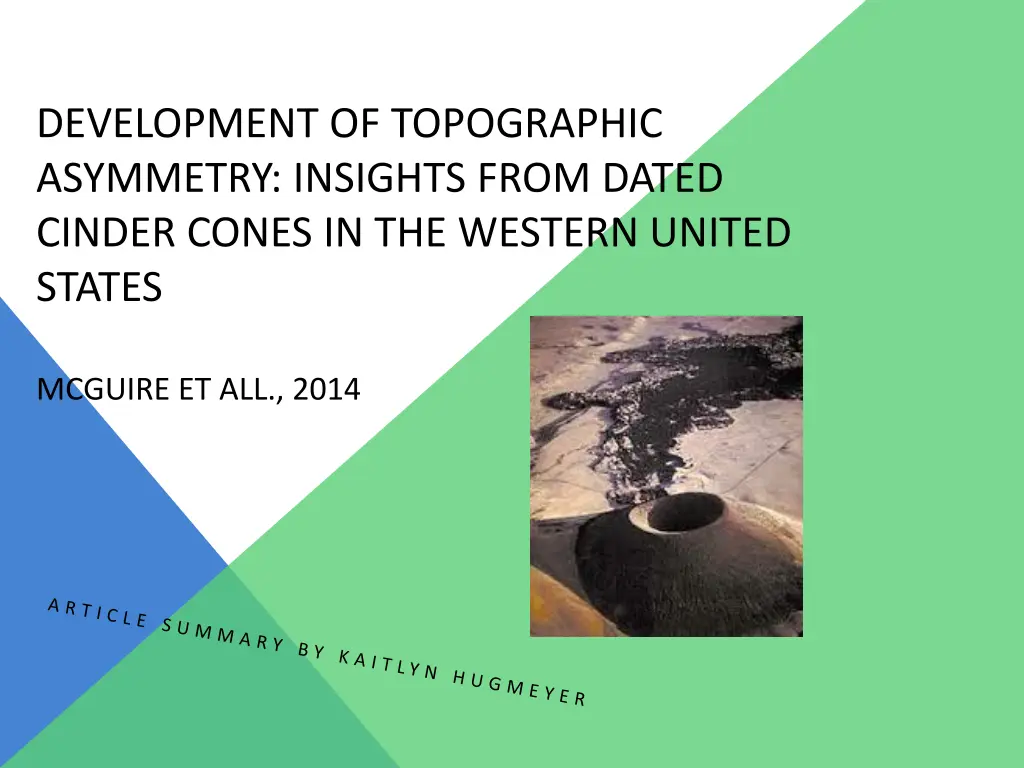
DEVELOPMENT OF TOPOGRAPHIC ASYMMETRY: INSIGHTS FROM DATED CINDER CONES IN THE WESTERN UNITED STATES MCGUIRE ET ALL., 2014
WHY CINDER CONES? Remember? Steep and conical Volcaniclastic debris They re datable Radiometric They re consistent Mineralogically homogenous Formation-days to years Highly permiable They re symmetrical (for the most part) Ideal young cinder cones are radially symmetric 26-36 degree hillslope angles Not all cinder cones chosen-asymmetries
THE STUDY The SFVF (San Francisco Volcanic Field) Northeastern Arizona 600 volcanic vents, several hundred basalt cinder cones Active for 6ma Semi arid (varies with elevation) 250-580mm annual precipitation 2000-2300m cinder cone elevation
THE STUDY The SVF (Springerville Volcanic field) East-central Arizona Covers 3000km^2 One large stratovolcano Pliocene-Pleistocene basaltic cinder cones 2.1-.3ma based on Ar/K dating 1900-3000m 250-750mm annual precipitation
THE STUDY The MLVF (the Medicine Lake Volcanic Field) Northeast California Large shield volcano and central caldera Basalt and basaltic andesite Southern part of Cascade Volcanic Arc 1500-2000m Average 750mm annual precipitation
THE STUDY The NVF (The Newberry Volcanic Field) Central Oregon Eastern side of cascade range Over 400 Halocene-late Pleistocene cinder cones Most cinder cones 1500-1800m 400-800mm annual precipitation (elevation dependent) *** some Devils Garden Volcanic Field basaltic cinder cones included in the study (30km SE of Newberry)
METHODS Gathering Data Hillslope angles Drainage density Area of all the streams and rivers divided by area of basin Lidar-derived DEMs- digital elevation models Previous geologic data (cinder cones) NDVI- normalized difference vegetation index (quantify for a controlled study) North-facing Solar radiation Albedo characteristics Pollen and sediment data for ancient vegetation data Deuterium concentrations in atmosphere for ancient climate-Vostok, Antarctica
CRAZY MATH NDVI=NIR-VIS/NIR+VIS (spectral reflectance in the near-infrared and visible regions) (precipitation effectiveness) (along-channel bed slope) (flow routing method) (sediment flux) (colluvium coefficient)
-The slope of the cinder cone gets shallower with age. RESULTS -higher hillslope angles on north slopes. More erosion on south- facing slope. -average angles are approximately 20 degrees. (200- 330 ka for slopes to degrade to that angle. -mechanisms that drive asymmetry (freeze-thaw and bioturbation) require soil development capable of holding moisture and vegetation.
RESULTS -drainage density is low, but increases with age. Young cinder cones are extremely porous and permeable which makes it difficult to retain moisture and develop soil. When relief degrades, it decreases again. -less vegetation means more slope wash. -vegetation impacts slope stability. -climate and elevation effect sediment transport mechanisms, which effect hillslope gradients.