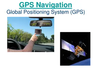
Insights into the Global Positioning System: Components and Segments
Explore the key components and segments of the Global Positioning System (GPS), including the Space Segment, Control Segment, and User Segment. Learn about the satellites, control stations, and wide range of applications of GPS technology in various devices and industries.

Download Presentation

Please find below an Image/Link to download the presentation.
The content on the website is provided AS IS for your information and personal use only. It may not be sold, licensed, or shared on other websites without obtaining consent from the author. If you encounter any issues during the download, it is possible that the publisher has removed the file from their server.
You are allowed to download the files provided on this website for personal or commercial use, subject to the condition that they are used lawfully. All files are the property of their respective owners.
The content on the website is provided AS IS for your information and personal use only. It may not be sold, licensed, or shared on other websites without obtaining consent from the author.
E N D
Presentation Transcript
Global Positioning System Alex Liang and Akhil Maddukuri
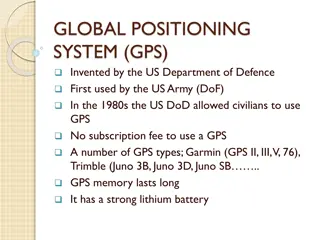
3 Components 1) The space segment - Actual GPS satellites 2) Control system - Operated by US DoD 3) User segment - Includes both military and civilian users and their GPS equipment
Space Segment The US commits to maintain at least 24 operational GPS satellites, 95% of the time Satellites in the GPS constellation are arranged into six equally-spaced orbital planes surrounding the Earth GPS satellites fly in medium Earth orbit at approximately 20, 200 km in altitude, with each satellite circling the Earth twice a day
Space Segment (Continued) Each satellite broadcasts navigation message based upon data uploaded from Control Segment and adds the message to a 1.023 MHz Pseudo Random Noise (PRN) code sequence Satellite converts the code sequence onto a 1575.42 MHz L-band carrier to create a spread spectrum ranging signal L-band is range of radio signals from 1 to 2 GHz L-band waves penetrate clouds, fog, rain, storms, and vegetation - accurate signal transmission Spread Spectrum modulation is a method in which a signal generated with one bandwidth is spread in the frequency domain to create a signal with wider bandwidth
Control Segment GPS Control Segment (CS) is comprised of four major components: Master Control Station (MCS) Backup Master Control Station (BMCS) Four ground antennas Six monitor stations MCS is based in Schriever Air Force Base, Colorado - operated 24/7 Roles: Navigation data upload operations, Detection and response for service failures, satellite maintenance CS's four ground antennas provide real-time Telemetry, Tracking, and Commanding (TT&C) interface between the GPS satellites and the MCS Six monitor stations provide real-time satellite ranging measurement data to MCS
User Segment Used in everything from cell phones and wristwatches to bulldozers, shipping containers, and ATM's Critical to U.S. national security - nearly all new military assets from vehicles to munitions are equipped with GPS
How Does GPS Work? Radio waves - - Travel at the speed of light Calculates receiver position by how long signals take to reach Velocity x time = distance - Satellites are constantly monitored and predictable
How Does GPS Work? Pseudo-random code as receivers - Digital Code - measures the timing delay from GPS to receiver Football field reference - Special atomic clocks - Oscillations of an atom as 24 metronome provide the most accurate time Receiver clocks aren t as accurate -
How Does GPS Work? Around 21 satellites in orbit - - Only need 3 to pinpoint location Having more is more accurate but receivers must be developed to have the channels Two channel compromise - - 1 performs time measurement calculations Other moves on to the next one right away
Challenges Ionosphere delays - Region of charged particles above earth Predict an everyday average or looking at relative speeds of two different signals - Atmospheric delays - Clouds, water vapor, etc can also affect speed of light
Challenges Satellite errors - - Atomic clock errors Constant monitoring by the DoD Receiver errors - - Electrical interference Rounding off mathematical calculations
Governmental Control of GPS GPS is a global navigation satellite system, or GNSS Few exist due to high cost and complex infrastructure of developing and maintaining a GNSS All are controlled by nation-states Only Russia s GLONASS offers the equivalent full global coverage and a complete satellite constellation EU s Galileo system began in 2011 and will require until 2025 for full operability China s Beidou system currently offers limited service and will mature around same time Other states want to establish political independence - problems of disunity?


")