It's All Connected: Identifying Mid Latitude Cyclones and Forecasting Fire Weather
This work funded by the National Science Foundation delves into the interconnected nature of identifying mid latitude cyclones and forecasting fire weather. Through exercises, examples, and jigsaw activities, students learn about air masses, fronts, wind patterns, and extreme fire weather risks. The content focuses on hands-on learning to analyze weather maps, make predictions, and collaborate in teams to outline areas of concern. It provides a comprehensive overview of meteorological concepts essential for understanding weather patterns at mid latitudes.

Download Presentation

Please find below an Image/Link to download the presentation.
The content on the website is provided AS IS for your information and personal use only. It may not be sold, licensed, or shared on other websites without obtaining consent from the author.If you encounter any issues during the download, it is possible that the publisher has removed the file from their server.
You are allowed to download the files provided on this website for personal or commercial use, subject to the condition that they are used lawfully. All files are the property of their respective owners.
The content on the website is provided AS IS for your information and personal use only. It may not be sold, licensed, or shared on other websites without obtaining consent from the author.
E N D
Presentation Transcript
Unit 4.5: It's All Connected, Right? This work was funded by the National Science Foundation through grant #2013338, Teaching with Investigation and Design in Science (TIDeS). The opinions, findings, conclusions, and recommendations expressed are those of the authors and do not necessarily reflect the views of the NSF.
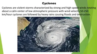
Identifying Mid Latitude Cyclones- Intro Before we can dive in and identify mid latitude cyclones, we need to first familiarize ourselves with conditions necessary for them to form. Complete the following worksheet in order: Exercise 1: Air Masses Around the US Exercise 2: All About the Fronts Exercise 3: Mid Latitude Cyclone or Hurricane? Each team will work together to: 1. Label and analyze a Daily Weather Map with the following: Fronts Wind Direction 2. Make predictions for where a mid latitude cyclone may form. State specific evidence to back your claims
Identifying Mid Latitude Cyclones Example
Identifying Mid Latitude Cyclones Answer https://www.wpc.ncep.noaa.gov/dailywxmap/pdf/DWM_20221222.pdf
Forecasting Fire Weather Jigsaw- Intro NM wildfire update and weather forecast Fire crews from the ground and air continue to fight the massive wildfires burning in the state.
Forecasting Fire Weather Jigsaw- Part 1 Students will split into teams of 4 and each person in the group will have a different map distributed to them. They will regroup based on the map they receive: Forecast minimum relative humidity (percent) Forecast maximum wind gust (kts) Forecast cloud cover, to be used as a proxy for temperature Estimated rainfall in the previous three days (inches)
Forecasting Fire Weather Jigsaw- Part 2 Go back to your original groups! Go around the table and have each member explain their map to the group On your new map (blank), outline the area of extreme fire weather risk inside a broader area of elevated fire risk Teams must submit their map and a short narrative (in bullet point format) outlining their decision and support it with evidence
Storm Prediction Center Day 1 Fire Weather Outlook