Explore the regional tilt patterns of late Cenozoic basin-range fault blocks in the western United States, including extension directions, bed tilting, and the relationship between tilting and extensional faulting. Discover the method of deriving extension from range tilts and the proposed initial rupture locations.
Please find below an Image/Link to download the presentation.
The content on the website is provided AS IS for your information and personal use only. It may not be sold, licensed, or shared on other websites without obtaining consent from the author. If you encounter any issues during the download, it is possible that the publisher has removed the file from their server.
You are allowed to download the files provided on this website for personal or commercial use, subject to the condition that they are used lawfully. All files are the property of their respective owners.
The content on the website is provided AS IS for your information and personal use only. It may not be sold, licensed, or shared on other websites without obtaining consent from the author.
E N D
Presentation Transcript
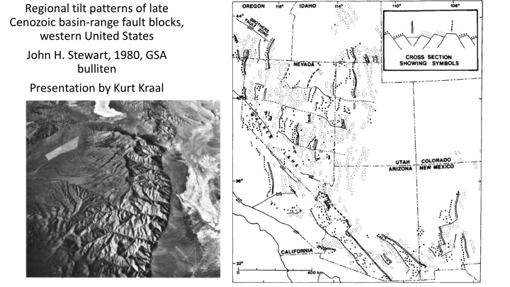
Regional tilt patterns of late Cenozoic basin-range fault blocks, western United States John H. Stewart, 1980, GSA bulliten Presentation by Kurt Kraal
Regional Tilt Patterns E or W tilt directions that can be broken up into various domains These zones are separated by west- northwest trending transverse zones or bounderies. these domains have an absence of major tilted blocks by changes in the density and pattern of young faults, and changes in topographic grain Often correspond to defined lineaments Extension Directions: In the GB, extension direction is perpendicular to basin bounding structures (and parallel with transverse structures) Different direction than Southern B&R (possibly due to different timing?)
Bed Tilting: Extension Based on tilted block model (although similar relationships of higher tilting = higher extension for the listric fault model would be expected) from Morton and Black 1975 Most measurements suggest 0-32 degrees of tilting, therefore 5-73% extension in most ranges
Deriving extension from range tilts - stretched width of the basin is the amount of extension = original width of the basin Rotating from fault dip 60o to 30o gives = 1.7 James Jackson - Trieste
amount of extension () is related to tilting but topography is related to block width James Jackson - Trieste
Initial rupture proposed to occur antiformal boundaries that propagate until hitting already ruptured and tilted blocks
Conclusions Tilting of 15 to 20 o observed regionally in the GB correlates with 20-30% extension over the entire great basin (using the model proposed by Morton and Black 1975) Block rotation or listric fault proposed as possible models


")