Locations of Ground Radars and Flight Modules for OLYMPEX Operation
This content provides details about the ground radars and flight modules used in the OLYMPEX operation. It includes information on radar locations, suggested flight modules, and roles of key personnel involved in the operation.

Download Presentation

Please find below an Image/Link to download the presentation.
The content on the website is provided AS IS for your information and personal use only. It may not be sold, licensed, or shared on other websites without obtaining consent from the author.If you encounter any issues during the download, it is possible that the publisher has removed the file from their server.
You are allowed to download the files provided on this website for personal or commercial use, subject to the condition that they are used lawfully. All files are the property of their respective owners.
The content on the website is provided AS IS for your information and personal use only. It may not be sold, licensed, or shared on other websites without obtaining consent from the author.
E N D
Presentation Transcript
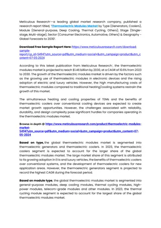
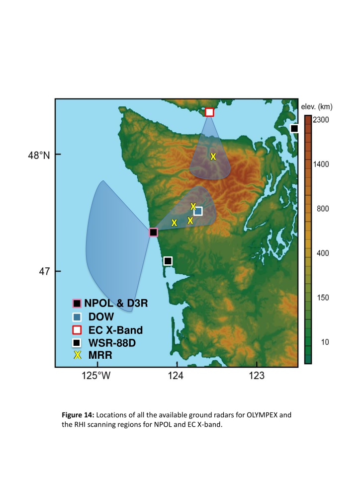
X X X X NPOL & D3R DOW EC X-Band WSR-88D MRR X Figure 14: Locations of all the available ground radars for OLYMPEX and the RHI scanning regions for NPOL and EC X-band.
Attributes of suggested modules Suitable for any of the 3 sectors o prefrontal o frontal o postfrontal , Are short enough that they can be repeated within a given aircraft deployment Can be executed singularly or in multi-aircraft mode Can cover the Quinault o Oceanic upstream of the Olympics o windward side over the Quinault y network o leeside Hurricane Ridge sector Can be shifted to the Chehalis for storms to the sout of the Olympic Range Can be interspersed with a module to underfly a satellite overpass
X-band ER-2 modified butterfly pattern NPOL ER-2 Figure 16: Generic flight module for the ER-2 aircraft
X-band Generic DC-8 pattern with dropsondes at white circles NPOL DC-8 Figure 17: Generic flight module for the DC-8 aircraft.
X-band Generic Citation pattern with spiral at circle NPOL Figure 18: Generic flight module for the Citation aircraft.
X-band All aircraft with stacked pattern over Quinault River ground instrumentation NPOL ER-2 DC-8 Figure 19: Generic coordinated aircraft flight modules.
Roles in Operation OLYMPEX Lead Scientist (OLS) Bob, Walt, Lynn, Steve, RADEX Lead Scientist (RLS) Jay, Roger, Aircraft Project Manager (each aircraft) (APM) Chris (DC-8), Mike (Citation), Fran (ER-2) Aircraft Mission Scientist (AMS) DC-8 and ER-2 Flight Coordination Director (FCD) Jan, backup Platform PIs
Operations Center Location for daily meetings and small conferencing: o 2 rooms, 6th floor, ATG Bldg. Location for communications (Jan) o Basement ATG Bldg.
Daily Meeting Weather briefing o Lynn s UW crew Project status review Status of all platforms and instruments Plans for the next 2 days surface observations o radars o soundings o aircraft
Enchanted Valley Tipping Bucket Network Bunch Field Graves Creek CRN Site DOW Amanda Park Wynoochee Trailer Norwood Neilton Pt Fish Hatchery NPOL Seed Orchard Wallace Cabin = Low Elev. With Power = Low Elev. No Power = High Elev. With Power = High Elev. No Power Figure 8: Locations of the surface network (triangles)and the NPOL and DOW radars (squares) deployed for OLYMPEX. See Table 1 for the instruments to be deployed at each station.