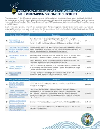
Michigan Statewide GIS Data Repository Requirements
Explore the mandatory fields and guidelines for loading GIS data into Michigan's Statewide 911 GIS Repository, ensuring compliance with NENA NG911 Data Schema. Key requirements include jurisdiction-specific data, unique IDs, and agency coordination for schema migration. Prepare your GIS data with essential points and centerlines conforming to specified fields to facilitate efficient data management.

Download Presentation

Please find below an Image/Link to download the presentation.
The content on the website is provided AS IS for your information and personal use only. It may not be sold, licensed, or shared on other websites without obtaining consent from the author. If you encounter any issues during the download, it is possible that the publisher has removed the file from their server.
You are allowed to download the files provided on this website for personal or commercial use, subject to the condition that they are used lawfully. All files are the property of their respective owners.
The content on the website is provided AS IS for your information and personal use only. It may not be sold, licensed, or shared on other websites without obtaining consent from the author.
E N D
Presentation Transcript
Michigan Statewide 911 GIS Repository Data Importer Onboarding Training Mark Holmes, GISP DTMB Center for Shared Solutions May 12, 2022
Statewide 911 GIS Repository Roles HELP. CONNECT. SOLVE.
NG911 GIS Data Readiness HELP. CONNECT. SOLVE.
Repository Data Requirements Repository follows current NENA NG911 Data Schema Recommendations for moving to new schema Highly recommended- adopt current NENA NG911 Data Schema for your GIS data Option 2 add key fields for NG911 GIS data readiness Limited Term Option have minimum required fields with plan to move towards new schema (this requires a lot of coordination with DTMB) Need to have mandatory fields completed in your source data HELP. CONNECT. SOLVE.
Repository Data Requirements Loading Features Only load features within your jurisdictional areas. If you have additional data outside of your area, you need to remove those features May need to coordinate with neighboring authoritative data maintainer on who is loading which features Download tools will be using County fields to extract data from repository so those are key mandatory fields along with Discrepancy Agency ID and Unique ID HELP. CONNECT. SOLVE.
Repository Data Requirements Structure Points Minimum (Mandatory) required fields Structure Points Unique ID Address Number Street Pre-Directional Street Name Street Type Street Post Directional Municipality (city, township) County, Country, State Date Updated Discrepancy Agency ID (domain of organization maintaining data e.g. co.name.mi.us) HELP. CONNECT. SOLVE.
Repository Data Requirements Road Centerlines Minimum (Mandatory) required fields Road Centerlines Unique ID Street Pre-Directional Street Name Street Type Street Post Directional Municipality (city, township) Left From and To Ranges Right From and To Ranges County, Country, State (Left and Right) Date Updated Discrepancy Agency ID (domain of organization maintaining data e.g. co.name.mi.us) HELP. CONNECT. SOLVE.
Road Centerline Attributes Road Names NG911 Fields (CLDXF Model) Legacy Fields St_PreMod St_PreDir North LSt_PreDir N ST_PReTyp St_PreSep ST_Name Main LSt_Name MAIN St_PostTyp Street LSt_Type ST ST_PostDIr LSt_PosDir St_PosMod HELP. CONNECT. SOLVE.
Required Fields Minimum required fields Unique ID Make sure it is static Recommendation is ID include discrepancy agency ID to separate from other numeric IDs from other contributors Example of NG911 Schema Unique IDs HELP. CONNECT. SOLVE.
Road Name Formats NENA NG911 Data Schema NG911 Street Name Fields and Legacy Fields NG911 Street Name Fields Use CLDXF Formats Street Name Pre Types and Street Name Post Types (nena.org) https://cdn.ymaws.com/www.nena.org/resource/resmgr/standards/nena-sta-006.1.1-2020_ng9-1-.pdf https://cdn.ymaws.com/www.nena.org/resource/resmgr/Standards/NENA-STA-004.1.1-2014_CLDXF.pdf Example of NG911 Schema Street Names HELP. CONNECT. SOLVE.
Road Centerline Attributes Road Names Recommendation NG911 Fields (CLDXF Model) Legacy Fields Recommendation- Migrate to new NG911 geodatabase schema and update road names into new CLDXF formats St_PreMod St_PreDir North LSt_PreDir N Option 2 Add street name NG911 Fields to your schema and update road names into new CLDXF formats ST_PReTyp St_PreSep ST_Name Main LSt_Name MAIN St_PostTyp Street LSt_Type ST ST_PostDIr LSt_PosDir St_PosMod HELP. CONNECT. SOLVE.
Road Centerline Attributes Road Names Short Term Option NG911 Fields (CLDXF Model) Legacy Fields St_PreMod St_PreDir N LSt_PreDir N Short Term Option - Add NG911 Fields to your schema and use your current road names in both with plan to format NG911 field values to CLDXF Model ST_PReTyp St_PreSep ST_Name MAIN LSt_Name MAIN St_PostTyp ST LSt_Type ST ST_PostDIr LSt_PosDir St_PosMod HELP. CONNECT. SOLVE.
Road Centerline Attributes Road Names Example NG911 Fields (CLDXF Model) Legacy Fields St_PreMod Old St_PreDir North LSt_PreDir ST_PReTyp St_PreSep ST_Name Church LSt_Name OLD NORTH CHURCH St_PostTyp Street LSt_Type ST ST_PostDIr LSt_PosDir St_PosMod HELP. CONNECT. SOLVE.
Road Centerline Attributes Road Names Example (2) NG911 Fields (CLDXF Model) Legacy Fields St_PreMod St_PreDir LSt_PreDir ST_PReTyp Avenue St_PreSep ST_Name A LSt_Name AVENUE A St_PostTyp Street LSt_Type ST ST_PostDIr LSt_PosDir St_PosMod HELP. CONNECT. SOLVE.
Road Centerline Attributes Road Names Example (3) NG911 Fields (CLDXF Model) Legacy Fields St_PreMod St_PreDir LSt_PreDir ST_PReTyp Boulevard St_PreSep of the ST_Name Allies LSt_Name BLVD OF THE ALLIES St_PostTyp LSt_Type ST_PostDIr LSt_PosDir St_PosMod HELP. CONNECT. SOLVE.
Road Centerline Attributes Road Names Example (4) NG911 Fields (CLDXF Model) Legacy Fields St_PreMod St_PreDir LSt_PreDir ST_PReTyp St_PreSep ST_Name Main LSt_Name MAIN STREET NORTH EXTENSION St_PostTyp Street LSt_Type ST_PostDIr North LSt_PosDir St_PosMod Extension HELP. CONNECT. SOLVE.
Road Centerline Attributes New NG911 Fields NG911 Fields Example Discrepancy Agency ID County.org or co.countyname.mi.us DateUpdated 8/3/2021 7:35:21 PM NENA Globally Unique ID RCL_111111@county.org Country US State MI County Any County Incorporated Community Any Township HELP. CONNECT. SOLVE.
Road Centerline Attributes New NG911 Fields (2) NG911 Fields Example Address Number Prefix or Suffix 1/2 in 321 Main Street Parity Left O=Odd, E=Even, B=Both, Z=Address Range 0-0 Parity Right O=Odd, E=Even, B=Both, Z=Address Range 0-0 Place Type Airport, Bank, Office, Hotel Building Building Name Unit Type Apt Unit 23 Floor Room HELP. CONNECT. SOLVE.
Response Boundaries Separate Out Fire, Law, EMS Loaded as separate boundaries If you have one layer for all emergency service zone, steps can be used to pull them out into separate layers Future training sessions will be held on these layers and validations Statewide layer will highlight areas where neighboring jurisdictions my need to perform edge-matching PSAP boundary review period during onboarding timeline More communication to PSAP Administrators and Data Importers HELP. CONNECT. SOLVE.
MiLogin Single Sign On Data Import Tools Via Michigan Geographic Framework Data Gateway HELP. CONNECT. SOLVE.
Contributor Guide to MILogin Setup for MGF Data Gateway Login set up for Michigan Geographic Framework Data Gateway Step 1: Go to https://milogintp.michigan.gov/ Step 2: Login if you have an account or sign up if you need to create an account HELP. CONNECT. SOLVE.
Contributor Guide to MILogin Setup for MGF Data Gateway (2) HELP. CONNECT. SOLVE.
Contributor Guide to MILogin Setup for MGF Data Gateway (3) HELP. CONNECT. SOLVE.
Contributor Guide to MILogin Setup for MGF Data Gateway (4) If you have account or once you have created a MiLogin account Step 3: Go to https://milogintp.michigan.gov/ and sign in Step 4: At the top of the page click Request Access HELP. CONNECT. SOLVE.
Contributor Guide to MILogin Setup for MGF Data Gateway (5) Step 5: In the Search Application field, enter Michigan Geographic Framework Data Gateway and select. HELP. CONNECT. SOLVE.
Contributor Guide to MILogin Setup for MGF Data Gateway (6) Step 6: Agree to the terms and conditions. HELP. CONNECT. SOLVE.
Contributor Guide to MILogin Setup for MGF Data Gateway (7) Step 7: DTMB will receive an email that you are seeking approval for access to Michigan Geographic Framework Data Gateway, once accepted you can continue onto the next step. Step 8: Once you have approval. Login to MiLogin. Go to Michigan Geographic Framework Data Gateway Step 9: Select Sign in with MILogin Third Party External User If you are having trouble with MILogin, DTMB will have a helpdesk support email that you can send questions to DTMB-NG911GIS@michigan.gov HELP. CONNECT. SOLVE.
Data Provisioning Info Required to Be Emailed Please email the following information to DTMB-NG911GIS@michigan.gov Discrepancy Agency ID (agency of GIS data maintainer e.g. co.name.mi.us) GIS Data Maintainer Contact Info First and Last Name Address Email Telephone MiLogin user name If Secondary GIS Data Maintainer, please email contact info for that person Geographic extent for area being uploaded Attach agency logo (optional) will be used for Data Gateway interface All of this information will be used to initialize data importing tools Importing tools will only be made available to those on permissions form submitted by PSAP Administrator HELP. CONNECT. SOLVE.
Repository Functionality Demos HELP. CONNECT. SOLVE.
Statewide 911 GIS Repository Import HELP. CONNECT. SOLVE.
Statewide 911 GIS Repository Import (2) HELP. CONNECT. SOLVE.
Statewide 911 GIS Repository Import Steps Available Essential Geometry Checks (pre-load check) Attribute Validations (pre-load check) Change Detection (upload to repository process) Fishbone Validation (periodic check) Cross Feature Validation (periodic check) Shapefiles or File Geodatabases are accepted Must be zipped up to drag and drop Must have a unique ID on all records HELP. CONNECT. SOLVE.
Statewide 911 GIS Repository Import (3) HELP. CONNECT. SOLVE.
Repository Functionality Essential Geometry Checks HELP. CONNECT. SOLVE.
Essential Geometry Checks This check can be used for all geometry types No specific tiles for each datasets Found in My Assignments on left side contents HELP. CONNECT. SOLVE.
Essential Geometry Checks (2) Drag and drop zip file Can be shapefile or file geodatabase HELP. CONNECT. SOLVE.
Essential Geometry Checks (3) Set Target Class to Feature HELP. CONNECT. SOLVE.
Essential Geometry Checks (4) Set Geometry field and set unique ID filed to UniqueID Then Click Continue HELP. CONNECT. SOLVE.
Essential Geometry Checks (5) HELP. CONNECT. SOLVE.
Essential Geometry Checks (6) HELP. CONNECT. SOLVE.
Essential Geometry Checks (7) HELP. CONNECT. SOLVE.
Essential Geometry Checks (8) HELP. CONNECT. SOLVE.
Essential Geometry Checks (9) HELP. CONNECT. SOLVE.
Essential Geometry Checks (10) HELP. CONNECT. SOLVE.
Essential Geometry Checks (11) HELP. CONNECT. SOLVE.
Essential Geometry Checks (12) HELP. CONNECT. SOLVE.
Essential Geometry Checks (13) HELP. CONNECT. SOLVE.
Essential Geometry Checks (14) HELP. CONNECT. SOLVE.
Essential Geometry Checks (15) Submissions not closed can be accessed in top right If submissions are left open after 24 hours will produce error message HELP. CONNECT. SOLVE.
Repository Functionality Attribute Validations HELP. CONNECT. SOLVE.


")
")
")

")


")
")
")
")
")
")


")

")


")
")
")
")
")
")
")
")
")
")
")
")
")
")