Oceanic Zonation and Sedimentary Basin Characteristics
Explore the vertical and horizontal zonation of ocean environments, including benthic and pelagic depth zones, along with the distribution of pelagic organisms. Learn about basin axes and controls on sediment accumulation influenced by tectonic forces. Images provide visual references for better understanding.

Download Presentation

Please find below an Image/Link to download the presentation.
The content on the website is provided AS IS for your information and personal use only. It may not be sold, licensed, or shared on other websites without obtaining consent from the author. If you encounter any issues during the download, it is possible that the publisher has removed the file from their server.
You are allowed to download the files provided on this website for personal or commercial use, subject to the condition that they are used lawfully. All files are the property of their respective owners.
The content on the website is provided AS IS for your information and personal use only. It may not be sold, licensed, or shared on other websites without obtaining consent from the author.
E N D
Presentation Transcript
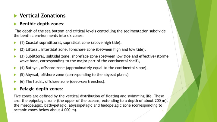
Vertical Zonations Benthic depth zones: The depth of the sea bottom and critical levels controlling the sedimentation subdivide the benthic environments into six zones: (1) Coastal supralittoral, supratidal zone (above high tide). (2) Littoral, intertidal zone, foreshore zone (between high and low tide), (3) Sublittoral, subtidal zone, shoreface zone (between low tide and effective/storme wave base, corresponding to the major part of the continental shelf), (4) Bathyal, offshore zone (approximately equal to the continental slope), (5) Abyssal, offshore zone (corresponding to the abyssal plains) (6) The hadal, offshore zone (deep-sea trenches). Pelagic depth zones: Five zones are defined by the vertical distribution of floating and swimming life. These are: the epipelagic zone (the upper of the oceans, extending to a depth of about 200 m), the mesopelagic, bathypelagic, abyssopelagic and hadopelagic zone (corresponding to oceanic zones below about 4 000 m). 1
Horizontal (surface) Zonation The lateral distribution of pelagic organisms with respect to their distance from the coast characterizes two major zones of the ocean: The neritic zone is the water that overlies the continental shelf, today generally with water depth less than 200 m and covering about 8% of the ocean floor. The oceanic zone the water column beyond the shelf break, overlying the slope and the deep-sea bottoms, generally with water depths greater than 200 m and down to more than 10 000 m. The depths are not compatible with the situation in many ancient oceans. 2
Basin axis: 1-Basin axis: a line connecting the lowest structural points of the basin, as in a synclinal axis, similarly the axes of troughs may be plunge. 2-topographic axis: a line connecting the lowest topographical points of the basin. 3-Depocenter axis: the part of the basin with the thickest sedimentary fill, this axis may migrate along basin with time. These axes above are not coincide with each other, particularly in asymmetric basins with large amounts of terrigenous sedimentation on the uplifted limb. wheras in gently subsiding basins, with pelagic fine-grained and turbidite fill, depocenter axis and topographic nadir may coincide. the depocenter moves across the basin in time. This may reflect a migration of the topographic axis of the basin, or merely a lateral progradation of the main depositional site across an essentially stable basin floor. 4
CONTROLS ON SEDIMENT ACCUMULATION 1-Tectonics of sedimentary basins: Plate tectonics provides a first-order control on sedimentation through its influence on the sediment source area. Tectonic forces control the type, size, shape, and location of the basins. Tectonic processes, together with sediment loading, further determine the rate of basin subsidence and thus the space available (accommodation) for sediment accumulation. The Tectonic processes controlling on creation of places (basins) where sediment accumulates ,range in size from a few kilometres across to ocean basins covering half the planet, with specific geomorphological feature, and may or may not be a place where sediment is accumulating and/or preserving. Without tectonics creating basins , there are no accumulation of sediment, no sedimentary rocks and no stratigraphy as we know it. 6
2-Connection to oceans and sea-level changes: Its clear at shallow marine environments, the sea level directly determines the amount of accommodation available for sediment to accumulate, but it also influences on fluvial deposition (continental) and deep sea sedimentation. Sea-level changes do not necessarily affect on basins that are wholly within continental landmasses and without link or direct exchange of water with the oceans, as lacustrine conditions, fluvial / aeolian processes in more arid climates. 7
3-Climatic effects of weathering, transport and deposition: Weathering processes are determined by the availability of water and the temperature (climate): under warm, humid conditions, more clay minerals and ions in suspension are generated, whereas colder environments form more coarse clastic material. The transport of sediment by water, ice or wind is also climatically controlled, through the amount of water available and the temperature. Depositional processes in all continental environments and many coastal settings are sensitive to the climate: a comparison of clastic lagoons formed in a temperate or tropical setting and an evaporite lagoon formed in an arid environment gives a clear importance of climate in determining depositional facies. 8
4-Bedrock and topography controls on sediment supply: The availability of sediment is principally determined by tectonic controls on uplift in the hinterland, but climate and bedrock character also play a role. Sediment supply is an important factor, in both, character and volume of material. The character of supplied sediment: It is obvious that a delta cannot be a site of deposition of sand if no sand is supplied by the river, and similarly, a deposit derived from the weathering /erosion of basaltic rock will have a very different character to one derived from a limestone terrain. The volume of sediment supply has an impact on the nature of the whole basin fill. -If the rate of sediment supply exceeds the rate of tectonic subsidence, the basin fills up (is overfilled) and the facies will be shallow marine or continental. -A low supply compared with subsidence rate results in a basin that is underfilled or starved: in a marine setting these basins will accumulate mainly deep-water facies. Continental basins that are underfilled may end up below sea level (e.g. the Dead Sea, Jordan, and Death Valley, USA). 9
The geologic record suggests that there have been many Wilson cycles in the history of each continent. Thus, few sedimentary basins remain unchanged with time, or in fixed positions, except perhaps some basins located on cratons well within continental margins. During the opening phases of a Wilson cycle, tectonic plates are moving apart (by rifting) to form divergent (passive) continental margins. The closing stages of a Wilson cycle are characterized by, plates moving toward each other, as oceanic crust is subducted (consumed) in trenches. Continental margins formed during ocean closing stage are called convergent (active) margins. During opening or closing of an ocean basin, some parts of plates may slide past each other without either diverging or converging. Such a setting is referred to as a transform margin. During a Wilson cycle, various kinds of sedimentary basins form in divergent, convergent, and transform settings, as well as in intraplate settings. 10

 Zonation")


