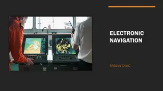
Pedestrian Navigation Challenges and Solutions

In the realm of pedestrian navigation, key issues such as map alignment, manual zooming, and context adaptation are explored to enhance user experience and efficiency. With the evolution of mobile computing, the need for personalized, context-aware information delivery becomes paramount. This lecture delves into the nuances of user interaction with maps, emphasizing the importance of dynamic adaptation to changing environments for optimal navigation outcomes.

Download Presentation

Please find below an Image/Link to download the presentation.
The content on the website is provided AS IS for your information and personal use only. It may not be sold, licensed, or shared on other websites without obtaining consent from the author.If you encounter any issues during the download, it is possible that the publisher has removed the file from their server.
You are allowed to download the files provided on this website for personal or commercial use, subject to the condition that they are used lawfully. All files are the property of their respective owners.
The content on the website is provided AS IS for your information and personal use only. It may not be sold, licensed, or shared on other websites without obtaining consent from the author.
E N D
Presentation Transcript
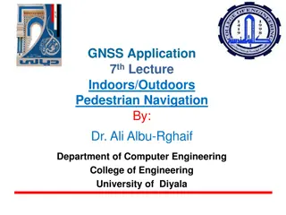
GNSS Application 6th Lecture Pedestrian Navigation By: Dr. Ali Albu-Rghaif Department of Computer Engineering College of Engineering University of Diyala
Outline Pedestrian Navigation Problem Statement Map Alignment with North Direction Manual Zooming and Static Map Extent Visualization of Personalized Information Daytime-Independent Landmark Visualization Context & Adaptation A Conceptual Model for Mobile Map Adaptation Adaptation Model Adaptation Operations
Pedestrian Navigation Computing has become increasingly mobile and pervasive, and the emerging technologies provide anytime/anywhere information. These changes imply that applications and services must be aware of and adapt to changing contexts in highly dynamic environments. A mobile user is potentially more distracted, and different constraints and limitations exist, such as small display, and limited energy and bandwidth. Users often need to make decisions on the spot and therefore require current personalized and context-sensitive information on their mobile devices, i.e, the presentation must be conditioned by the users activities and by the state of the world around them. A prime example is pedestrian navigation. Location Based Services and TeleCartography II
Problem Statement (1)Map Alignment with North Direction Most maps are aligned with the North direction. When using an analog map, users often turn the map around every few minutes or at every direction change, because this facilitates orientation. This is also true when using digital maps on mobile devices, which are aligned with the North direction. Therefore, one of the most useful pieces of context information is the user s walking direction, which could be measured by the Global Positioning System ( GPS) or different types of sensors Location Based Services and TeleCartography II
Problem Statement Map Alignment with North Direction Location Based Services and TeleCartography II
Problem Statement (2) Manual Zooming and Static Map Extent When using any nav. App. the user has to constantly change the map scale to get an overview of a larger area or a detailed view of an area of interest. In order to do this, the user must interact with the device by spanning a rectangle with the stylus on the screen. Some experience and skills are needed to get the correct map scale with this technique. In general, it is not known how to fit maps on small screens and which technique is best. Therefore, zooming at decision points is one important aspect of the model presented in this work. When the user reaches a decision point an automatic zooming function delivers a detailed view. Location Based Services and TeleCartography II
Problem Statement (3) Visualization of Personalized Information In application the user gets information about the POIs the service calculates for the tour. This means that the user only gets information about interesting locations for the current tour. Such information about short-term interests is not visualized automatically, but through direct interaction with the context menu of the service. The user has no facility to determine and set personal long-term interests, e.g., through preference settings via a user profile. Location Based Services and TeleCartography II
Problem Statement (4) Daytime-Independent Landmark Visualization People make use of salient objects in the environment to orient themselves and navigate through space. Application should provide landmark-based navigation instructions using point landmarks at decision points. Location Based Services and TeleCartography II
Context & Adaptation Context The dynamic changes of service and user states cause a change in context, and therefore context-awareness is an important factor in mobile computing. Several definitions for mobile computing regard context as the changing execution environment, which is divided into computing (e.g., computation resources), user (e.g., social situation), and physical environment (e.g., weather). Context is any information that can be used to characterize the situation of an entity. An entity is a person, place, or object that is considered relevant to the interaction between a user and an application, including the user and applications themselves. Location Based Services and TeleCartography II
Context Advantages of Context First, if a piece of information can be used to characterize the situation of the user or task, then this information is context. Location and time are examples of useful information within the model. Second, the definition allows for context to be either explicitly or implicitly indicated by the user. For example, the location of nearby objects can be detected implicitly by the service or explicitly through user input. These aspects build the basis for context-aware computing the ability of a mobile user s applications to discover and react to changes in the environment they are situated in. Location Based Services and TeleCartography II
Context & Adaptation Adaptation One of the goals of LBS should be to take up as little of the user s attention as possible. There are mechanisms available to fit the services to the current situation and make them flexible, called adaptation. Adaptation is therefore the answer to a changing context. There are two ways of achieving knowledge sharing between a service and its user making the service adaptive or adaptable Location Based Services and TeleCartography II
Adaptation Difference between Adaptive and Adaptable Adaptive Adaptable Dynamic adaptation by the service to current task and user User changes functionality of the service Definition Little (or no) effort by the user Strengths User is in control Weaknesses Loss of control User must do substantial work Location Based Services and TeleCartography II
A Conceptual Model for Mobile Map Adaptation Design Considerations The main hypothesis is that a formal model for mobile map adaptation predicts a reduction of user interaction and cognitive load during location- based tasks. 1) What is the user s task? 2) What are the user s requirements, needs, and preferences? 3) Which context features are needed for the task and satisfy the user s preferences? 4) Which kinds of operations are needed, so that the user can successfully accomplish the task? Location Based Services and TeleCartography II
A Conceptual Model for Mobile Map Adaptation Reduction of Cognitive Load Cognitive load can be understood as the amount of work needed to acquire and use information. In the case of mobile pedestrian navigation services this corresponds to the visualized information and navigation instructions displayed on the screen. The cognitive load theory (CLT) offers designers of different services a way of assessing and affecting some critical components during the design process of digital maps. Location Based Services and TeleCartography II
Adaptation Model The AdaptationModel (A) is composed of three submodels the ContextModel (C), the UserModel (U), and the TaskModel (T). These models are classified into dynamic and static elements. The ContextModel represents the dynamic elements of the model, because in most cases the Situation (S) of using a mobile device implies that the surrounding context changes (e.g., the user s position), whereas the user and the task remain the same. The ContextFeatures (cf) underlie dynamic actions and are always available in an explicit form, because they can be sensed by the device (e.g., position through GPS) or derived through other ContextFeatures. Their values change each time a Situation changes. In contrast to the TaskModel, both the ContextModel and the UserModel consist of different categories, and each category consists of an arbitrary number of features (e.g., the ContextModel consists of a context-category cc1 with features cf1,...,cfn) Location Based Services and TeleCartography II
Adaptation Model Location Based Services and TeleCartography II
Adaptation Model The ContextFeatures in the ContextModel describe the user s current situation with its various characteristics corresponding to the real world. The service s representation of the user is incorporated through a UserModel that describes the user with predefined information about the preferences. This information is represented by the UserFeatures (uf1, ..., ufn). These features represent all characteristics, which fall under the identity category of the context definition. One of the most challenging parts of the AdaptationModel is accounting for the user s purpose of using the map. The task mainly affects the determination of adaptive and adaptable operations based on the ContextFeatures and UserFeatures. Location Based Services and TeleCartography II
Adaptation Model Task-dependent activities to reach the goal Location Based Services and TeleCartography II
Adaptation Operations The system designer is responsible for deciding which operations are required (task dependent) and how they should behave (adaptive or adaptable). The determination of the ContextFeatures and UserFeatures for each operation is shown in table below. The TaskFeatures are not listed as input parameters for the operations; although they affect the kinds of operations, they do not deliver explicit features as input parameters for them. ContextFeature Time UserFeature Time-Range Operation Zooming MapExtent POIVis TrackUp LandmarkSwitching Position Velocity Direction Location Based Services and TeleCartography II
Adaptation Operations Operations for mobile map adaptation in pedestrian navigation services. Automatic zooming at decision points Location Based Services and TeleCartography II
Reference Location Based Services and TeleCartography II Springer-Verlag Berlin Heidelberg