Planning for Pedestrian & Bicycling Travel
Learn how to plan effectively for pedestrian and bicycling travel in your community, involving people, professionals, and small project assistants. Discover why creating a plan is essential, who needs to be served, and how to engage various stakeholders for successful implementation."

Download Presentation

Please find below an Image/Link to download the presentation.
The content on the website is provided AS IS for your information and personal use only. It may not be sold, licensed, or shared on other websites without obtaining consent from the author.If you encounter any issues during the download, it is possible that the publisher has removed the file from their server.
You are allowed to download the files provided on this website for personal or commercial use, subject to the condition that they are used lawfully. All files are the property of their respective owners.
The content on the website is provided AS IS for your information and personal use only. It may not be sold, licensed, or shared on other websites without obtaining consent from the author.
E N D
Presentation Transcript
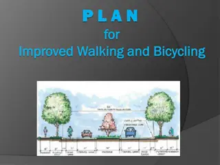
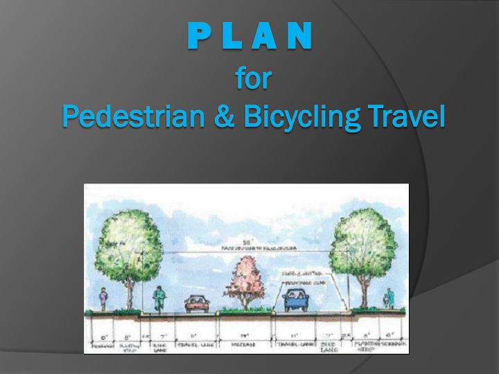
P L A N P L A N for for Pedestrian & Bicycling Travel Pedestrian & Bicycling Travel
Why do you need a plan for walkers? Why do you need a plan for walkers? They can walk anywhere, can t they? They can walk anywhere, can t they?
How to PLAN for Your Community How to PLAN for Your Community P L A N People/Professionals/Partners Locate Places on a Map Assess priority Network your plan
People and Places: People and Places: Connections Matter Connections Matter Connecting people to places via all possible modes of Transportation
PEOPLE: PEOPLE: Who needs to be served? Who needs to be served? Know the people who can benefit in your community Children Active walkers or runners Seniors College students People using canes, walkers or wheelchairs Tourists and visitors Local business patrons/owners Economically disadvantaged You and me
PEOPLE (The Professionals): PEOPLE (The Professionals): Planning Committee Members Planning Committee Members Know the people who can help with planning in your community Local/Regional Health Departments & Hospitals Development Chamber of Commerce Cooperative Extension Local Citizens, Parents, Business Owners City/County Officials, Planners and Engineers 1st Responders (Police, Fire, EMS) Area Development District Advocates
PEOPLE: PEOPLE: Small Project Assistants Small Project Assistants Know the groups or partners who can help with projects in your community Accomplish small projects such as area cleanups or bench building School groups Scout and 4-H groups Provide assistance with information gathering or project support Church groups Civic groups: Rotary, Civitan/Ruritan, Chamber of Commerce
PEOPLE: PEOPLE: Meeting with Your Committee Meeting with Your Committee Involvement + Coordination + Communication
How to PLAN for Your Community How to PLAN for Your Community P L Locate places on a map A Assess priority N Network your plan People and Places
LOCATE: LOCATE: Survey the Community for WHERE Survey the Community for WHERE METHOD WHO RESPONSES Online Survey Monkey Churches How many do you need? (Estimate) Schools Facebook Social Media How many did you get? (Actual) QR Code Local Business Door-to-door Postcard Paper-pencil Mobile App
LOCATE: LOCATE: Sample WHERE Survey Questions Sample WHERE Survey Questions For all or part of your trips to work, shopping, parks or other destinations, do you currently travel by foot? Yes (what percentage _____) No Are any of the following destinations within 2 miles of your home: workplace, shopping place, school or park? Yes (which ones?_________________________) No Please list the locations where pedestrian facilities need to be provided or improved: a) b) c)
LOCATE: Map the Focus Area LOCATE: Map the Focus Area Get a map (Google, ADD, Chamber of Commerce) Add or mark origin and destination points (homes, schools, recreation/par ks, businesses, etc.)
Working with Working with Russ Clark Russ Clark
LOCATE: LOCATE: Identify Local Priority Identify Local Priority Start small: zero in on an area of 4 to 6 blocks Consider community s goals, such as safety, connectivity, health, etc. Identify the area with input from your diverse planning committee and/or survey responses Economic Development Health Connectivity Safety
How to PLAN for Your Community How to PLAN for Your Community P L Locate Places on a map A Assess priority N Network your plan People and Places
ASSESS PRIORITY: ASSESS PRIORITY: Review Focus Area Data Review Focus Area Data Assess the community survey results Assess walkabilityin the focus area
ASSESS PRIORITY: ASSESS PRIORITY: What Does Your City Need? What Does Your City Need? Develop project(s) to respond to identified needs: Project must meet community goals Project reflects the results form the walkability/biking assessment Project must have a purpose and need statement
ASSESS PRIORITY: ASSESS PRIORITY: Customize for Your City Customize for Your City Prioritize plan items based on meeting community goals such as health, safety, mobility, connectivity, etc. Prioritize plan items with input from your diverse planning committee and/or survey responses Add the priority to the map
ASSESS ASSESSPRIORITY: PRIORITY: Use Other Communities for Examples Use Other Communities for Examples The KYTC Bicycle & Pedestrian program has links to numerous pedestrian and bicycle plans on its website for you to use as templates
ASSESS PRIORITY: ASSESS PRIORITY: Assemble Your Plan Assemble Your Plan Your plan should include: Discussion of community goals Process and criteria used to select focus area Process and criteria used to prioritize projects Short project description together with a Purpose and Need statement Summary map of all prioritized projects and individual project maps
ASSESS PRIORITY: ASSESS PRIORITY: Sample Plan Items Sample Plan Items Vision: Existing roadways and an abandoned rail bed are upgraded to allow safe pedestrian and bicycle connections through the Crestwood neighborhood. The project links to an existing overpass, offering commuters and school children safe crossing over Wilkinson Blvd. Project Specs: Total length: 3.25 miles Hard surface multi-use trail: 1.25 mile Marked road with sidewalks: 1 mile Bike lanes: 1 mile
ASSESS PRIORITY: ASSESS PRIORITY: Your Plan Priority Map Your Plan Priority Map
How to PLAN for Your Community How to PLAN for Your Community P L A N People and Places Locate Places on a map Assess priority Network your plan
NETWORK Your Plan: NETWORK Your Plan: Get Your Plan APPROVED Get Your Plan APPROVED Plan Success = Approval By Local Officials! Talk it up in the community Committee member(s) discuss with local officials Take plan to city council/county fiscal court or other responsible local body for consideration Get a Resolution of Approval
NETWORK Your Plan: Publish NETWORK Your Plan: Publish Publish your plan: Put it on a public web page Provide the link to TROY and KYTC
NETWORK Your Plan: NETWORK Your Plan: Tell EVERYONE Tell EVERYONE Share your plan with: TROY /KYTC Bike Ped Program Office Planning staff at your Highway District Office Transportation planners at your MPO Transportation planners at your ADD ALL other local and regional government staff Other regional bike/ped groups/clubs Local colleges Anyone else you can think of
NETWORK Your Plan: Highway Plan NETWORK Your Plan: Highway Plan Ask the Transportation Planners (Highway District and ADD) to: Develop a Project Information Form so the project can be included in the next Highway Plan project prioritization process.
KYTC Pedestrian & Bicycle KYTC Pedestrian & Bicycle Travel Policy Travel Policy Adopted in 2002 Provides checklists for locations requiring accommodations for pedestrians or bicyclists The Kentucky Transportation Cabinet (KYTC) shall consider the accommodation of bicycles and pedestrians on all new or reconstructed state- maintained roadways.
Individual Project Planning Individual Project Planning The purpose & need Unique details for each location & existing conditions Identify possible issues Plan considerations/options available Justification for accommodation Examples (standard drawings or photos) & sources
Individual Project Planning Individual Project Planning Funding $$Sources Funding $$Sources FHWA -Transportation Alternatives Program USDOT-TIGER grants FHWA- CMAQ in Air Quality Areas Tourism Parks Departments KYTC-Paula Nye Grants for Bike/Ped (Safety, Education, Encouragement) Sell it a Foot at a Time Private individuals or organizations Corporate Sponsors
Individual Project Planning Individual Project Planning Project Purpose and Need: The pedestrian accommodation across the bridge on Malibu Drive over Hickman Creek near the junction with KY-1974 (Tates Creek Road) needs to be improved for both safety and connectivity. Local/regional Planning: Lexington/Fayette Urban County Bicycle and Pedestrian Master Plan: http://www.lexingtonky.gov/index.aspx?page=579 Lexington Greenways Map (Figure 1) / http://www.lexingtonky.gov/Modules/ShowDocument.aspx?documentid=1999 Page 62 & 69 identifies this area as a priority trail corridor / http://www.lexingtonky.gov/Modules/ShowDocument.aspx?documentid=2002 Existing conditions: CS-3605/Malibu Drive (MP 1.65-1.68) ADT is 4850 Posted speed limit is 35 MPH No paved shoulder, curb and gutter cross section Bicyclists Comfort Index (BCI) rating is a D Moderate use by pedestrians (Figure 2) Moderate use by cyclists (Figure 3) KY-1974/Tates Creek Road (MP 9.5) ADT is 28400 Posted speed limit is 45 MPH No paved shoulder, curb and gutter cross section Bicyclists Comfort Index (BCI) rating is a E Moderate use by pedestrians (Figure 2) Moderate use by cyclists (Figure 3)
Individual Project Planning Individual Project Planning Best: Construct a 5 foot (or wider) separated pedestrian facility across Hickman Creek (on the non-cardinal direction side) and provide a connection to the existing sidewalks at MP 1.64 on CS-3605 / Malibu Drive (see Figure 4) and provide a connection to the signalized crosswalks at MP 9.55 on KY-1974 / Tates Creek road (see Figure 5). Improve existing pedestrian facilities within project limits to current ADA standards (see Figure 5). Good: Construct a 5 foot (or wider) sidewalk across the bridge (both sides) with a 48 inch tall (minimum) barrier between this facility and the travel lane. Connect the sidewalk to existing sidewalks at MP 1.64 on CS-3605 / Malibu Drive (see Figure 4) and provide a connection to the signalized crosswalks at MP 9.55 on KY-1974 / Tates Creek road (see Figure 5). Construct and improve pedestrian facilities within project limits to current ADA standards (see Figure 5). Fair: Construct a 5 foot (or wider) sidewalk across the bridge (non-cardinal direction) and connect to existing sidewalks at MP 1.64 on CS-3605 / Malibu Drive (see Figure 4) and provide a connection to the signalized crosswalks at MP 9.55 on KY-1974 / Tates Creek road (see Figure 5). Construct and improve pedestrian facilities within project limits to current ADA standards (see Figure 5).
Individual Project Planning Individual Project Planning Figure 2 / Strava Heat Source Map (pedestrian activity) of the project area / http://labs.strava.com/heatmap/#15/- 84.49933/37.99256/gray/run
Individual Project Planning Individual Project Planning Public meetings Right-of-way Project design
Individual Project Planning Individual Project Planning Project funding Operations Maintenance Realistic time expectations
Individual Project Construction Individual Project Construction Project bids for construction work Pre-construction public notice signs along project area Phases of construction
Bike/Ped Planning Provides Bike/Ped Planning Provides Opportunity Opportunity
Questions? Questions?


:")