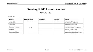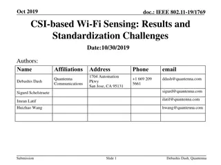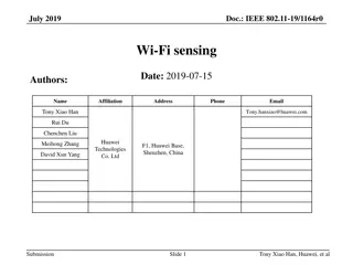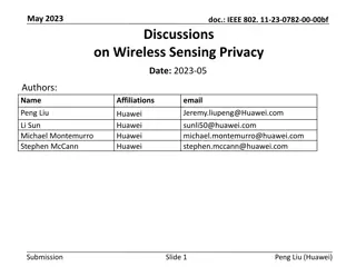
Remote Sensing Platforms and Sensors Overview
Explore the various orbits of remote sensing satellites and their advantages, including Low Earth Orbit, Sun Synchronous Orbit, and High Earth Orbit. Understand the different types of orbits and their applications in remote sensing technology. Discover how satellites pass over the Earth's surface, providing valuable data for environmental monitoring, meteorological observations, and more.

Download Presentation

Please find below an Image/Link to download the presentation.
The content on the website is provided AS IS for your information and personal use only. It may not be sold, licensed, or shared on other websites without obtaining consent from the author. If you encounter any issues during the download, it is possible that the publisher has removed the file from their server.
You are allowed to download the files provided on this website for personal or commercial use, subject to the condition that they are used lawfully. All files are the property of their respective owners.
The content on the website is provided AS IS for your information and personal use only. It may not be sold, licensed, or shared on other websites without obtaining consent from the author.
E N D
Presentation Transcript
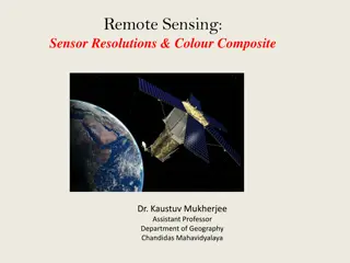
REMOTE SENSING PLATFORMS AND SENSORS Mr. Jogdand O. K. Department of Environment Sci. Deogiri College, Aurangabad
ORBITS OF REMOTE SENSING SATELLITE: Satellite is any object man made or natural that revolves around the earth TYPES OF ORBITS: Low Earth Orbit (LEO) < 2000 km Medium Earth Orbit (MEO) 2000-35786 km High Earth Orbit (HEO) > 35786 km
ORBITS OF REMOTE SENSING Low Earth Orbit: Polar orbiting satellites: Satellite is pass above the earth poles High resolution of images is possible Crosses the equator at 90
ORBITS OF REMOTE SENSING Low Earth Orbit: Polar orbiting satellites: The advantage is every time the satellite view the newer segment on the earth surface because of earth s rotation
ORBITS OF REMOTE SENSING Sun Synchronous Orbit Angle of inclination of the orbit with respect to the sun through out the year is same Always crosses equator precisely the same local sun time Mostly used for remote sensing the
ORBITS OF REMOTE SENSING Sun Synchronous Orbit
ORBITS OF REMOTE SENSING Near polar orbit Orbital plane inclined at small respect to rotational axis angle the with earth
ORBITS OF REMOTE SENSING High Earth Orbit Geo stationary orbit The satellite placed in this orbit is stationary with respect to the earth View the same area of the earth at all times View 50% surface (60 N to60 S) Orbital period is 24 hours of global
ORBITS OF REMOTE SENSING High Earth Orbit Geo stationary orbit Advantages : Useful for meteorological observation And also for commercial broadcast communication purpose and
ORBITS OF REMOTE SENSING High Earth Orbit Geo stationary orbit Dis-Advantages: Lowresolution Approximately size of 2.5 km ground Less information obtained a pixel on the is
ORBITS OF REMOTE SENSING Choice of orbit: It is dependent on the its mission Remote sensing satellites placed in LEO because it needs high resolution Commercial broadcast or Communication satellites are provided in HEO because it should receive and send signals from large geographical are
ORBITS OF REMOTE SENSING Shapes of orbits:
REMOTE SENSINGPLATFORMS Types of platforms : Ground basedplatforms Short range systems(50-100 m) Medium Range Systems ( 150-250 m) Long range Systems (up to 1 km) Airborne platforms Space-borne platforms
REMOTE SENSINGPLATFORMS Types of platforms : Ground Based Platforms: Mobile hydraulic platforms (up to 15 m height)
REMOTE SENSINGPLATFORMS Types of platforms : Portable Masts Unstable in windconditions
REMOTE SENSINGPLATFORMS Types of platforms : Towers: Greater rigidity thanmasts
REMOTE SENSINGPLATFORMS Types of platforms : Weather Surveillance Radar Detects and tracks typhoons and cloud masses
REMOTE SENSINGPLATFORMS Types of platforms : Airborne Platforms: Balloons based : Altitude range is 22-40 km Tool to probing the atmosphere Useful to test the instruments under development
REMOTE SENSINGPLATFORMS Types of platforms : Airborne Platforms: Radiosonde: Measure Temperature Relative the atmosphere Rawinsonde: Measure wind velocity, temperature, pressure and relative humidity pressure, and humidity in
REMOTE SENSINGPLATFORMS Types of platforms : Aircraft: Advantages: High spatial resolution (20 cm or less) Analog photography possible (analog gives high resolution) Easily change schedule weather problems Sensor maintenance and repair is easy is photo their avoid to
REMOTE SENSINGPLATFORMS Types of platforms : Aircraft: Dis Advantages: Permission to intrude into foreign airspace is required Many passes to cover larger area Swath is much less compare to satellite High cost per unit area
REMOTE SENSINGPLATFORMS Types of platforms : Space borne platforms: Sensors are mounted on-board a spacecraft Rockets , satellites and space shuttles Advantages : Cover large area Repetitive coverage of an area of interest
REMOTE SENSINGSENSORS Sensor : Common Definition : Sensors are Sophisticated devices thatare frequently used to detect and respond to electrical or opticalsignals A Sensor converts the Physicalparameter into a signal which can be measured electrically
REMOTE SENSINGSENSORS Sensor : Definition in Remote Sensing : Sensor is a device that gathers energy (EMR) converts into signal and present it into a signal and present it in a form (image) suitable for obtaining information about the objet under investigation
REMOTE SENSINGSENSORS TYPES OF SENSORS :
REMOTE SENSINGSENSORS Types of sensors : Active sensors: These sensors detect reflected from objects which are artificially generated energy sources Ex : Radar, camera with flash light Passive sensors: These sensors detect reflected EMR from naturalsource Ex : camera without flash light (depends on solar energy), and all RS sensors responses irradiated from
REMOTE SENSINGSENSORS Types of sensors : Non Scanning or Framing sensors: Measure the radiation coming from entire scene at once Ex: Our eyes, Photo cameras
REMOTE SENSINGSENSORS Types of sensors : Imaging sensors: Form image by collected radiation 1. Scanning sensors: The scene is sensed by point by point measure the coming from point by point (equivalent small areas with in the scene) Along track Scanners: Image is acquired by line by line or radiation to
REMOTE SENSINGSENSORS Types of sensors : Across track Scanners: Image is acquired by pixel bypixel
REMOTE SENSINGSENSORS Types of sensors : 2. Non imaging sensors: These sensors do not form the image These are used to record quantity or parameter as a function of time Ex: temperature measurement, study of atmosphere spectral
REMOTE SENSINGSENSORS Types of sensors : Image Plane Scanning: Lens is used after the scan mirror to focus the light detector on the
REMOTE SENSINGSENSORS Types of sensors : Object Plane Scanning: Lens is placed before the scan mirror to focus the light the detector on
CHARECTERISTICS OFSENSORS 1. Spatial resolution 2. Spectral resolution 3. Radiometricresolution 4. Temporalresolution
CHARECTERISTICS OFSENSORS Spatial resolution It refers to the size of the smallest possible object that can be detected It depends Instantaneous (IFOV) of the satellite height orbit It tells the pixel size on the ground surface on Field and the the Of View
CHARECTERISTICS OFSENSORS Spatialresolution
CHARECTERISTICS OFSENSORS Spatialresolution
CHARECTERISTICS OFSENSORS Spatialresolution
CHARECTERISTICS OFSENSORS Spectral resolution It describes the ability of a sensor to define fine wavelength ranges Sand is appear as coarser in finer wavelength bands
CHARECTERISTICS OFSENSORS Radiometric resolution It describes the ability of sensor to discriminate very slight differences in energy The number of brightness levels depends upon the number of bits used
CHARECTERISTICS OFSENSORS Radiometricresolution
CHARECTERISTICS OFSENSORS Temporal resolution It refers to how often it records imagery of a particular area, which means the frequency of repetitive coverage