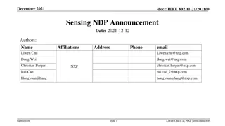
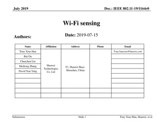
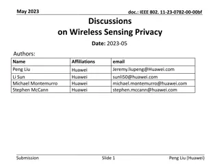
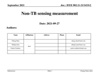
Remote Sensing Technology for Wildfire Support: Gaps & Opportunities
The Subcommittee on Disaster Response - Wildland Fire S&T Task Force focuses on enhancing community resilience to disasters through addressing six Grand Challenges. Explore the role of remote sensing technology in wildfire incidents, the need for tactical information for fire management teams, and the utilization of new sensors like Unmanned Aircraft Systems.

Download Presentation

Please find below an Image/Link to download the presentation.
The content on the website is provided AS IS for your information and personal use only. It may not be sold, licensed, or shared on other websites without obtaining consent from the author.If you encounter any issues during the download, it is possible that the publisher has removed the file from their server.
You are allowed to download the files provided on this website for personal or commercial use, subject to the condition that they are used lawfully. All files are the property of their respective owners.
The content on the website is provided AS IS for your information and personal use only. It may not be sold, licensed, or shared on other websites without obtaining consent from the author.
E N D
Presentation Transcript
Wildfire Support Remote Sensing Technology: Gaps & Opportunities Subcommitte on Disaster Response Wildland Fire S&T Task Force June 2014 Everett A. Hinkley National Remote Sensing Program Manager USDA Forest Service
Subcommittee on Disaster Reduction The Grand Challenges for Disaster Reduction outlines a ten-year strategy crafted by the National Science and Technology Council s Subcommittee on Disaster Reduction (SDR). It sets forth six Grand Challenges that, when addressed, will enhance community resilience to disasters and thus create a more disaster- resilient Nation.
Six Grand Challenges Challenge #1: Provide hazard and disaster information where and when it is needed. Challenge #2: Understand the natural processes that produce hazards. Challenge #3: Develop hazard mitigation strategies and technologies. Challenge #4: Reduce the vulnerability of infrastructure. Challenge #5: Assess disaster resilience. Challenge #6: Promote risk-wise behavior.
Wildland Fire S&T Task Force The Subcommittee on Disaster Response - Wildland Fire Science and Technology Task Force held a two- day planning meeting in August 2014 to discuss the best way forward to achieve the group s objectives as laid out in its charter. The Task Force has the end goal to identify opportunities and mechanisms for increased Federal coordination and cooperation to support the development, access, and application of science and technology before, during, and after wildfires.
Technology New Capabilities New Challenges Google Earth First Look 2004
Technology and Wildfire Wildfires Do response teams have sufficient tactical information to effectively and safely manage the incident? Work with fire management teams to identify gaps. Technology What is the role of RS technology in disasters/wildfire? Current RS capabilities: what do we currently bring to the fight? Can remote sensing technology be better applied to assist in decision-making, increase safety, and reduce losses? Are there underutilized technologies (identify opportunities)? New Sensors Unmanned Aircraft Systems Crowd Sourcing?
Wildland Fires - Requirements What Information is Needed? Fire detection and reporting / where are the starts? Fuel information what is available to burn? Weather - what are the current and predicted conditions? Need good forecasting And real time, high granularity weather information during event. Where is the active fire / what is the behavior? Fire perimeter and active fire fronts Where the fire has been (the black) Lines of containment Where are the firefighters? Assets at risk? People at risk? Update frequency? Data accuracy?
Wildland Fires - Technology (RS) Platforms Satellites Manned aircraft Unmanned aircraft Sensor s Thermal Sensors Weather Sensors Data Telemetry Capabilities Aircell Internet capability UAS radio repeaters Decision Support Tools Intelligent mission management technologies which take in data, analyze and then display the appropriate data to decision makers.
Technology - Sensors and Platforms Satellite MODIS Landsat NTM Other Airborne Phoenix Various (vendors) *Unmanned Airborne Systems: Ikhana / Global Hawk / Others Other Firehawk (active fire mapping) *Hawkeye (fire detection & alerting)
Hawkeye Fire Detection & Alerting Hawkeye leverages national systems for fire detection and alerting. In trial phase over past 2 fire seasons. Hawkeye has demonstrated a fire alert process with manual downgrade and dissemination of tipoff information. Hawkeye fire alerts have demonstrated a low false alarm rate, and proven early detection capability . Future capability may include automated fire detection and false alarm de-confliction based on the fusion of many divergent sources. All forensic case studies were very positive for Hawkeye fire alerts (i.e., good correlation between detections and actual fires in study areas). Hawkeye can support active fire monitoring, but additional requirements will require additional development work. 1
UAS Application Areas Wildfire Near real-time, high resolution fire detection and characterization Tactical scale imagery and geospatial mapping/visualization products Communications link/relay Resource Management General remote sensing hi res imagery, LiDAR and others . Forest inventory Resource mapping (fuels, forest health, etc.) Rangeland Monitoring (grazing permits) Law Enforcement & Investigations Surveillance Detection/mapping of illegal activities
Thoughts on UAS and Wildfire Integrating UAS into fire operations is complicated, but not impossible UAS augments manned aircraft capacity Expands the tool kit Transfer of technologies It s also about the mission objective, the sensor and related technologies Sensor characteristics Data and products Communications; Delivery and dissemination of data/products Data and intelligence derived using UAS can potentially increase the safety and effectiveness of firefighters
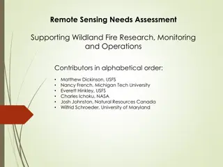
Tactical Fire Remote Sensing Advisory Committee (TFRSAC) Mission: Ensure that the WRAP program is supporting the firefighter s technology needs. Identify gaps & opportunities ; transfer capable technology and development applications to the Field. Membership: Stakeholders from NASA, USDA Forest Service, DOI Bureau of Land Management, Universities, and including Firefighters from 3 nations, with expertise in fire detection/mapping, aviation, communications, and ground operations. Next meeting: October 22 -23 / Reno NV
Technology and Disasters Closing Caveats Over-reliance on technology may: create a false sense of security create vulnerabilities and dull common sense in dangerous situations Technology can not make all of us safe all the time.
Contact Information Everett A. Hinkley National Remote Sensing Program Manager Senior Advisor to National Coordination Office for PNT Process Engineer / Plumber USDA Forest Service 703-605-4580 / ehinkley@fs.fed.us


")