Risk Assessment and Probability Modeling in Drone Terrorism
Addressing the security risks posed by drones, this content delves into Bayesian inference and risk models for assessing the threat of terrorist attacks using drones. Explore the implications and strategies to mitigate potential risks.

Download Presentation

Please find below an Image/Link to download the presentation.
The content on the website is provided AS IS for your information and personal use only. It may not be sold, licensed, or shared on other websites without obtaining consent from the author.If you encounter any issues during the download, it is possible that the publisher has removed the file from their server.
You are allowed to download the files provided on this website for personal or commercial use, subject to the condition that they are used lawfully. All files are the property of their respective owners.
The content on the website is provided AS IS for your information and personal use only. It may not be sold, licensed, or shared on other websites without obtaining consent from the author.
E N D
Presentation Transcript
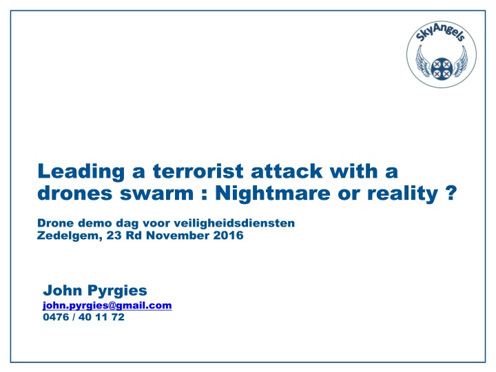
Leading a terrorist attack with a drones swarm : Nightmare or reality ? Drone demo dag voor veiligheidsdiensten Zedelgem, 23 Rd November 2016 John Pyrgies john.pyrgies@gmail.com 0476 / 40 11 72
Context The Riga declaration on drones, issued on 6 th March 2015, states : Drones also pose potential security risks. The design of drones can and should take into account those risks by using methods such as cyber-defence or geofencing. However, the malicious use of drones cannot be entirely prevented by design or operational restrictions . -> It is the task of the national police and justice systems to address those risks The Royal Military Academy has been requested by the Belgian Interior and Defense ministries to deliver an opinion about the potential risks represented by drones in the preparation or execution of a terrorist attack
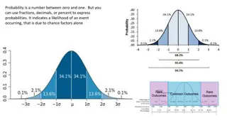
Bayesian inference Bayesian inference is a method used to update the probability for an hypothesis H as an evidence E is acquired according to : P(H | E) = P(E | H) . P(H) / P(E) Where : P(H) is the prior probability i.e. the probability of H before E is observed P(H | E) is the posterior probability i.e. the probability of H after E is observed and thus the probability that the hypothesis H verifies given the observed evidence E P(E | H) is the likelihood of observing E given H i.e. the compatibility of the evidence with the given hypothesis P(E) is the probability to observe E, independently of H Source : Wikipedia
Risk Model Risk = Threat Vulnerability Consequence Where : Threat = P(attack occurs | Signals) Vulnerability = P(attack results in damage | attack occurs) Consequence = E (damage | attack occurs and results in damage) Sources : Risk Analysis, Vol. 22, N 3, 2002. Fusion of Intelligence Information: A Bayesian Approach - Elisabeth Pat -Cornell, RAND - Center For Terrorism Risk Management Policy, 2005. Estimating Terrorism Risk Stanford University, Department of Management Science & Engineering, 2005. Risks of Terrorist Attacks, Probabilistic assessment and use of intelligent information - Elisabeth Pat -Cornell
Threat of an Attack The Threat of an Attack can be modeled according to : Threat = P(Attack Scenario | Signalsi) and represents the probability that an attack scenario is executed (hypothesis verifies) given a set of Signalsi (the observed evidence) An attack scenario is an attack launched against a specific target located in a specific geographic area with a specific weapon using a specific mean of delivery during a specific time period Sources : Risk Analysis, Vol. 22, N 3, 2002. Fusion of Intelligence Information: A Bayesian Approach - Elisabeth Pat -Cornell, RAND - Center For Terrorism Risk Management Policy, 2005. Estimating Terrorism Risk Stanford University, Department of Management Science & Engineering, 2005. Risks of Terrorist Attacks, Probabilistic assessment and use of intelligent information - Elisabeth Pat -Cornell
Targets type Symbolic monuments, Government buildings and representatives Business districts, skyscrapers, stock exchanges, hotels and casinos, airports, nuclear power plants Military, train and subway stations, stadiums, bridges and tunnels Industrial facilities, oil and gas processing facilities, tourist attractions, shopping malls, restaurants, ports and ships Media HQ, Fortune 100 HQ, theaters, major entertainment centers, gas stations Cruise ships, apartment buildings, foreign consulates, European institutions Water reservoirs and distribution, passenger trains, airspace zones Power plants, dams, railway networks Source : RAND - Center For Terrorism Risk Management Policy, 2005. Estimating Terrorism Risk
Geographic area All the countries of the European Union But France and Belgium are recurrently under the terrorist attacks from ISIS
Time period 6 months
Weapons type Explosive (ex TNT) Nuclear Biological (ex anthrax) Chemical (ex sarin gas) Radiological (ex Cesium 137) Firearms Air-to-surface missiles Source : RAND - Center For Terrorism Risk Management Policy, 2005. Estimating Terrorism Risk
Means of delivery Producer & Designation RPAS Type Max Payload (Kg) Range (Km) Endurance (H) Max Speed (Km/H) Price ( ) DJI Phantom 3 Micro < 0,2 2 0,383 57 < 1000 Draganflyer X8 Micro 0,8 1,5 0,33 50 > 30 000 Infotron IT180- 5TH Mini 5 10 2 90 > 60 000 Iran AMI Ababil- S Close Range 45 100 4 200 ? Source: Blyenburgh & Co - UVS - RPAS Yearbook 2015, 13 Th Edition + Producer web sites
Some Realistic RPAS Attack Scenarios RPAS Attack Scenarios Mean of Delivery RPAS Type Target Weapon Geographic Area Timeframe Summit with personalities (eg COP22, EU ) France, Belgium, Europe within 1 year Scenario 1 Micro Explosive Stadium (with mass gathered and personalities) Chemical/Biologica l France, Belgium, Europe within 1 year Scenario 2 Micro National day parade (with mass gathered and personalities) France, Belgium, Europe within 1 year Scenario 3 Micro Explosive within 1 year Scenario 4 Micro Airport (jetliner) Explosive Europe Ports and ships (eg gas tanker in Antwerp within 1 year Scenario 5 Mini Explosive Europe
Attractivity for terrorists Attractivity attack vector: Hit very protected personalities (EU summit) Hit masses protected by a security perimeter (Euro football match) Hit very protected personalities AND masses (national day parade) Symbolic Aspect coalition drones attacks with drones of drones swarm as an : ISIS retaliates
Signals Signals1 (2015) : Illegal drone flights over Paris and (nuclear plants, submarine bases ) in France and Belgium strategic sites Signals2 (May 2016): Commercial micro- drones transformed Improvised Explosives Devices (IED) discovered in captured by coalition forces into flying ISIS arsenals Signals3 (October drone has French paratroopers at Erbil (Irak) 2016): An seriously ISIS IED wounded 2 Sources: Bloomberg News 7 Th July 2016 Le Monde 11 Th October 2016 Photo Nouvel Obs
Other Possible Attack Scenarii Attack Scenarios Mean of Delivery Target Weapon Geographic Area Timeframe Oil and gas Processing within 1 year Scenario 6 Pedestrian Explosive Europe Government building within 1 year Scenario 7 Pedestrian Fireams Europe within 1 year Scenario 8 Car Airport Explosive Europe Drones can be used by terrorists to prepare those conventional attacks as they could exploit this new way of performing reconnaissance activities One shall assess : P(Attack Scenarioi | Reconnaissance by drone)
Countermeasures Countermeasures are the technological and organizational means Decreasing launched (deterrence) the probability the attack is Threat = P(attack occurs | Countermeasures) Decreasing the probability the attack succeeds Vulnerability = P(attack results in damage | Countermeasures) Limit the damages to an acceptable level Consequence = E (damage | Countermesures)
Countermeasures Detection : One or several drones are approaching a protected asset Classification : Identify : Friend or foe ? What type of drones ? (What type of payload ?) Tracking : Follow up their trajectory Interception : Act on them to protect their target AND avoid collateral damages
Detection : Radars Conventional radars used in Air Traffic Management are not well suited to follow small, low flying, slow motion aircrafts like drones Doppler Radar with electronic scanning Frequency Modulated Continuous Wave (FMCW) using a Passive Electronically Scanned Array (PESA) and operating on the KU band. Can be combined in multi-radars operations. Detects a Micro drone at ranges up to 2 KMs (Blighter A400 Series) Doppler Radar operating on the X band. Can be combined in multi- radars operations (Kelvin Hughes SharpEye) Doppler Radar operating on the X band with Frequency Modulated Continuous Wave (FMCW). Can be combined in multi-radars operations (Robin Elvira) Radar with Frequency Modulated Continuous Wave (FMCW). Detects a Micro drone at ranges up to 5 KMs (Thales Squire) Source: Blighter, Kelvin Hughes and Robin
Detection : Other technologies Acoustic detection : Recognizes unique sound patterns of common drones types. Detects a Micro drone at ranges up to 1 KM. Not suitable to noisy urban environments (Droneshield, Drone Detector) Thermal detection : Electric micro drones do not produce a lot of heat (Drone Detector) Radio frequency detection : Allows to detect the signals emitted by the radio controller (commands) and the drone (telemetry). Detects a Micro drone at ranges up to 0,5 KM (Drone Detector) Source: Drone detector
Classification : Cameras Electro optical color camera : integration of multiple cameras, target classification based on color codes (Kelvin Hughes SharpEye, Chess) Thermal imaging camera: Suitable for drones flying in bad weather conditions or in the darkness (Kelvin Hughes SharpEye, Chess) Source: Kelvin Hughes, Blighter
Good Drones identification Real time flight tracking solutions: Unifly (BE), Dron House (PL) allows to identify the good drones and provide their real-time position to aviation authorities Police forces are thus in a better position to identify potentially hostile drones as they have no recorded flight plan Sources: Unifly, Dronhouse
Tracking : Video tracking Video tracking technology tracks the trajectory of the drone. Track fusion from multiple (Kelvin Hughes hypercable Vidoc, Chess) sources SharpEye, Source: Kelvin Hughes, Hypercable
Interception : RF Signals jamming Disrupt the signals exchanged between the remote controller and the drone via the C2 link (Hypercable, Enterprise) Triggers the Return To Home function of the autopilot No effect on a drone flying an automatic mission with waypoints programmed in its autopilot and stored in its embedded memory and without connection to its remote controller Source: Hypercable, Blighter
Interception : GNSS Signals jamming Disrupt the GNSS signals reception by the drone (Enterprise , part of Blighter AUDS solution) Depending on drone models: Triggers the Return To Home function of the autopilot Make it hoover or crash Source: Blighter
Interception : GNSS Signals spoofing Emit false GNSS scenarios (set of coherent signals) and mislead the drone into believing it is at an other location GPS, Glonass and Beidou constellations Range 2 To 100 KMs (Hypercable Clearsky coupled with the Bromur turret) Can affect all rogue drones part of a swarm ! There are researches to allow drones navigating without GNSS (camera which recognizes landmarks and maps stored in the embedded memory of the drone, development of drones IMU ) Source: Hypercable
Interception : AA technologies Use Anti Aircraft (AA) Weapons to shot the drone down (50 mm drone killing Bushmaster cannon - fragmentation head, Thales Rapidfire cannon) Use an Anti Aircraft infrastructure with High Energy Lasers (HEL) able to destroy a complete swarm of drones (Rheinmetall)
Interception : Other technologies Capture the rogue drone with a net shoot from a portable bazooka (SkyWall 100) Capture the rogue drone with a net shoot from a from another drone (Excipio) Capture the rogue drone with a Royal eagle (Dutch police)
Approach proposed by SkyAngels To effectively drones The solution is a swarm of cooperative and autonomous drones neutralize efficiently swarm and a of terrorist That emit false GNSS scenarios with GNSS spoofers over the hostile drones to safely guide them to secure areas where their payload could explode And that are launched from drones carrier airships drones detection equipment that also carry Sources: Hypercable ClearSky GNSS Spoofer - LTA airstation UAS Carrier system from AIAA Lookheed Martin hybrid airship
The challenges for the authorities Integrate drones attacks in their risk model and keep it up-to-date : Threat = P(drone attack occurs | Signals) Vulnerability = P(drone attack results in damage | attack occurs) Consequence = E (damage | attack occurs and results in damage) and select and implement the most effective and efficient countermeasures : Threat = P(drone attack occurs | Countermeasures) Vulnerability = P(attack results in damage | Countermeasures) Consequence = E (damage | Countermesures) Sources : Risk Analysis, Vol. 22, N 3, 2002. Fusion of Intelligence Information: A Bayesian Approach - Elisabeth Pat -Cornell, RAND - Center For Terrorism Risk Management Policy, 2005. Estimating Terrorism Risk Stanford University, Department of Management Science & Engineering, 2005. Risks of Terrorist Attacks, Probabilistic assessment and use of intelligent information - Elisabeth Pat -Cornell
Next steps Collect stakeholders requirements and formalize them in a Product Requirements (what is an anti hostile drones solution ? ) Architecture design and technical feasibility of the solution (how to build it ?) Financial aspects : Investments, operating costs and revenues (Business case) Find public and private sector partners Document