River Network Analysis and Erosion Modeling in Eastern Himalayas
Explore the methodology of stream network extraction, knick point deduction, bedrock incision analysis, and erosion rate calculation using stream power incision models in the Eastern Himalayas. Discover how river profiles and erodibility coefficients are calculated and interpreted for geomorphological studies.

Download Presentation

Please find below an Image/Link to download the presentation.
The content on the website is provided AS IS for your information and personal use only. It may not be sold, licensed, or shared on other websites without obtaining consent from the author. If you encounter any issues during the download, it is possible that the publisher has removed the file from their server.
You are allowed to download the files provided on this website for personal or commercial use, subject to the condition that they are used lawfully. All files are the property of their respective owners.
The content on the website is provided AS IS for your information and personal use only. It may not be sold, licensed, or shared on other websites without obtaining consent from the author.
E N D
Presentation Transcript
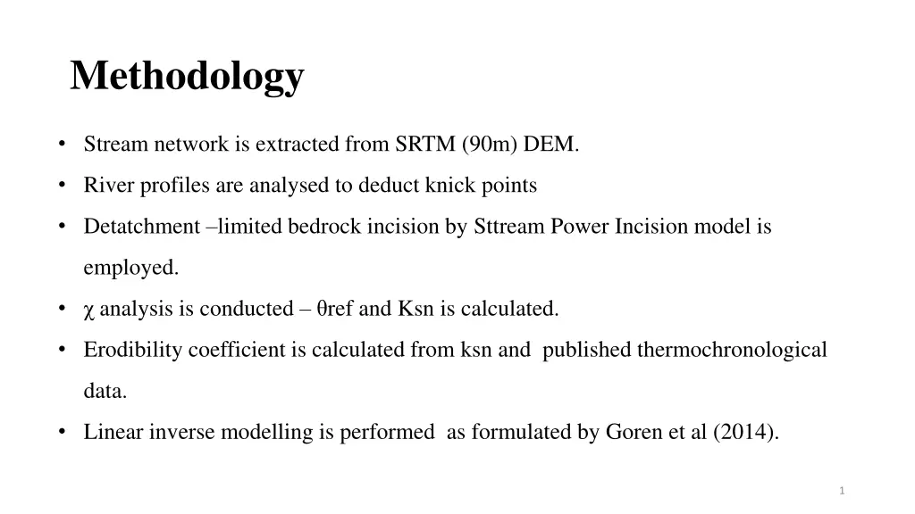
Methodology Stream network is extracted from SRTM (90m) DEM. River profiles are analysed to deduct knick points Detatchment limited bedrock incision by Sttream Power Incision model is employed. analysis is conducted ref and Ksn is calculated. Erodibility coefficient is calculated from ksn and published thermochronological data. Linear inverse modelling is performed as formulated by Goren et al (2014). 1
Stream Power Incision law Detatchment limited stream power incision law is employed as erosion is milnly limited by the incision of river channel into the bedrock in Eastern Himalayas ? = ????? .. (1) where E is the erosion rate(m/yr), A is the upstream drainage area, S is the channel slope, K is the erodibility coefficient, which is a measure of the efficiency of the incision process, and m and n are constant exponents depending on basin topography 2
Stream Power Incision law Combining the mass conservation equation ? . (2) ??(?,?) ?? ??(?,?) ?? = ? ?,? ??(?)? Z is the river channel elevation, and U is the uplift rate of the bedrock. For steady-state when dz/dt =0 1 ??(?) ? ? . .(3) ?? ??=? ? (Howard, 1994; Whipple & Tucker, 1999; Adams and K. X. Whipple, 2016) 3
Stream Power Incision law Thus, for the channel slope and basin area can be related as ? = ??? ? . (4) 1 ? =? ? ? ? ??? ??= Where is the concavity index, and ks is the steepness index, (Howard, 1994; Whipple & Tucker, 1999; Adams and K. X. Whipple, 2016) 4
River Profile Analysis Longitudinal profile Two kinds of Knick points- vertical step knick points due to variation in lithology slope-break knickpoints due to tectonic activity Knick points of tectonic origin- high ksn variations Tall knick points- indicates sudden uplift or base level fall . 5
analysis On integrating both sides of (2) ? ?(?) = ???0 When plotted by assuming ?0= 1 m2,gives z- ? plot called chi plot. ? ?dx ..(6) ??(?) (5) ? ?0 ?(?) = 0 ? ? The analysis is useful in determining the drainage characteristics as it shows a linear plot for steady state system Any deviation can be attributed to the transient characteristics of the drainage network. (Perron &Royden, 2013) 6
Erodibility Coeffcient The erodibility coefficient can be calculated using ? ??? ..(8) ? = Due to unavaialability of erosion rates the denudation rates from the thermochronolgical study conducted by Lupker et al(2017) in the Siang basin is used to find K. The denudation rates for the Siang basin ranged between 0.1-0.9. Maximum denudation rate of 0.9 is used to calculate K. 7
Linear Inverse Modelling The time taken by a perturbation signal to travel along the river channel from the outlet to a point x is called response time given by ? ?? ??(?) ??(? )? 1 ..(9) ?(?) = 0 with a linear relationship given by ?(?) =?(?)/? Present river elevation of the river can be expressed as 0 ? (? )dt (10) where ? = ??0 ? ? = ?(?) ?? ? = ? ??? ..(11) 8
Linear Inverse Modelling Eastern Himalayas -the region exhibits spatially uniform uplift for different structural zones ( Seward & Burg, 2008)- Block uplift conditions are applied N measurements of z and is arranged as a matrix given by, ? ? = z .. (12) where q represents ? intervals (A*= N x q matrix). The least-square estimate of ? is + (? ?? + ???) ?? ?(? ? ???? ) .. (13) ? = ???? . ? ?(??/ ?=? ? ?,?) is the adjusted uplift rate( =dampening coefficient, and I where ???? =qx q identity matrix). (Goren et al., 2014). = ?/? ?=? 9
Linear Inverse Modelling A step plot for the uplift is obtained- showing uplift occurs at different phases with the rate remaining constant for a particular time period before it changes to a new value. The uplift pattern is compared with the published exhumation rates and is found to coincide with the exhumation peaks for Namche Barwa Syntaxis and Siang antiform. 10
References Adams, B. A, and &K. V. Hodges, K. X. Whipple. 2016. In situ development of high-elevation, low-relief landscapes via duplex deformation in the Eastern Himalayan hinterland, Bhutan. J. Geophys. Res. Earth Surf., Goren, L., Fox, M., & Willett, S. (2014). Tectonics from fluvial topography using formal linear inversion: Theory and applications to the Inyo Mountains, California,. J. Geophys. Res. Earth Surf., 119, 1651 1681. Howard, A. D., & Kerby, G. (1983). Channel changes in badlands. Geological Society of America Bulletin, 94(6), 739-752.DOI: 10.1130/0016-7606(1983)94739:CCIB2.0.CO;2 Lupker, M.,Lav , J.,France-Lanord, C., Christl, M., Bourl s, D., Carcaillet, J.,Maden, C. Wieler, R., Rahman, M., Bezbaruah, D., Xiaohan, L. (2017). 10Be systematics in the Tsangpo- Brahmaputra catchment: the cosmogenic nuclide legacy of the eastern Himalayan syntaxis. 10.5194/esurf-2017-18. Perron, J., & &Royden, L. (2013). An integral approach to bedrock river profile analysis. Earth Surf. Process. Landforms, 38, 570-576. Whipple, K. X., & Tucker, G. E. (1999). Dynamics of the stream power river incision model: Implications for height limits of mountain ranges, landscape response timescales, and research needs. Journal of Geophysical Research: Solid Earth, 104(B8), 17661-17674. 11
Thank You 12