Satellite Instrument Calibration on GEO & LEO Orbits
Workshop on calibration practices for satellite instruments in different orbits, focusing on cross-calibration and calibration opportunities between small and large satellites. Includes discussions on orbits for environmental satellites and calibration techniques for optical remote sensing.

Download Presentation

Please find below an Image/Link to download the presentation.
The content on the website is provided AS IS for your information and personal use only. It may not be sold, licensed, or shared on other websites without obtaining consent from the author.If you encounter any issues during the download, it is possible that the publisher has removed the file from their server.
You are allowed to download the files provided on this website for personal or commercial use, subject to the condition that they are used lawfully. All files are the property of their respective owners.
The content on the website is provided AS IS for your information and personal use only. It may not be sold, licensed, or shared on other websites without obtaining consent from the author.
E N D
Presentation Transcript
Calibration of Satellite Instrument on GEO & LEO Orbit Xiangqian Wu NOAA/NESDIS/STAR
Background Workshop to share the best practices in GEO & LEO calibration. As the 3rdin a series by Earth Resources Observation and Science (EROS) Cal/Val Center Of Excellence (ECCOE). Cross-calibration of Landsat and Sentinel 2. Calibration opportunities between small and large satellites. Preceding the annual Joint Agency Commercial Imagery Evaluation (JACIE) workshop Meteorologist working for NOAA as Instrument Scientist (operational calibration) for AVHRR on POES Imager and sounder on GOES Advanced Baseline Imager (ABI) on GOES 2019-09-23 ECCOE Workshop, Reston, VA 2
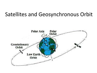
Orbits for Environmental Satellites LEO One instrument Big difference from calibrating thousands of radiosondes made by dozens of manufactures from hundreds of countries. views the entire earth Required by numerical weather prediction (NWP) under identical illumination Important in early days when VNIR applications dominated from close distance. Less remote comparatively. GEO Frequent (8-2880 times/day) observations over larger area simultaneously . Not global coverage 2019-09-23 ECCOE Workshop, Reston, VA 3
More On Orbit LEO: Low Earth Orbit Polar: Inclination angle = 90 Pole to pole to cover the earth Sun-synchronous: Inclination angle = ~98 that, combined with the flattening of the earth, generates orbit precession to compensate for the difference between sidereal and solar days. Not exactly polar , therefore no longer entire earth . GEO: Geosynchronous Equatorial Orbit Geosynchronous: orbit period = sidereal day Not solar day Geostationary: A special geosynchronous orbit with eccentricity = 0 and inclination angle = 0. Deviation from these results in analemma Other Designed to sample diurnal variation (ERBS, TRMM) Other applications (GPS, tundra) 2019-09-23 ECCOE Workshop, Reston, VA 4
Satellite Instrument Calibration Optical remote sensing How much radiance (radiometric calibration) From where (spectral and geometric calibration) Spectral calibration (spectral response function or SRF/RSR, polarization) is primarily pre-launch. Geometric calibration (geo-location, co-registration) is omitted in this talk. Radiometric calibration: Determine instrument response to known signal under selected conditions such that its response to all signals under expected conditions can be known sufficiently. Not merge or harmonization or homogenization etc. 2019-09-23 ECCOE Workshop, Reston, VA 5
Orbit and Calibration AVHRR housing temperature for NOAA-19 & METOP-A 1 K 2019-09-23 ECCOE Workshop, Reston, VA 6
Orbit and Calibration Imager scan mirror temperature for GOES-12. 40K-60K daily, more rapid during heating Seasonal variation of diurnal change Long term trend 2019-09-23 ECCOE Workshop, Reston, VA 7
Calibration Implications of Orbit Selection Thermal stress LEO enjoys relatively fixed and favorable illumination geometry For GEO, heating changes daily and seasonally, and is always intense around satellite midnight. 1stgeneration GEO ( spinners ) are largely spared of this. GOES 1-7, GMS 1-5, METEOROSAT 1-7 & 8-11, FY-2 A-H. But they have other challenges, e.g., partial optical calibration This has profound impacts to instrument calibration, radiometrically, geometrically, and in the case of GOES-17, even spectrally. Some manifest themselves in unexpected ways. Stray light around GEO midnight Not totally immune to LEO, but a lot easier to handle. Space environment Magnetopause was compressed below the GEO orbit recently. Navigation Jitter due to magnetometer boom and rotating solar panel Alternative to geolocation (rectification vs. navigation, Kalman filter) 2019-09-23 ECCOE Workshop, Reston, VA 8
Operational Calibration at NOAA Instrument calibration and product (radiance) validation are both important, in their own rights and to each other. Cal/Val are closely related but applied to different objects. Both must be monitored in near real time and for mission life. For resolution of anomalies and communication with stakeholders. Typical anomaly resolution procedure, for GEO & LEO. Detection and/or confirmation Characterization Root cause Investigation Evaluation of mitigation options Implementation Verification Communication Documentation 2019-09-23 ECCOE Workshop, Reston, VA 9
Inter-Calibration 2004: Simultaneous Nadir Overpass (Cao) Pioneer in inter-calibration. 2006: Global Space-based Inter-Calibration System (GSICS) Sponsored by WMO All meteorological satellite operators + other members A critical tool for ABI calibration. Many works before and after Inter-calibration of METEOSAT & GOES using AVHRR. Unfinished, but the lessons learned led to the change in 2004 the ABI VNIR SRF to be as similar to VIIRS as possible. 2019-09-23 ECCOE Workshop, Reston, VA 10
Inter - Calibration Premise: Two instruments should produce identical measurements when they view a target At the same time; Over the same region; From the same angle; and With the same spectral responses. None is likely to be true in reality, so one must minimize these effects and account for them properly in analysis. This is not calibration unless one is considered truth. The true value of inter-calibration is not (necessarily) that one is better but their errors (if any) are independent. Inter-calibration with GEO, LEO, RTM, and so forth. 2019-09-23 ECCOE Workshop, Reston, VA 11
Capabilities and Opportunities Calibration capabilities: Accuracy of concurrent (same generation) GEO and LEO instruments are comparable. VISSR, MVIRI, Imager, SEVIRI, S-VISSR vs. AVHRR. ABI, FCI vs. AIRS, IASI, CrIS, VIIRS Some challenges remain for GEO VNIR channels. GEO instruments may have a little higher noise, but not by much. Navigation is comparable in terms of pixel size. Opportunities to help each other: GEO views large area with small difference in angles. Can evaluate LEO s angular dependence. GEO can be a transfer radiometer for all LEO SNO sampling is much limited in space and time. Massively expand inter-calibration and use AI (starting with automated alert) to monitor a web of sensors. 2019-09-23 ECCOE Workshop, Reston, VA 12