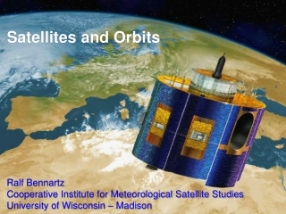
SEARCH AND RESCUE SATELLITE AIDED TRACKING (SARSAT)
The Cospas-Sarsat program plays a crucial role in search and rescue operations by providing accurate distress alert and location information globally. Beginning with the development of emergency beacons in the 1950s to the operationalization of the 406 MHz beacon technology, the history and significance of SARSAT in saving lives are highlighted. With services offered free of charge for users in distress worldwide, the system ensures timely alerts and coordination with search and rescue authorities using satellite and ground systems. The cooperation among countries and the evolution of beacon technologies demonstrate a commitment to enhancing safety and facilitating swift responses to emergencies.

Download Presentation

Please find below an Image/Link to download the presentation.
The content on the website is provided AS IS for your information and personal use only. It may not be sold, licensed, or shared on other websites without obtaining consent from the author.If you encounter any issues during the download, it is possible that the publisher has removed the file from their server.
You are allowed to download the files provided on this website for personal or commercial use, subject to the condition that they are used lawfully. All files are the property of their respective owners.
The content on the website is provided AS IS for your information and personal use only. It may not be sold, licensed, or shared on other websites without obtaining consent from the author.
E N D
Presentation Transcript
SEARCH AND RESCUE SATELLITE AIDED TRACKING (SARSAT)
Introduction History User Segment Space segment Use of GPS in Location Protocol Beacons LEOSAR and GEOSAR systems Advantages/Disadvantages of each system USMCC and SAR Future of SARSAT
Introduction COSPAS = COsmicheskaya Systyema Poiska Aariynyich Sudov Which loosely translates into: The Space System for the Search of Vessels in Distress SARSAT = Search And Rescue Satellite Aided Tracking
Introduction It s about saving lives - The Cospas-Sarsat Program protects life and property by providing accurate, timely, and reliable distress alert and location information to search and rescue authorities. - In short, Cospas-Sarsat works to take the search out of Search & Rescue
Introduction - Services are provided world-wide and free of charge for the user in distress - Alerts are provided using satellite and ground systems to detect, process, and relay the transmissions of emergency beacons operating on 406 MHz
History - First beacons were 121.5/243 MHz Emergency Locator Transmitters (ELTs) designed for military aircraft in the 1950 s. - U.S. Congress mandated ELTs on all U.S. aircraft after Boggs-Begich tragedy in SE Alaska in early 1970 s. Canada follows suit. - Problems soon emerge: No identification of aircraft/beacon Designed for audible detection by over-flying aircraft No means of accurately locating ELTs
History 1978: Canada, France and the USA agree to co-operate on the development of the SARSAT low-altitude polar orbiting system to: Locate existing 121.5 MHz beacons Develop a new technology for improved performance = 406 MHz - Russia declares its interest in co-operating with the objective of ensuring inter-operability of their COSPAS system with SARSAT. - Cooperative venture: Governments were looking for additional cooperative efforts after success of Apollo-Soyuz and the humanitarian nature of SAR was an easy fit
History 1982: First Cospas satellite Cospas-1 (USSR) launched in June 1982. First rescue in September 1982 1983: Second Cospas and First Sarsat satellites NOAA-8 satellite (USA) with Canadian (SARR) and French (SARP) instruments 1985: System declared operational 406 MHz beacon technology arrives
International Participation Over 40 Countries Participate
U.S. SARSAT Program - SARSAT is a part of the international Cospas-Sarsat Program. - The four multi-department agencies involved in the U.S. portion of SARSAT are: System Operation Research & Development Inland SAR Maritime SAR Representative to Cospas-Sarsat Program
COSPAS-SARSAT User Segment EPIRB ELT PLB 11
Emergency Beacons EPIRBs EPIRBs ELTs ELTs PLBs PLBs SSAS SSAS 12
COSPAS-SARSAT User Segment Activation: - Manual - Automatic (Hydrostatic/G-Switch) Signal: - 406 MHz (Digital) - 121.5 MHz (Analog) Homing Applications: - Maritime - Emergency Position-Indicating Radio Beacon (EPIRB) - Aviation - Emergency Locator Transmitter (ELT) - Personal/Land - Personal Locator Beacon (PLB) - Security Ship Security Alerting System (SSAS) * Most U.S. general aviation ELTs are still 121.5 MHz which are no longer monitored by Cospas-Sarsat
Positive Attributes of 406 MHz Every beacon has unique 15 hex identification Unique ID allows registration with contact information Non-Distress activations can be terminated with a phone call Reduces stress on SAR assets More powerful transmitter (5 watts vs. 75 milliwatts) and digital signal increases accuracy of location by Doppler processing The system can discriminate between real beacon transmissions and non- beacon transmissions which reduces the resources spent on tracking interfering sources Global coverage provided by store and forward capability of Cospas- Sarsat satellites Increased system capacity due to short duration transmission, and spreading of frequency allocation
COSPAS-SARSAT User Segment
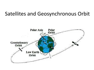
Satellites Types 2 Types of Satellites: Low Earth Orbiting Search And Rescue (LEOSAR) - 6 on Orbit - Altitude: 500 miles (850 km) in Pole-Pole orbit - Performs Doppler locating function (primary means of locating not GPS) - Stores & Forwards alerts continuously for 48 hours (provides worldwide coverage and total system redundancy) Geostationary Orbiting Search And Rescue (GEOSAR)- 5 on Orbit - Altitude: 23,000 miles (36,000 km) in fixed orbit - Performs instantaneous alerting function. No locating capability unless beacon is equipped with GPS - Coverage from 70N 70S
LEOSAR Satellites Polar orbiting take approximately 101-105 minutes to orbit Orbit is approximately 850 km in altitude Earth rotates 25 degrees longitude per orbit Provides global coverage Presently, 5 operational (S7, S8, S10, S11, S12 and S13)
LEOSAR Satellites Polar orbiting and 101-105 min. per orbit Orbit is 850 km in altitude Earth rotates 25 degrees longitude per orbit Provides global coverage twice per day Presently, 6 operational (S7, S8, S10, S11, S12 and S13) 3 distinct orbit planes w 2 satellites in each plane
LEOSAR Instantaneous Coverage Real Time Tracking available at : http://www.sarsat.noaa.gov/sat-tracking.html
LEO Local and Global Coverage 406 MHz beacon detections can be stored on board the satellite and re-broadcast later Local Coverage Global Coverage Local Coverage Detection of a 406 MHz beacon may use mutual visibility between beacon, satellite and ground station (LUT)
Determining Beacon Locations From LEO Doppler Data GEOMETRY FOR OVERHEAD PASS T2 850 km 3400 km T1 T3 Distress Beacon DOPPLER SHIFT CAUSES FREQUENCY TO APPEAR HIGHER THAN ACTUAL Frequency High TIME OF CLOSET APPROACH (AND ACTUAL FREQUENCY) Actual DOPPLER SHIFT CAUSES FREQUENCY TO APPEAR LOWER THAN ACTUAL Low Time T3 T1 T2
Resolving Ambiguity 2B 2A 1A 1B 2 1 Two Pass Solution for a Beacon Located in Brazil LEGEND: ground tracks of successive spacecraft orbits 1A, 1B Real and Image solutions from pass 1 2A, 2B Real and Image solutions from pass 2 1 2
GEOSAR Satellites At a fixed point 36,000 km above the Earth s surface Continually monitors a large area of Earth s surface Covers up to +/- 75o latitude Presently have 6 operational (Electro-1, GOES-12, GOES- 13, GOES-15, INSAT-3A, and MSG 3) No Doppler shift capability
GEOSAR Satellites Indian National Satellite (INSAT) Meteosat Second Generation (MSG)
GEOSAR Satellites (Cont.) Geosynchronous Operational and Environmental Satellite (GOES) Electro L1 Meteorological Satellite
GEOSAR Coverage Worldwide real-time coverage Real Time Tracking available at : http://www.sarsat.noaa.gov/sat-tracking.html
Advantages ofLEOSAR System over the GEOSAR System Locates beacons using Doppler shift processing. GEOSAR system does not have Doppler capability. Provides global coverage for 406 MHz. GEOSAR system does not cover the polar areas. Provides improved detection probability for obstructed beacons that can t be seen by GEOSAR such as mountain ranges or canyons (see next slide) Receives higher power levels from beacons, which increases the probability for beacon detection.
Beacon Detection with Obstruction Path of LEO satellite. GEO Satellite Beacon RF Coverage
Advantages ofGEOSAR System over the LEOSAR System Near instantaneous detection. Near instantaneous location determination for beacons with GPS capacity Continuous monitoring of ~1/3 of Earth s \ surface
Advantages ofa combined LEOSAR/GEOSAR System Real Time Tracking available at : http://www.sarsat.noaa.gov/sat-tracking.html
Use of GPS in Location Protocol Beacons 4 GPS Satellites C/S Satellites 15% of beacons are Location Protocol LUT C/S = communication / search
Use of GPS in Location Protocol Beacons GPS Satellites 24-satellite constellation 4 satellites in view at all times Minimum of 3 satellites needed to compute locations. Additional satellites improve accuracy. Transmit time and orbital data 4 GPS Satellites C/S Satellites 406 MHz Beacon with GPS Receiver Uses satellite-beacon time difference to calculate distance from each GPS satellite Uses GPS satellite orbital data and distance from beacon to calculate beacon location. Encodes location in 406 MHz message. LUT
LEOLUTS and GEOLUTS (Cospas-Sarsat Ground Stations) LEOSAR Local User Terminals (LEOLUT) - Track COSPAS and SARSAT satellites (POES & METOP) - Recover beacon signals - Perform error checking - Perform Doppler processing - Send alert to Mission Control Center GEOSAR Local User Terminals (GEOLUT) - Track GOES, MSG, & INSAT satellites - Recover beacon signals - Perform error checking - Send alert to Mission Control Center 35
Ground Segment 57 LEOLUTs in 46 Locations
Ground Segment 23 GEOLUTs in 20 Locations
Mission Control Centres (MCCs) - Receive alerts from national LUTs and foreign MCCs. - Validate, match and merge alerts to improve location accuracy and determine the correct destination. - Query 406 MHz Registration Database and transmit registration info with distress alert. - Transmit alerts (SIT msgs) to Rescue Coordination Centers (RCCs) and SAR Points of Contact (SPOC) and filters redundant data. - Most MCC functions are handled automatically no manual intervention = efficiency! SIT = standard identification type USMCC 38 Suitland, Maryland
Importance of Registration Identification Digital data transmitted by beacon provides nationality and type of beacon Tail number or other identifying information can be encoded into the beacon Registration Database provides additional information such as owner/operator, and can include specifics on aircraft or vessel Use of Registration Database to contact owner or emergency POC; this allows rescue forces to get more detailed information such as nature of emergency, severity of injuries, number of people involved, etc. and can help determine if alert is actual distress In most cases, false alerts are resolved prior to launch of resources, saving taxpayer $$ POC = point of contact
406 MHz Beacon Users in the U.S. www.beaconregistration.noaa.gov 40
U.S. SAR Partners Search and Rescue Partners: DOI DOC Research and Development SAR Facilities DOD NASA FCC Logo: Return to FCC Home Page DHS FCC
Rescue Coordination Centers (RCC) - Receive SARSAT Distress Alerts from MCCs - Coordinate the Rescue Response Click to download
US RCCs & their Search and Rescue Areas of Responsibility AKRCC Elmendorf AFB RCC CLEVELAND RCC JUNEAU RCC RCC BOSTON SEATTLE AFRCC Tyndall AFB RCC NORFOLK RCC RCC RCC GUAM ALAMEDA HONOLULU RCC SAN JUAN RCC MIAMI RCC NEW ORLEANS 44
National Rescue Data Number rescued world-wide since 1982: over 32,000 Number rescued in United States since 1982: 7,000 CY 2012 263 Rescues in 111 Events 182 people rescued in 54 incidents Rescues at sea: Aviation rescues: 22 people rescued Terrestrial rescues: 59 people rescued in 13 incidents in 44 incidents
Future Enhancements Current Limitations GEOSAR: Coverage limited to 70N to 70S Fixed geometry to emergency beacon No Doppler or independent location capability LEOSAR: Waiting time Payload configuration fixed system Performance variations between SAR payloads System reliability
Future Enhancements Repeaters will be flown on Medium Earth Orbit (MEO) satellites Will utilize 3 Global Navigation Satellite System (GNSS) constellations GPS (USA) GLONASS (Russia) Galileo (Europe) Current plan is to have 24 US MEOSAR instruments 72 MEOSAR instruments total
Future Enhancements Future Capability Medium Earth Orbit SAR System (MEOSAR) Improved Position Accuracy Decrease in waiting time Robust Space Segment which operates even if some of the satellites fail
Any Questions? www.sarsat.noaa.gov


")


")


")