Short-Term Prediction Research and Transition Center Mission
The Short-Term Prediction Research and Transition (SPoRT) Center aims to enhance short-term weather forecasts by transitioning unique NASA and NOAA observations and research to the operational weather community. SPoRT collaborates closely with WFOs and National Centers, demonstrating the effectiveness of experimental products for improved weather applications. Through partnerships and co-funding by NOAA, SPoRT has successfully integrated experimental data into operational settings, benefiting forecasters and advancing the use of next-generation weather satellites.

Download Presentation

Please find below an Image/Link to download the presentation.
The content on the website is provided AS IS for your information and personal use only. It may not be sold, licensed, or shared on other websites without obtaining consent from the author. If you encounter any issues during the download, it is possible that the publisher has removed the file from their server.
You are allowed to download the files provided on this website for personal or commercial use, subject to the condition that they are used lawfully. All files are the property of their respective owners.
The content on the website is provided AS IS for your information and personal use only. It may not be sold, licensed, or shared on other websites without obtaining consent from the author.
E N D
Presentation Transcript
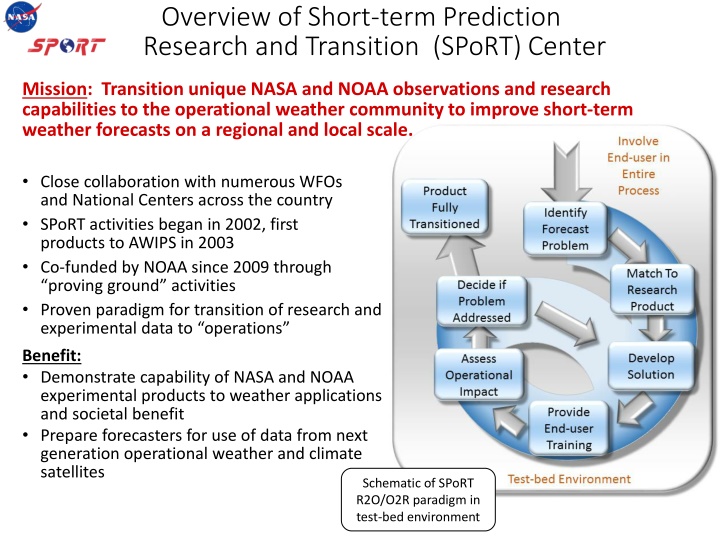
Overview of Short-term Prediction Research and Transition (SPoRT) Center Mission: Transition unique NASA and NOAA observations and research capabilities to the operational weather community to improve short-term weather forecasts on a regional and local scale. Close collaboration with numerous WFOs and National Centers across the country SPoRT activities began in 2002, first products to AWIPS in 2003 Co-funded by NOAA since 2009 through proving ground activities Proven paradigm for transition of research and experimental data to operations Benefit: Demonstrate capability of NASA and NOAA experimental products to weather applications and societal benefit Prepare forecasters for use of data from next generation operational weather and climate satellites Schematic of SPoRT R2O/O2R paradigm in test-bed environment
Transition of L1 GMI Data to Forecasters Real-time processing and image by: Frank LaFontaine (Raytheon) Dr. Robert Atkinson (USRA) Kevin McGrath (Jacobs) Cyan: Non-convective clouds Red: Colder cloud tops associated with intense convection and precipitation Used by forecasters to get a fix on the center of a tropical system Hurricane Iselle as observed by the GPM Microwave Imager; screen capture from N-AWIPS Decision Support System used at NOAA NHC and WPC SPoRT has transitioned unique, real-time GPM products to NOAA s National Hurricane Center (NHC) and Weather Prediction Center (WPC) Image above shows combination of 3 channels (89 GHz) to from an RGB composite used by forecasters to locate the center and strongest convection of tropical systems
Transition of L2 Rain Rate Data to Forecasters Default color curve MRMS color curve in AWIPS II Identifies strongest precipitation clearly Identifies very low rates and overall structure Images by: Frank LaFontaine (Jacobs) Geoffrey Stano (ENSCO, Inc.) SPoRT obtains real-time L2 rain rate data from the GPM Processing System, formats for AWIPS II, and disseminates to forecasters via LDM Can supplement radar information in data-void regions over water and parts of western U.S. Evaluation planned for July/August with NWS WFOs to investigate operational impact of L2 observations in detecting and aiding in forecast of monsoon events
Transition of L3 IMERG Data to Forecasters Image by: Matt Smith (UAH) Hurricane Blanca 2100 UTC 4 June 2015 SPoRT obtains real-time IMERG data from the GPM Processing System, formats for AWIPS II, and disseminates to forecasters via LDM Due to latency, most useful for hydrologic applications to pinpoint areas of heaviest rainfall outside of radar coverage Evaluation planned for this fall with River Forecast Center forecasters in Southern Alaska
Integration of IMERG Product into Real- Time Land Surface Model Images by: Jonathan Case (ENSCO, Inc.) SPoRT has completed work to integrate the GPM L3 IMERG product into a real-time, high- resolution version of the NASA Land Information System (LIS) used by SERVIR partners in East Africa for soil moisture diagnostics and local NWP model initialization IMERG (right) replaces legacy CMORPH (left) as the precipitation forcing dataset for OCONUS SPoRT-LIS IMERG will also be used by forecasters to validate regional model forecasts of precipitation
Assimilation of GPM Products into Regional NWP Control Model Simulation GMI L2 rain rates Oversimulation of stratiform rain over IL/IN Images by: Xuanli Li (UAH) SPoRT-funded project to integrate L2 GPM observations into the Gridpoint Statistical Interpolation (GSI) data assimilation system for regional NWP applications Generate packages in community GSI to assimilate GPM data (L2 GMI rainfall and DPR reflectivity) Will work with Developmental Testbed Center (DTC) to transition new assimilation modules into the community GSI for use by the weather community and potential integration into operational systems
Summary As part of SPoRT s Early Adopter Efforts, GPM observations have been transitioned to operational forecasters to address specific forecast challenges Forecast challenges addressed: Pinpoint the center of tropical cyclones (NHC, WPC/OPC) Supplement radar data for nowcasting precipitation in data void regions (WFOs) More accurate accumulated precipitation observations in radar void regions for hydrologic applications (RFCs) Forcing for international land surface models Assimilation into regional forecast models to improve precipitation NWP forecasts As assessments unfold, SPoRT will share feedback on the operational utility of GPM products with the Science Team


