Still Creek Oregon Nordic Club Day Tour - Experience a Unique Ski Adventure
Join the Still Creek Oregon Nordic Club Day Tour this Saturday for an adventurous point-to-point skiing excursion. Explore the beautiful landscape, drop over 2,000 feet along Still Creek, and enjoy the thrill of this advanced-level tour. Carpooling, estimated timings, and difficulty ratings provided. Prepare for a day full of excitement and uncertainty in the serene wilderness.

Download Presentation

Please find below an Image/Link to download the presentation.
The content on the website is provided AS IS for your information and personal use only. It may not be sold, licensed, or shared on other websites without obtaining consent from the author. If you encounter any issues during the download, it is possible that the publisher has removed the file from their server.
You are allowed to download the files provided on this website for personal or commercial use, subject to the condition that they are used lawfully. All files are the property of their respective owners.
The content on the website is provided AS IS for your information and personal use only. It may not be sold, licensed, or shared on other websites without obtaining consent from the author.
E N D
Presentation Transcript
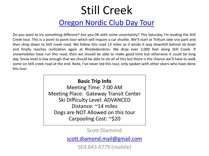
Still Creek Oregon Nordic Club Day Tour Do you want to try something different? Are you OK with some uncertainty? This Saturday I m leading the Still Creek tour. This is a point to point tour which will require a car shuttle. We ll start at Trillium lake sno park and then drop down to Still creek road. We follow this road 13 miles as it winds it way downhill behind ski bowl and finally reaches civilization again at Rhododendron. We drop over 2,000 feet along Still Creek. If snowmobiles have run this road, then we should be able to make good time but otherwise it could be long day. Snow level is low enough that we should be able to ski all of this but there is the chance we ll have to walk some on Still creek road at the end. Note, I ve never led this tour, only spoken with other skiers who have done this tour. Basic Trip Info Meeting Time: 7:00 AM Meeting Place: Gateway Transit Center Ski Difficulty Level: ADVANCED Distance: ~14 miles Dogs are NOT Allowed on this tour Carpooling Cost: ~$20 Scott Diamond scott.diamond.mail@gmail.com 503.643.6779 (mobile)
Cancellation Cancellations are rare but they do occasionally happen Please check your e-mail before driving out to carpool spot. I ll e-mail only if there is a cancel or change in plans, otherwise the trip is on.
Tour Starting Point We carpool from Gateway But we drop the vehicles off at Still Creek Road Still Creek Road is at ~ Mile Post 43.6 on HWY 26 After Zig Zag and just before the town of Rhododendron (where Dairy Queen is) If you see big overhead chain up sign, you ve gone too far Parking We ll drive in as far as safe. At a minimum we ll drive in 0.3 miles but we may drive in an additional 0.8 miles to some pullouts on the side of the road We then drive to Trillium Lake Sno-Park
Estimated Timing It is always hard to predict how long a tour will take. Obviously it depends on skiing ability and snow conditions. Below is my estimate. 7:00 AM Departure from Gateway 8:15 AM Drop off cars at Still Creak 9:00 Trillium 9:15 AM Start Skiing 3:30 PM? Still Creek (your estimate is as good as mine) 3:45 Leave Still Creek to Trillium 4:15 Leave Trillium back to Gateway 6:00 PM back at Gateway Note that if you need to rent skis you ll need to rent them prior to the trip. It takes quite a while to rent and it doesn t work to split the group and try and regroup when renting on the way
Difficulty Rating Scale 5 (advanced) 5 5 4 4 4 3 3 3 2 2 2 1 1 1 0 (novice) 0 0 Isolation/Risk Skiing Fitness Technical Skiing Ability
Appropriate Skis for this Tour The following types of skis, listed in green, should be suitable for this tour. Please see ONC Ski Gear webpage for more information on equipment. Skate Ski Competitive Cross Country/Track Ski Light touring ski <- probably best for this tour Backcountry Ski (typically metal edged) Telemark Ski AT (Advanced Touring) or Randonee Ski The above recommendations depend on the skill of the skier. Please contact me if you have questions.
Route (see CalTopo link to download your own, high res, map)
GPS Map Link (you are not required to bring a GPS but I m making this available) GPS Track on GPSies The link above allows you to easily download a GPX file or you can use their iPhone app GPS Track on CalTopo The link above allows you to easily print a map of our route Sample map from CalTopo
ONC Carpooling Policy If we don t have drivers, we don t have a trip. If you have a snow compatible car then please offer to drive. If we don t have enough drivers then we ll do a lottery to see who goes. For passengers, the ONC policy is each passenger contributes 15 cents per mile. For three or more passengers, the maximum total contribution by all passengers is limited to 45 cents per mile. A typical round trip distance to Mt Hood and back is 120 miles to 160 miles = $18-$24/person
ONC Ski Rating Novice level These tours are for the inexperienced skiers. While this is not a lesson, the leader will help new skiers as much as possible. Tour length is 3-5 miles over nearly flat terrain. Beginning/Easy level 4 to 6 Miles over gentle terrain at a pace comfortable for all participants Intermediate level 6 to 12 miles. Terrain flat to long hills that are no steeper than found on a road (maximum 10 degrees). Moderate pace. Trail turning skills required, if there are hills. Advanced level > 12 miles. Terrain flat to steep hills (> 10 degrees). Moderate to fast pace. Strong turning skills required on the tours with steeper slopes.
What to Bring/Gear (click links below for more info) Ski Rental Options What to Wear Tour Essentials Chocolate for trip leaders! Note that if you need to rent skis you ll need to rent them prior to the trip. It takes quite a while to rent and it doesn t work to split the group and try and regroup when renting on the way
Electronic Map/GPS Forget paper maps! I ve given up carrying paper maps and instead use my smartphone to see the track and where I am. This works really well. Numerous smartphone GPS apps are available, my own favorite is Gaia ($20). For the ski-nerd , there is a ski trail GPX database on the club website. See me at one of the club meetings if you need some help using this. I ll assist for the cost of a pint! Sample screen shot for Gaia iPhone Software
Maps/Guides Maps and Guidebooks are great for studying trip options at home. Note - There are always new trails being developed and the maps I have included in this packet may not be the most recent. If you want to buy your own maps for this trip then the best one I ve found for Mt. Hood is the 2015 Mt. Hood Winter Trails (BuyBetterMaps, Amazon or your local REI) The best overall reference books is still Klindt Vielbig s. This is out of print but you can still find used copies on Amazon
Weather Reports Obviously the tour gets cancelled if we don t have enough snow. Additionally if it looks like it is just going to rain on us all day then we ll cancel. I like to use the following site to check the weather. National Weather Service Zone Forecast. Good general description and snow level info. Mount Hood WebCams. Amar Andalkar does a great job at pulling together all the WebCams. For day tours I like to look to see how much snow there is in Government Camp Northwest Avalanche Center Not applicable to the vast majority of ONC tours (since we rarely ski on or across slopes steep enough to avalanche)