Supervised Classification in Satellite Image Analysis
"Explore the concept of supervised classification in satellite image analysis, where analysts use training areas to categorize surface cover types, train computers, and generate thematic maps for GIS applications. Learn about advantages and popular classification methods in this informative guide."

Uploaded on | 2 Views
Download Presentation

Please find below an Image/Link to download the presentation.
The content on the website is provided AS IS for your information and personal use only. It may not be sold, licensed, or shared on other websites without obtaining consent from the author. If you encounter any issues during the download, it is possible that the publisher has removed the file from their server.
You are allowed to download the files provided on this website for personal or commercial use, subject to the condition that they are used lawfully. All files are the property of their respective owners.
The content on the website is provided AS IS for your information and personal use only. It may not be sold, licensed, or shared on other websites without obtaining consent from the author.
E N D
Presentation Transcript
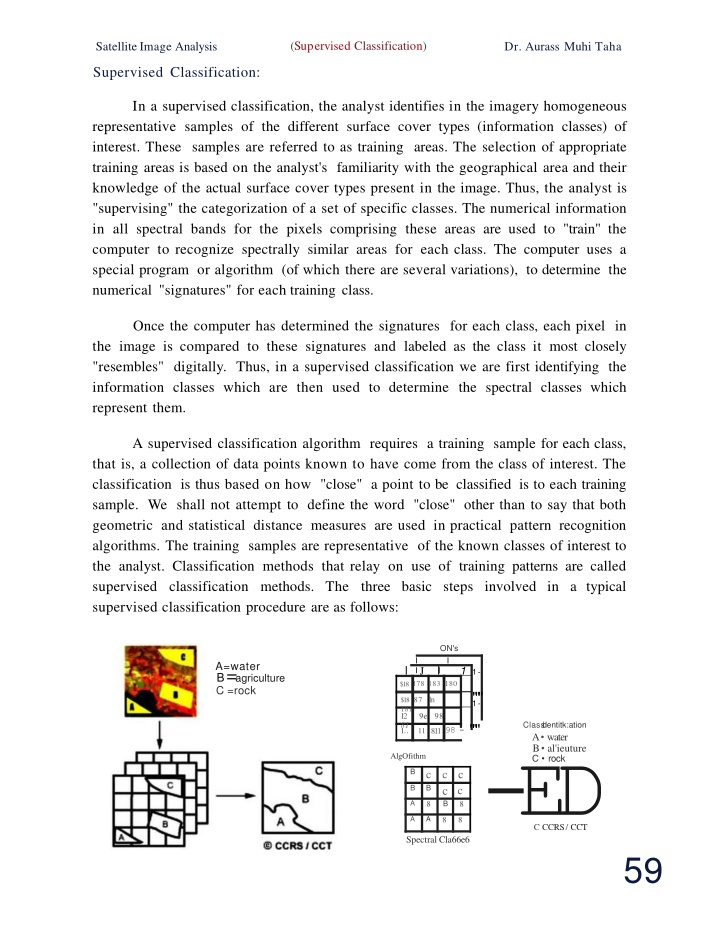
(Supervised Classification) SatelliteImage Analysis Dr. Aurass Muhi Taha Supervised Classification: In a supervised classification, the analyst identifies in the imagery homogeneous representative samples of the different surface cover types (information classes) of interest. These samples are referred to as training areas. The selection of appropriate training areas is based on the analyst's familiarity with the geographical area and their knowledge of the actual surface cover types present in the image. Thus, the analyst is "supervising" the categorization of a set of specific classes. The numerical information in all spectral bands for the pixels comprising these areas are used to "train" the computer to recognize spectrally similar areas for each class. The computer uses a special program or algorithm (of which there are several variations), to determine the numerical "signatures" for each training class. Once the computer has determined the signatures for each class, each pixel in the image is compared to these signatures and labeled as the class it most closely "resembles" digitally. Thus, in a supervised classification we are first identifying the information classes which are then used to determine the spectral classes which represent them. A supervised classification algorithm requires a training sample for each class, that is, a collection of data points known to have come from the class of interest. The classification is thus based on how "close" a point to be classified is to each training sample. We shall not attempt to define the word "close" other than to say that both geometric and statistical distance measures are used in practical pattern recognition algorithms. The training samples are representative of the known classes of interest to the analyst. Classification methods that relay on use of training patterns are called supervised classification methods. The three basic steps involved in a typical supervised classification procedure are as follows: ON's I I I I J l 1 1- $18 178 183 180 A=water B=agriculture C =rock l """ 1- $18 87 1n 181 12 9e 98 81 11 811 98 -""" Class l dentitk:ation A water B al'ieuture C rock 1.. -E C CCD AlgOfithm B c B c c c B c B A 8 8 A A 8 8 RS/ CCT Spectral Cla66e6 59
(Supervised Classification) Satellite Image Analysis Dr. Aurass Muhi Taha 1) Training stage: The analyst identifies representative training areas and develops numerical descriptions of the spectral signatures of each land cover type of interest in the scene. 2)The classification stage: Each pixel in the image data set is categorized into the land cover class it most closely resembles. If the pixel is insufficiently similar to any training data set it is usually labeled 'Unknown'. 3)The output stage: The results may be used in a number of different ways. Three typical forms of output products are thematic maps, tables and digital data files which become input data for GIS. The output of image classification becomes input for GIS for spatial analysis ofthe terrain. There are a number of powerful supervised classifiers based on the statistics, which are commonly , used for various applications. A few of them are a minimum distance to means method, average distance method, parallelepiped method , maximum likelihood method, modified maximum likelihood method, 8aysian's method, decision tree classification, and discriminant functions. The principles and working algorithms of all these supervised classifiers are available in almost all standard books on remote sensing and so details are not provided here. Advantages of Supervised Classification: The advantages of supervised classification, relative to unsupervised classification, can be enumerated as follows: 1) The analyst has control of a selected menu of informational categories tailored to a specific purpose and geographic region. This quality may be vitally important if it becomes necessary to generate a classification for the specific purpose of comparison with another classification of the same area at a different date or if the classification must be compatible with those of neighboring regions. Under such circumstances, the unpredictable (i.e., with respect to number, identity, size, and pattern) qualities of categories generated by unsupervised classification may be inconvenient or unsuitable. 3) Supervised classification is tied to specific areas of known identity, determined through the process of selecting training areas. 3) The analyst using supervised classification is not faced with the problem of matching spectral categories on the final map with the informational categories of interest (this task has, in effect, been addressed during the process of selecting training data). 60
(Supervised Classification) Satellite Image Analysis Muhi Taha Dr. Aurass 4) The operator may be able to detect serious errors in classification by examining training data to determine whether they have been correctly classified by the procedure inaccurate classification of training data indicates serious problems in the classification or selection of training data, although correct classification of training data does not always indicate correct classification of other data. Disadvantages and Limitations of Supervised Classification: The disadvantages of supervised classification are numerous: 1) The analyst, in effect, imposes a classification structure on the data (recall that unsupervised classification searches for "natural" classes). These operator-defined classes may not match the natural classes that exist within the data and therefore may not be distinct or well defined in multidimensional data space. 2)Training data are often defined primarily with reference to informational categories and only secondarily with reference to spectral properties. A training area that is "100% forest" may be accurate with respect to the "forest" designation but may still be very diverse with respect to density, age, shadowing, and the like, and therefore form a poor training area. 3)Training data selected by the analyst may not be representative of conditions encountered throughout the image. This may be true despite the best efforts of the analyst, especially ifthe area to be classified is large, complex, or inaccessible. 4)Conscientious selection of training data can be a time-consuming, expensive , and tedious undertaking, even if ample resources are at hand. The analyst may experience problems in matching prospective training areas as defined on maps and aerial photographs to the image to be classified. 5)Supervised classification may not be able to recognize and represent special or unique categories not represented in the training data, possibly because they are not known to the analyst or because they occupy very small areas on the image. Training Data: Training fields are areas of known identity delineated on the digital 1mage, usually by specifying the corner points of a square or rectangular area using line and column numbers within the coordinate system of the digital image. The analyst must, of course, know the correct class for each area. 61
(Supervised Classification) SatelliteImage Analysis Dr. Aurass Muhi Taha Usually the analyst begins by assembling and studying maps and aerial photographs of the area to be classified and by investigating selected sites in the field. (Here we assume that the analyst has some field experience with the specific area to be studied, is familiar with the particular problem the study is to address, and has conducted the necessary field observations prior to initiating the actual selection of training data.) Specific training areas are identified for each informational category, following the guidelines outlined below. The objective is to identify a set of pixels that accurately represent spectral variation present within each informational region as presented in figure below, where Training fields and training data. Training fields, each composed of many pixels, sample the spectral characteristics of informational categories. Here the shaded figures represent the training fields, each positioned carefully to estimate the spectral properties of each class, as depicted by the histograms. This information provides the basis for classification of the remaining pixels outside the training fields. DARK BRIGHT BRIGHTNESS Characteristics of T1 aining A1 eas: 1) Numbers of Pixels: An important concern is the overall number of pixels selected for each category; as a general guideline, the operator should ensure that several individual training areas for each category provide a total of at least 100pixels for each category. 2) Size: sizes of training areas are important. Each must be large enough to provide accurate estimates of the properties of each informational class. Therefore, they must as a group include enough pixels spectral characteristics of each class (hence, the minimum figure of 100 suggested above). Individual training fields should not, on the other hand, be too big, as large areas tend6 2 to form reliable estimates of the
(Supervised Classification) Dr. Aurass Satellite Image Analysis Muhi Taha to include undesirable variation. (Because the total number of pixels in the training data for each class can be formed from many separate training fields, each individual area can be much smaller than the total number of pixels required for each class.) The recommendation that individual training areas be at least 4 ha (10 acres) in size at the absolute minimum and preferably include about 16 ha (40 acres). Small training fields are difficult to locate accurately on the image. To accumulate an adequate total number of training pixels, the analyst must devote more time to definition and analysis of the additional training fields. Conversely, use of large training fields increases the opportunity for inclusion of spectral inhomogeneities. 3) Shape: shapes of training areas are not important, provided that shape does not prohibit accurate delineation and positioning of correct outlines of regions on digital images. Usually it is easiest to define square or rectangular areas such shapes minimize the number of vertices that must be specified, usually the most bothersome task for the analyst. 4)Location: Location is important , as each informational category should be represented by several training areas positioned throughout the image. Training areas must be positioned in locations that favor accurate and convenient transfer of their outlines from maps and aerial photographs to the digital image. As the training data are intended to represent variation within the image, they must not be clustered in favored regions of the image that may not typify conditions encountered throughout the image as a whole. It is desirable for the analyst to use direct field observations in the selection of training data, but the requirement for an even distribution of training fields often conflicts with practical constraints, as it may not be practical to visit remote or inaccessible sites that may seem to form good areas for training data. Often aerial observation or use of good maps and aerial photographs can provide the basis for accurate delineation of training fields that cannot be inspected in the field. Although such practices are often sound, it is important to avoid development of a cavalier approach to selection of training data that depends completely on indirect evidence in situations in which direct observation is feasible. the optimum number of training areas depends on the number of 5)Number: categories to be mapped , their diversity , and the resources that can be devoted to delineating training areas. Ideally, each informational category or each spectral subclass should be represented by a number (5-10 at a minimum) of training areas to ensure that the spectral properties of each category are represented. Because informational classes are often spectrally diverse, it may be necessary to use several sets of training data for each informational category, due to the presence of spectral subclasses. Selection of multiple training areas is also desirable because later in the 63
(Supervised Classification) Satellite Image Analysis Taha Dr. Aurass Muhi classification process it may be necessary to discard some training areas if they are discovered to be unsuitable. Experience indicates that it is usually better to define many small training areas than to use only a few large areas. 6) Placement: placement of training areas may be important. Training areas should be placed within the image in a manner that permits convenient and accurate location with respect to distinctive features, such as water bodies, or boundaries between distinctive features on the image. They should be distributed throughout the image so that they provide a basis for representation of the diversity present within the scene. Boundaries of training fields should be placed well away from the edges of contrasting parcels so that they do not encompass edge pixels. 7) Uniformity: perhaps the most important property of a good training area is its uniformity, or homogeneity: BRIGHTNESS - - - + BRIGHTNESS --... "UNIFORM" "HETEROGENEOUS" Data within each training area should exhibit a unimodal frequency distribution for each spectral band to be used. Prospective training areas that exhibit bimodal histograms should be discarded if their boundaries cannot be adjusted to yield more uniformity. Training data provide values that estimate the means, variances, and covariances of spectral data measured in several spectral channels. For each class to be mapped, these estimates approximate the mean values for each band, the variability of each band, and the interrelationships between bands. As an ideal, these values should represent the conditions present within each class within the scene and thereby form the basis for classification of the vast majority of pixels within each scene that do not belong to training areas. In practice, of course, scenes vary greatly in complexity, and individual analysts differ in their knowledge of a region and in their ability to define training areas that accurately represent the spectral properties of informational classes. Moreover, some informational classes are not spectrally uniform and cannot be conveniently represented by a single set of training data. 64
(Supervised Classification) Dr. Aurass Muhi Taha Satellite Image Analysis Significance of Training Data: Selection of training data may be as important as or even more important than choice of classification algorithm in determining agricultural areas in the central United States. They concluded that differences in the selection of training data were more important influences on accuracy than were differences among some five different classification procedures. classification accuracies of The results oftheir studies show little difference in the classification accuracies achieved by the five classification algorithms that were considered, if the same training statistics were used. However, in one part ofthe study, a classification algorithm given two alternative training methods for the same data produced significantly different results. This finding suggests that the choice of training method , at least in some instances, is as important as the choice of classifier. The conclusion that the most important aspect oftraining fields is that all cover types in the scene must be adequately represented by a sufficient number of samples in each spectral subclass. The character of the training data as it influences accuracy of the classification. His examples showed that adjacent pixels within training fields tended to have similar values as a result, the samples that compose each training field may not be independent samples of the properties within a given category. Training samples collected in contiguous blocks may tend to underestimate the variability within each class and to overestimate the distinctness of categories. Also the degree of similarity varies between land-cover categories, from band to band, and from date to date. Iftraining samples are selected randomly within classes, rather than as blocks of contiguous pixels, effects of high similarity are minimized, and classification suggest that it is probably better to use a large number of small training fields rather than a few large areas. accuracies improve. The results Idealized Sequence for Selecting Training Data: Specific circumstances for conducting supervised classification vary greatly, so it is not possible to discuss in detail the procedures to follow in selecting training data, which will be determined in part by the equipment and software available at a given facility. However, it is possible to outline an idealized sequence as a suggestion ofthe key steps in the selection and evaluation of training data: 1.Assemble information, including maps and aerial photographs of the region to be mapped. 65
(Supervised Classification) Dr. Aurass Satellite Image Analysis Muhi Taha 2.Conduct field studies, to acquire firsthand information regarding the area to be studied. The amount of effort devoted to field studies varies depending on the analyst 's familiarity with the region to be studied. If the analyst is intimately familiar with the region and has access to up-to-date maps and photographs , additional field observations may not be necessary. 3.Carefully plan collection of field observations and choose a route designed to observe all parts of the study region. Maps and images should be taken into the field in a form that permits the analyst to annotate them, possibly using overlays or photocopies of maps and images. It is important to observe all classes ofterrain encountered within the study area, as well as all regions. The analyst should keep good notes , keyed to annotations on the image, and cross-referenced to photographs. If observations cannot be timed to coincide with image acquisition, they should match the season in which the remotely sensed images were acquired. 4.Conduct a preliminary examination of the digital scene. Determine landmarks that may be useful in positioning training fields. Assess image quality. Examine frequency histograms of the data. 5.Identify prospective training areas, using guidelines proposed by Joyce (1978) and outlined here. Sizes of prospective areas must be assessed in the light of scale differences between maps or photographs and the digital image. Locations of training areas must be defined with respect to features easily recognizable on the image and on the maps and photographs used as collateral information. 6.Display the digital image, then locate and delineate training areas on the digital image. Be sure to place training area boundaries well inside parcel boundaries to avoid including mixed pixels within training areas. At the completion of this step, all training areas should be identified with respect to row and column coordinates within the image. 7.For each spectral class, evaluate the training data, using the tools available in the imaging-possessing system of choice. Assess uniformity of the frequency histogram , class separability as revealed by the divergence matrix,the degree to which the training data occupy the available spectral data space,and their visual appearance onthe image. 8.Edit training fields to correct problems identified in step 7. Edit boundaries of training fields as needed. If necessary, discard those areas that are not suitable. Return to Step 1to define new areas to replace those that have been eliminated. 9. Incorporate training data information into a form suitable for use in the classification procedure and proceed with the classification process. 66
")
")
")
")
")
")
")
")