Thames Estuary 2100 Plan: Protecting Against Sea Level Rise
The Thames Estuary 2100 Plan aims to safeguard 1.42 million people and $321 billion worth of property from tidal flooding by enhancing flood defenses. The plan, led by the Environment Agency and JBA Consulting, involves restoring and adapting flood defenses along the Thames Estuary to combat the impacts of sea level rise. Partner organizations like City of London Corporation and Met Office are also involved in this strategic initiative.

Download Presentation

Please find below an Image/Link to download the presentation.
The content on the website is provided AS IS for your information and personal use only. It may not be sold, licensed, or shared on other websites without obtaining consent from the author. If you encounter any issues during the download, it is possible that the publisher has removed the file from their server.
You are allowed to download the files provided on this website for personal or commercial use, subject to the condition that they are used lawfully. All files are the property of their respective owners.
The content on the website is provided AS IS for your information and personal use only. It may not be sold, licensed, or shared on other websites without obtaining consent from the author.
E N D
Presentation Transcript
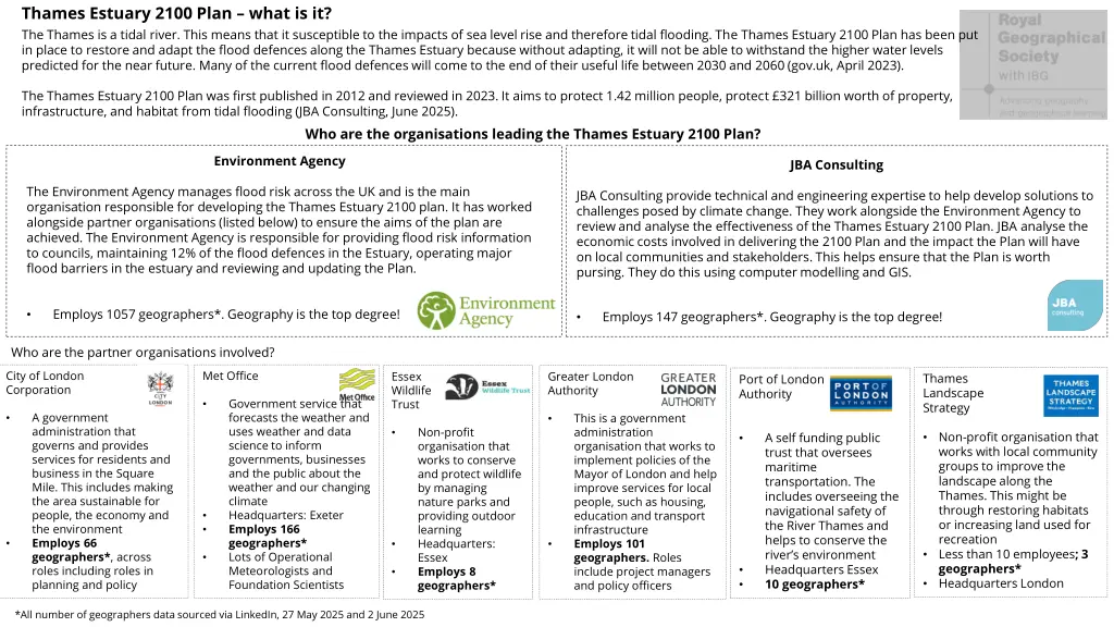
Thames Estuary 2100 Plan what is it? The Thames is a tidal river. This means that it susceptible to the impacts of sea level rise and therefore tidal flooding. The Thames Estuary 2100 Plan has been put in place to restore and adapt the flood defences along the Thames Estuary because without adapting, it will not be able to withstand the higher water levels predicted for the near future. Many of the current flood defences will come to the end of their useful life between 2030 and 2060 (gov.uk, April 2023). The Thames Estuary 2100 Plan was first published in 2012 and reviewed in 2023. It aims to protect 1.42 million people, protect 321 billion worth of property, infrastructure, and habitat from tidal flooding (JBA Consulting, June 2025). Who are the organisations leading the Thames Estuary 2100 Plan? Environment Agency JBA Consulting The Environment Agency manages flood risk across the UK and is the main organisation responsible for developing the Thames Estuary 2100 plan. It has worked alongside partner organisations (listed below) to ensure the aims of the plan are achieved. The Environment Agency is responsible for providing flood risk information to councils, maintaining 12% of the flood defences in the Estuary, operating major flood barriers in the estuary and reviewing and updating the Plan. JBA Consulting provide technical and engineering expertise to help develop solutions to challenges posed by climate change. They work alongside the Environment Agency to review and analyse the effectiveness of the Thames Estuary 2100 Plan. JBA analyse the economic costs involved in delivering the 2100 Plan and the impact the Plan will have on local communities and stakeholders. This helps ensure that the Plan is worth pursing. They do this using computer modelling and GIS. Employs 1057 geographers*. Geography is the top degree! Employs 147 geographers*. Geography is the top degree! Who are the partner organisations involved? City of London Corporation Met Office Essex Wildlife Trust Greater London Authority Thames Landscape Strategy Port of London Authority Government service that forecasts the weather and uses weather and data science to inform governments, businesses and the public about the weather and our changing climate Headquarters: Exeter Employs 166 geographers* Lots of Operational Meteorologists and Foundation Scientists A government administration that governs and provides services for residents and business in the Square Mile. This includes making the area sustainable for people, the economy and the environment Employs 66 geographers*, across roles including roles in planning and policy This is a government administration organisation that works to implement policies of the Mayor of London and help improve services for local people, such as housing, education and transport infrastructure Employs 101 geographers. Roles includeproject managers and policy officers Non-profit organisation that works to conserve and protect wildlife by managing nature parks and providing outdoor learning Headquarters: Essex Employs 8 geographers* Non-profit organisation that works with local community groups to improve the landscape along the Thames. This might be through restoring habitats or increasing land used for recreation Less than 10 employees; 3 geographers* Headquarters London A self funding public trust that oversees maritime transportation. The includes overseeing the navigational safety of the River Thames and helps to conserve the river s environment Headquarters Essex 10 geographers* *All number of geographers data sourced via LinkedIn, 27 May 2025 and 2 June 2025
What role do geographers play? Read through each job profile before completing the activities. Each role is based on a real job available to those with a geography degree. Senior programme officer at a governmental administration organisation This role sits in the climate change team where you are working to create climate change policy that will ensure London is a sustainable city for local communities and businesses. You will be an expert on climate change policy, including how to write policy and conduct policy research (a bit like a fieldwork investigation). This involves analysing data to monitor the social, cultural and economic impacts of climate change on London. Your work will inform decisions about how London is going to adapt to climate change and continue to grow its economy and thrive as a global city. You will help empower local businesses, councils and communities to take climate action by providing them with detailed policies to follow and implement to ensure that London s social, economic and cultural life thrives. Key Skills You have a through understanding of climate change and environmental policy Good research skills, including analysing and interpretating data Confident with using numerical data Good at problem solving Good time management Motivated, proactive and organised Salary 51, 029 per year to 63, 112 Climate change adaption officer at wildlife conservation charity This role involves advocating for nature-friendly flood engineering strategies that work with natural processes to help reduce the impacts of flooding (such as soft engineering strategies). You will work with organisations to develop adaptation plans, give advice to landowners about what they should do in response to increased flood risk, and prioritise the protection and restoration of natural habitats. You ll need to provide climate change expertise and lead and develop sustainable projects that protect nature and improve biodiversity. This involves organising events and workshops, and delivering presentations to various audiences, like local businesses or community groups to educate them on the importance of conserving habitats along the Thames. Key Skills Thorough knowledge of climate change and local habitats Able to communicate complicated information to different groups of people Innovative, resilient and self-motivated Committed to wildlife conservation Enthusiastic and inspiring communicator Organized and works well in a team Salary 31,000 - 35,000 per year Flood risk analyst at an engineering consultancy Key Skills This role involves working within the map team to develop and improve high-resolution flood maps. This involves working with geospatial and geo-located data to help build flood models and food defense databases. The maps that you create will show what will happen to a surrounding area when that area floods due to flooding. The maps will show changes to flood risk over time, which will help inform the work that needs to be done to reduce the impact of tidal flooding along the River Thames. You will work a lot with numerical data and GIS and your work will inform what strategies need to be put in place to ensure London is protected against increased risk of tidal flooding in the Thames Estuary. Strong GIS skills Able to handle data with confidence, have a strong numerical mindset and data analysis skills Positive attitude, enthusiastic about learning Ability to work independent and as part of a team Problem solver Able to communicate technical concepts to non- technical audiences Salary 42,460 to up to 86,000 per year in senior roles
There are 3 aims of the Thames Estuary 2100 Plan: Activity 1b Using the geographical professional job profiles, decide who is most appropriate person to advise on each aim to ensure that the aim is met A - Take an adaptive approach to manage tidal flooding and create climate resilient communities. Who is the most appropriate person help meet each aim? Aims Explain why This involves maintaining and improving flood defences, tracking changes in flooding over time using mapping tools and using spatial data to help create resilient communities that are prepared for change. B - Protect and enhance the value of the Thames, its tidal tributaries and floodplain. Deliver social, cultural and commercial benefits for communities and support resilient growth. A - Take an adaptive approach to manage tidal flooding and create climate resilient communities. This includes working with local communities to improve land use around the river in a way that benefits them. C - Tackle the climate and nature crises by putting sustainability at the heart of this Plan. Restore ecosystems, reduce carbon emissions, and deliver environmental and biodiversity net gain. This includes replacing habitats that have been lost due to sea level rise B - Protect and enhance the valueof the Thames, itstidal tributaries and floodplain. Deliver social, cultural and commercial benefits for communities and support resilientgrowth. Activity 1a Match the key word to its correct definition The interaction between biotic (living) and abiotic(non- living) components in an environment Adaptive Climate resilient Something being able to last into the future Tidal tributaries Land surrounding the river which is susceptible to flooding The ability of people and ecosystems to bounce back from climatic hazards C - Tackle the climate and nature crises by putting sustainability atthe heart ofthis Plan. Restore ecosystems, reduce carbon emissions, and deliver environmental and biodiversity netgain. Floodplain Adjusting something to respond to changing situations Sustainability Increasing the level of biodiversity (number of plant and animal species) living in an environment Ecosystems Smaller river flowing from a larger river into the sea Biodiversity net gain
Activity 2 Fieldwork exercise You are the Head of Climate Change at Greater London Authority and want to investigate how successful the Thames 2100 Plan has been for reducing the impact of flooding on local businesses. Create your own fieldwork investigation focusing on one of the Plan s aims (A, B or C). You must choose an aim, create a hypothesis and develop two methods of data collection (one primary and one secondary). Ensure to justify your methods of data collection and consider the limitations of each. My investigation will focus on Thames Estuary 2100 Plan aim A - Take an adaptive approach to manage tidal flooding and create climate resilient communities. for communities and support resilientgrowth. C - Tackle the climate and nature crises by putting sustainability atthe heart ofthis Plan. Restore ecosystems, reduce carbon emissions, and deliver environmental and biodiversity netgain. B - Protect and enhance the value of the Thames, its tidal tributaries and floodplain. Deliver social, cultural and commercial benefits Hypothesis Null hypothesis Primary data collection Primary data collection Primary data collection Primary data collection Secondary data collection Secondary data collection Secondary data collection Secondary data collection What? What? What? What? Why? Why? Why? Why? Type of data Type of data Type of data Type of data Qualitative Quantitative Qualitative Quantitative Type of sampling strategy Type of sampling strategy Type of sampling strategy Type of sampling strategy Stratified Random Stratified Random Systematic Systematic Location Location Limitations Limitations Location Location Limitations Limitations Number of samples Number of samples Number of samples Number of samples Justify Justify why are you going to collect this number of samples? Justify Justify why are you going to collect this number of samples?