Time-Based Simulation in Event Overlap Experiments
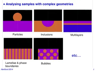
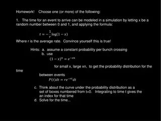
In the context of event-based simulations, addressing the issue of event overlaps is crucial for experimental accuracy. This presentation explores how sensor elements are affected by time delays between events, impacting data interpretation and detector responses. The challenges posed by continuous beams with short intervals between events, such as those encountered in the PANDA Computing Workshop, are highlighted. Strategies for handling event overlaps in simulations are discussed, emphasizing the importance of accurately representing real-world experimental conditions.

Uploaded on Feb 22, 2025 | 0 Views
Download Presentation

Please find below an Image/Link to download the presentation.
The content on the website is provided AS IS for your information and personal use only. It may not be sold, licensed, or shared on other websites without obtaining consent from the author.If you encounter any issues during the download, it is possible that the publisher has removed the file from their server.
You are allowed to download the files provided on this website for personal or commercial use, subject to the condition that they are used lawfully. All files are the property of their respective owners.
The content on the website is provided AS IS for your information and personal use only. It may not be sold, licensed, or shared on other websites without obtaining consent from the author.
E N D
Presentation Transcript
ORIENTATION PROGRRAME FOR SEMESTER 2023 (In accordance with NEP-2020) DEPARTMENT OF GEOGRAPHY PANCHAKOT MAHAVIDYALAYA SARBORI,PURULIA-723121
GEOGRAPHY MAJOR MINOR GEOGRAPHY 1 SEMESTER X
SYLLABUS FOR 1ST SEMESTER (MEJOR)COURSE Course Code Paper Code Course Title Course Type (L-P-Tu) Credit Introduction to Physical Geography & Elementary Practical's in Geography BGEOMJ01C 101 MJ-1 4-2-0 6 One from List of Minor Elective (ME) Minor-1 Subjects B***MEA11* 102 ME-1 *** 4 One from the List of Multidisciplinary Courses ***103 103 MDC-1 (GR-1) *** 3 ***104 104 One from List of SEC SEC-1 *** 3 ENVIRONMENTAL STUDIES BVACENV01T 105 VAC-1 2-2-0 4
Course Code: BGEOMJ01C Course Title: Introduction to Physical Geography Elementary Practical's in Geography Course Title: Introduction to Physical Geography Paper Type: Theoretical Course Credit: 4 Unit I: Our Earth and the Physical Environment 1.1 Interior of the Earth; Earth s tectonic and structural evolution through Geological Time Scale 1.2 Earth s atmosphere: Insolation; Pressure Belts; Planetary wind System; Greenhouse Effect and Global Warming. 1.3 Earth s hydrosphere: Global hydrological cycle; Ocean circulation major ocean currents. 1.4 Earth s Biosphere: Biogeographical realms of the world; Soils Zonal, Azonal and Intrazonal; Classification of forest (Champion). Unit II: Landforms and Landscape 2.1 Landforms: Types & Order. Concept & Theory of Isostasy (Airy & Pratt). Geomorphic Processes 2.2 Landforms due to Endogenic forces: Plate Tectonics and associated Landforms; Seismicity & Vulcanicity; Landform evolution in Uniclinal, Folded and Faulted structure 2.3 Landforms due to Exogenic Processes: Weathering & Mass Movement 2.4 Fluvial, Glacial, Aeolian, Coastal and Karst landscapes; Landscape evolution models: Davis, Penck and Hack
Course Title: Elementary Practical's in Geography Paper Type: Practical Course Credit: 2 Unit I: Scale, Minerals and Rocks 1.1 Concept and classification of Map Scales 1.2 Construction and use of scales: Simple linear, Comparative linear, Diagonal and Venire 1.3 Megascopic identification of Mineral samples: Bauxite, Calcite, Chalcopyrite, Feldspar, Galena, Gypsum, Hematite, Magnetite, Mica, Quartz, Talc, Tourmaline 1.4 Megascopic identification of Rock samples: Granite, Basalt, Dolerite, Laterite, Limestone, Shale, Sandstone, Conglomerate, Slate, Phyllis, Schist, Gneiss, Quartzite, Marble. Unit II: Interpretation of Geological Map 2.1 Basic ideas and conventional symbols. Choice of section line; series and unconformity; strike and dip; topography; rules of three-point problems for measuring dip. 2.2 Drawing of geological section - Horizontal, Anticlinal with unconformity, and Simple folded structure. 2.3 Interpretation of geological section based on a) topography; b) sequence of beds; c) attitude of beds d) structure of beds e) correlation between structure and topography; f) geological history Project File a) Construction of Scales: Simple linear, Comparative scale, Diagonal & Venire. b) Identification of Minerals and Rocks. c) Drawing and interpretation of geological section - Horizontal, Uniclinal with unconformity, & Simple,folded structure.
COURSE PATTERN, SCHEME AND EXAMINATION OF SYLLABUS FOR B.A. / B.Sc. PROGRAM As Per NEP (2023-2024 and onwards) MARKS DIVISION MARKS DIVISION PAPER CODE PAPER NO. TITEL TYPE DURATI ON OF EXAM INTERN AL EXAM SEMES TER EXAM TOTAL CREDIT INTRODUCTI ON TO PHYSICAL GEOGRAPHY THEORY DSCC1 1A 2HRS 10 40 50 4 ELEMENTAR Y IN GEOGRAPHY PRACTICAL 1B 2RS 5 20 25 2
SYLLABUS LINK https://syllabus.skbu.ac.in
ADD ON COURSE GEOGRAPHY DEPARTMENT Basics of Remote Sensing (RS) & Geographic Information Systems (GIS) with Hands-on Training (Computer Based) TRAVEL AND TOURISM (SPECIAL REFERENCE TO PURULIA AND SURROUNDINGS)
WHAT TO DONE 1)Anti Ragging Affidavit 2)DigiLocker 3)ABC ID 4) Mentor-Mentee Programme https://panchakotmv.ac.in/index/?pageid=7a4aj90c1fkb1f3a5a5a ba2f3faa5f8a1f6f
Basics of Remote Sensing (RS) & Geographic Information Systems (GIS) with Hands-on Training (Computer Based) Contents. Module I. Remote Sensing: definition and concept, types of RS, history of RS in India, technological changes in RS, applications of RS. Module II. Concept of GIS and spatial data model, process of GIS, planning and implementation of GIS, modern trends. Module III. Open source data for RS & GIS: Bhuvan, Hands on training to deal with spatial data using TNTmips software and Google Earth.
TRAVEL AND TOURISM (SPECIAL REFERENCE TO PURULIA AND SURROUNDINGS) MODULE 1-Concept of travel and tourism, Scope of travel and tourism, Basic knowledge regarding tourism. MODULE 2-Roll of geography in tourism, relation between economy and tourism. MODULE 3-Eco tourism. MODULE 4-Tourism of west Bengal (Mainly emphasis Purulia and surroundings) MODULE 5-Reason to choose career in travel and tourism, Job profile in travel and tourism sector.


COURSE")


 & Geographic Information")