Tropospheric Ozone Measurements at OHP: UV DIAL Lidar Data and Publications
Explore detailed information on tropospheric ozone measurements at OHP, including UV DIAL lidar data since 1990, surface O3 measurements, characteristics of UV DIAL at OHP, and recent publications on the topic since 2018.

Download Presentation

Please find below an Image/Link to download the presentation.
The content on the website is provided AS IS for your information and personal use only. It may not be sold, licensed, or shared on other websites without obtaining consent from the author. If you encounter any issues during the download, it is possible that the publisher has removed the file from their server.
You are allowed to download the files provided on this website for personal or commercial use, subject to the condition that they are used lawfully. All files are the property of their respective owners.
The content on the website is provided AS IS for your information and personal use only. It may not be sold, licensed, or shared on other websites without obtaining consent from the author.
E N D
Presentation Transcript
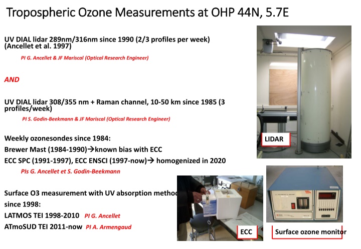
Tropospheric Tropospheric Ozone Measurements at OHP 44N, 5.7E Ozone Measurements at OHP 44N, 5.7E UV DIAL lidar 289nm/316nm since 1990 (2/3 profiles per week) (Ancellet et al. 1997) PI G. Ancellet & JF Mariscal (Optical Research Engineer) AND UV DIAL lidar 308/355 nm + Raman channel, 10-50 km since 1985 (3 profiles/week) PI S. Godin-Beekmann & JF Mariscal (Optical Research Engineer) Weekly ozonesondes since 1984: Brewer Mast (1984-1990) ECC SPC (1991-1997), ECC ENSCI (1997-now) LIDAR known bias with ECC homogenized in 2020 PIs G. Ancellet et S. Godin-Beekmann Surface O3 measurement with UV absorption method since 1998: LATMOS TEI 1998-2010 PI G. Ancellet ATmoSUD TEI 2011-now PI A. Armengaud Surface ozone monitor ECC
Tropospheric UV DIAL OHP : Characteristics and history Range : 2.5/3.5km 12/14 km depending on SNR and alignment accuracy Integration time : 1-2 h after sunset (averaging of 2000-shot files with cloud screening) LATMOS processing software : off line interactive processing (need to reduce the processing delay) NDACC archived period : 1990-2019 and Mar.-Sept.2020 To be done Jan.-Feb.2020 and Oct.2020-Jun. 2021 Ancillary data available at LATMOS : Forward/Backward Trajec. at 5 levels between 700 and 200 hPa including PV and RH along trajectories PV and density profiles from ECMWF analyses interpolated on Lidar time and position Major changes - Wavelength change in 1993 (289/299nm to 289/316 nm) - Lidar Optical Receiver installation in 2012 - YAG Laser changes in 1993 (Quantel- SURELITE), 2005 (SURELITE I to II), 2019 (SURELITE QSMART-LUMIBIRD) - Data acquisition system in 1999 and 2012 (LICEL TR20-160)
Publications since 2018 : TOAR, Lavande Campaign, Collab Univ of Ontario, DWD Steinbrecht, W., Kubistin, D., Plass-D lmer, C., Davies, J., Tarasick, D. W., Gathen, P., et al.. COVID-19 crisis reduces free tropospheric ozone across the Northern Hemisphere. Geophysical Research Letters, 48, e2020GL091987. https://doi.org/10.1029/2020GL091987, 2021 Wing, R., Steinbrecht, W., Godin-Beekmann, S., McGee, T. J., Sullivan, J. T., Sumnicht, G., Ancellet, G., Hauchecorne, A., Khaykin, S., and Keckhut, P.: Intercomparison and evaluation of ground- and satellite- based stratospheric ozone and temperature profiles above Observatoire de Haute-Provence during the Lidar Validation NDACC Experiment (LAVANDE), Atmos. Meas. Tech., 13, 5621 5642, https://doi.org/10.5194/amt-13-5621-2020, 2020. David Tarasick, Ian E. Galbally, Owen R. Cooper, Martin G. Schultz, Gerard Ancellet,Thierry Leblanc, et al. Tropospheric Ozone Assessment Report: Tropospheric ozone from 1877 to 2016, observed levels, trends and uncertainties. Elementa: Science of the Anthropocene 1 January 2019; 7 39. doi: https://doi.org/10.1525/elementa.376, 2019 G. Farhani, R. Sica, S. Godin-Beekmann, G. Ancellet, and A. Haefele, "Improved ozone DIAL retrievals in the upper troposphere and lower stratosphere using an optimal estimation method," Appl. Opt. 58, 1374- 1385, 2019 A. Gaudel, O. R. Cooper, G. Ancellet, B. Barret, A. Boynard, J. P. Burrows, C. Clerbaux, P.-F. Coheur, J. Cuesta, E. Cuevas, S. Doniki, G. Dufour, F. Ebojie, G. Foret, et al. Tropospheric Ozone Assessment Report: Present-day distribution and trends of tropospheric ozone relevant to climate and global atmospheric chemistry model evaluation. Elementa: Science of the Anthropocene 1 January 2018; 6 39. doi: https://doi.org/10.1525/elementa.291, 2018
Comparison of Lidar and ECC trend above 4 km after homogenization of ECC data base Similar standard deviation of O3 anomaly for LIDAR and ECC (larger in UTLS due to STE) Less observations and larger error on trend estimate when using a single data set Positive trends and increases of trend with altitude detected on both data sets, similar distribution of positive and negative anomalies Need homogenization of lidar data set Reprocessing of 1991 2010 profiles
Analysis of the comparisons with nighttime ECC sounding 18 soundings between 1994 and 1998 4 soundings in 2005 28 soundings between 2015 and 2021 (including the 2017/2018 LAVANDE intercomparison campaign) Useful to check if the lidar data quality has changed with time (overlap function correction, retrieval in UTLS) Day with variations in UTLS Cloud
Actions to be included in the next two years Improve the automation of the lidar monitoring at OHP (instrument switch off, alignment procedure, laser tuning) less technical staff at the station Changing the telescope and the optical emission system to improve the quality of low range observations Homogenized reprocessing of the complete data base especially for the early period (1990- 2010) - same processing software (background correction, counting desaturation, noise calculation) - same criteria for overlap function correction (2.5-4.5 km) - use of 50 ECC night-time launches since 1994 for lidar/ozonesonde comparisons - new output format to include more parameters for future reprocessing or further additional corrections Contribution to development of a common software for stratospheric and tropospheric lidar analysis (see talks of S. Godin-Beekman and G. Payen) Comparison of homogenized ozonesonde and homogenized lidar data set Question : delivery of level 1 data for processing by other groups ??