Understanding Earth's Atmosphere Composition and Layers
Learn about the composition and layers of Earth's atmosphere, including major gases, structure, and characteristics of each layer. Explore the difference between weather and climate, the elements that define them, and the concept of temperature and heat transfer in the atmosphere.

Download Presentation

Please find below an Image/Link to download the presentation.
The content on the website is provided AS IS for your information and personal use only. It may not be sold, licensed, or shared on other websites without obtaining consent from the author. If you encounter any issues during the download, it is possible that the publisher has removed the file from their server.
You are allowed to download the files provided on this website for personal or commercial use, subject to the condition that they are used lawfully. All files are the property of their respective owners.
The content on the website is provided AS IS for your information and personal use only. It may not be sold, licensed, or shared on other websites without obtaining consent from the author.
E N D
Presentation Transcript
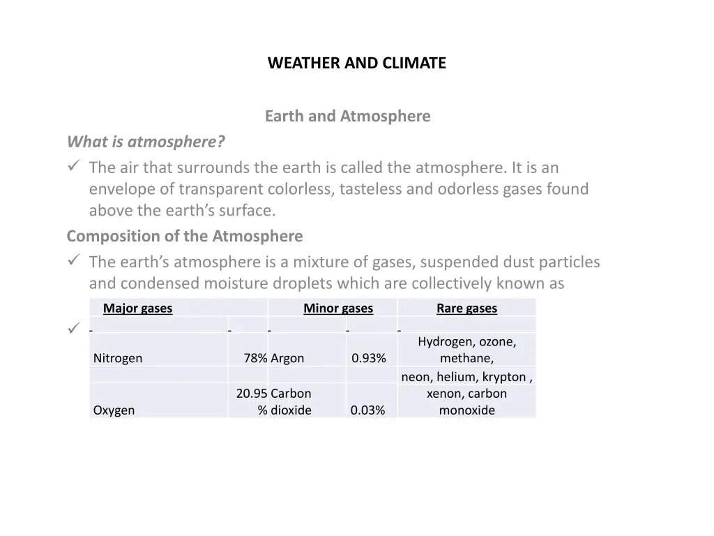
WEATHER AND CLIMATE Earth and Atmosphere What is atmosphere? The air that surrounds the earth is called the atmosphere. It is an envelope of transparent colorless, tasteless and odorless gases found above the earth s surface. Composition of the Atmosphere The earth s atmosphere is a mixture of gases, suspended dust particles and condensed moisture droplets which are collectively known as aerosols. The gases are different in their volume. Major gases Minor gases Rare gases Hydrogen, ozone, methane, neon, helium, krypton , xenon, carbon monoxide Nitrogen 78% Argon 0.93% 20.95 Carbon dioxide Oxygen % 0.03%
Cont. Structure of the Atmosphere They are: troposphere Stratosphere mesosphere and thermosphere The earth s atmosphere is divided into four layers based on temperature variation.
Atmosphere layers and their characters Name of the Average height Major characteristics layer Contains 75% of the atmospheric mass. Uniformly, temperature decreases with an increase of altitude. Extends from sea level to 8/16 kms Troposphere The top boundary is known as the tropopause, which is characterized by jet streams (high velocity winds). Has constant temperature. High concentration of ozone gases. Its upper limit is called the stratopause. Extends up ward to 50 kilometres Stratosphere It is the coldest part of the atmosphere. Its upper surface is known as the mesopause. Temperature 100oC at the top of the mesosphere. Meteorites because of friction here. Have extremely low density Very little heat can be absorbed, held or conducted. Temperature rises as high as 1200oC. The ionosphere is a layer of electrically charged particles. These electrons and ions are useful for communication because they reflect radio waves. Extends from 50 to 80/85 kilometres Mesosphere decreases to nearly burn and disintegrate Thermosphere Extends from 80/85 kilometres upward into Ionospheres exosphere space The exosphere begins at an altitude of about 500 to 700 kilometresabove the earth s surface and extends to interplanetary space.
Meaning of Weather and Climate What is weather? What is climate? How is climate different from weather? Weather is the condition of the atmosphere over a short period of time. Weather includes daily changes in precipitation, air pressure, temperature, wind, etc. Weather refers to atmospheric conditions in a given location. Climate is the average of all weather conditions of an area over a long period of time. These conditions include average temperature, air pressure, humidity, and days of sunshine for a period of 30 years. Climate tells us what it is usually like in the place where we live. Major Elements of Weather and Climate The major elements of weather and climate are: -Temperature - rainfall, - winds, -air pressure -clouds, etc.
Conti.. What is temperature? Temperature is the amount of hotness or coldness of an object. The sun is the primary heat source for the earth and its atmosphere. The sun s energy is called insolation or solar radiation, and this turns into heat energy at the earth s surface. Not all the energy that originates from the sun reaches the earth s surface. B/se of absorbetion and reflection. Heat transfer takes place in three ways. These are: Radiation Conduction Convection Temperature
Measuring and Recording Air Temperature What is the instrument that is used to measure temperatures? The instrument that used to measure temperature is called Thermometer. There are two types of thermometers: maximum and minimum thermometers. A maximum thermometer is a mercury-in-glass thermometer that has a constriction near the bulb end. When the temperature of air rises, the mercury in the thermometer expands and forces its way into the stem past this constriction. But when the bulb cools, none of the mercury above the constriction moves back into the bulb. The freezing point of mercury is 38.83oC, and the boiling point is 356.73 oC. A minimum thermometer has alcohol as its liquid, and it sets a metal index. When the temperature falls, the alcohol column drags the index towards the bulb end. When the temperature rises, the alcohol column expands and runs past the index without disturbing it.
Conti. Alcohol freezes at a temperature of negative one hundred thirty degree Celsius ( 130oC)and the boiling point is785oC. Maximum and minimum thermometers are kept in a box-like shelter which is known as a Stevenson screen. The temperature of the air changes from time to time. The changes between the highest and the lowest temperatures during 24 hours of a day is known as the daily march of temperature or the diurnal range. The changes of temperature from month to month within a year is known as the annual march of temperature. Daily average (mean) temperature: is obtained by adding the maximum and minimum temperatures of a day and dividing the sum by two. If the maximum daily temperature is 25oC, and the minimum daily temperature is 5oC, daily average temperature = 25o C + 5o C= 15oC 2 Monthly average (mean) temperature is calculated by adding all daily averages and dividing the sum by the number of days of the month. Annual average is obtained by adding the average monthly temperatures and dividing the sum by 12. Daily (diurnal) range is the difference between the maximum and minimum temperature in a day.
conti Example 2: If the maximum temperature is 25oC, and the minimum temperature is 5oC, FF Daily range = maximum minimum = 25oC 5oC = 20oC. Annual range is the difference between the temperatures of the hottest and coldest months in a year. Example 3: If the hottest month is 40oC, and the coldest moth is 10oC, Annual range = 40oC ( 10oC) = 50oC
Table 2.5:Average annual temperature for Addis Ababa Months J F M A M J J A S O N D Annual Max.Temp (oC) 23.3 24.3 24.8 24.2 24.4 22.8 20.6 20.6 21.3 22.3 22.6 22.8 Annual Min.Temp (oC) 9 10.8 11.6 12 12.3 11.2 11.3 11.2 11 9.9 8.7 8.1 Activity 2.12 By referring to Table 2.5, a Calculate annual range of temperature. b Calculate annual average (mean) temperature.
Conti What is rainfall? Rainfall is liquid precipitation. Any moisture that falls from the clouds towards the earth s surface is called precipitation. Rainfall Precipitation may occur in the form of rain, snow, hail, sleet and drizzle. Precipitation is part of the water cycle or hydrological cycle. The water cycle begins as water is changed from liquid to vapour by evaporation and transpiration of water vapour. Once water vapour is formed, it expands and cools. Then, condensation occurs, forming clouds, and the water falls as snow, sleet or rainfall. The whole process is powered by solar energy and is repeated continuously. This whole process is called the hydrological cycle.
conti Evaporation is the process by which liquid water is converted into gases. Transpiration is the transfer and change of water from plants to water vapour in the air. Evapotranspiration is the combined loss of water through the process of evaporation and transpiration. Condensation is the process by which vapour becomes liquid. Sublimation is the process in which ice changes into water vapour without first becoming a liquid, and vice versa. Water is a unique substance, because it can exist in three states as liquid, solid and gas) in the atmosphere.
Types of rainfall What are the types of rainfall? Explain their formation. Rain is given three different names according to the different ways in which moisture is forced to rise. They are: Convectional rainfall Orographic (relief) rainfall Cyclonic or Frontal rainfall Convectional rainfall: When the ground surface is heated by the sun, the air above it is warmed up. At high altitudes, the water vapour cools, condenses to form clouds and falls as rain. This type of rainfall is common in humid areas where temperature is high throughout the year. Orographic (relief) rainfall: occurs when moist air is forced to rise over mountains. As it rises, it cools, then condenses and falls as rain. Almost all orographic rainfall falls on the windward side of mountains.
Conti. Cyclonic or Frontal rainfall when two air masses (warm and cold) meet, they do not mix freely with each other. They remain separated with a boundary surface between them. The warmer and less dense air is forced to rise over the colder and heavier air. As the warmer air rises, it cools and condenses. Then clouds form and rain falls. The place where warm air and cold air meet is called a front. Frontal rainfall is very common in the middle and high latitudes (60o north and south from the equator). Rainfall is measured using an instrument called rain gauge.
Air Pressure The air around us has weight. This weight exerts pressure on the surface of the earth. We call this atmospheric pressure. Atmospheric pressure is not the same all over the earth, and it is not the same even in one place all the time. Pressure is measured by a mercury barometer. Normal pressure, at sea level, is about 760 mm/1013 mb. The distribution of pressure over the earth s surface depends on 1.the altitude of places above sea level and 2. most importantly, on temperature. Pressure decreases with an increase in altitude. This explains why air pressure is highest at sea level and decreases with increasing altitude. High temperature makes air expand, so that it has a lower density and pressure. Low temperature makes the air to contract, resulting in a higher density and creating an area of high pressure.
Conti The distribution of air pressure over the globe is known as the horizontal distribution of pressure. Pressure distribution can be shown on a map. Lines connecting all places that have the same pressure are called isobars. Wind What is wind? Wind is air in horizontal motion. Winds have speed and direction. Wind force (speed) and wind direction are affected by Pressure gradient Frictional force Coriolis force On weather maps, pressure is indicated by drawing isolines of pressure, called isobars. The difference in distance between Isobars is called the pressure gradient. If the isobars are closely spaced, we can expect the pressure gradient force to be great, and wind speed to be high. In areas where the isobars are spaced widely apart the pressure gradient is low and light winds normally exist. High speed winds develop in areas where isobars are closer.
Conti Wind speed is often measured with animometer. Winds are named according to the compass direction of their source. Wind direction is measured as the direction from where wind comes. For example, a southerly wind comes from the south and blows to the north. Direction is measured by an instrument called wind vane. Deflection of Winds Due to the Earth s Rotation Because of the earth s rotation, the direction of wind blow may not be at right angles to wind isobars, but rather at slanting angles to them. This deflection is caused by friction. The speed of wind also affects the amount of deflection. The force which affects the direction of movements of winds is called the Coriolis force. The deflection is to the right in the Northern Hemisphere and to the left in the Southern Hemisphere.
Conti.. Cyclones are atmospheric disturbances which involve a closed circulation about a low-pressure center. They move inward, anticlockwise, in the Northern Hemisphere and clockwise in the Southern Hemisphere. Cyclones are commonly known as lows or low pressure areas. Anti-cyclones are vast areas of high pressure which have a diverging system of surface winds. The winds in anti-cyclones blow outward in the anti-clockwise direction in the Southern Hemisphere and in the clockwise direction in the Northern Hemisphere. Anticyclones are commonly called highs or high pressure areas.
Types of Winds There are three types of surface winds. They are: Planetary winds and their relationship with pressure belts: Planetary winds blow over large areas of the earth s surface. They are closely associated with the world pressure belts. Winds blow from areas of high pressure to areas of low pressure. The most common planetary winds are trade winds, westerlies and polar easterlies. Monsoon winds: They are seasonal winds whose movements are controlled by pressure that differs during different seasons. Monsoon winds are very common in South and South East Asia. Seasonal changes in the direction of these winds are caused by the unequal heating of land and water surfaces. The direction of monsoon winds changes between summer and winter. Local winds: They affect only limited areas and blow for a short period of time. They affect climate conditions on a small scale. Local winds are caused by the nature of the physical features of the area. The main local winds are: Land and sea breezes Mountain and valley breezes
Conti Land and sea breezes: These winds are common along coastal areas. These winds change their directions daily and affect very small areas. So low pressure is formed on the land, while it is relatively high on the sea. Wind blows from the sea towards the land. This is known as a sea breeze. At night the land is colder than the sea. So low pressure develops over the sea. The wind blows from land towards the sea. This is known as a land breeze. Mountain and valley breezes: Mountain and valley breezes arise from contrasts in temperature between a valley floor and mountain slopes. During the day the air at the bottom of the valley becomes warmer. As a valley breeze. At night the wind over the slope of the mountain becomes cool. Then this cooler and heavier mountain air slides down slopes towards the valley. This is called a mountain breeze.
Conti cloud What are clouds? A cloud is a dense concentration of very fine invisible water droplets, sleet or ice crystals. Clouds are formed by the condensation of water vapour below the dew point in the atmosphere. Controls of Weather and Climate The energy that the earth receives from the sun is not distributed evenly. Many factors affect the distribution. These include Latitude altitude, distance from the sea cloud cover, ocean current, planetary winds and pressure.
NATURAL REGIONS OF THE EARTH What is a region? A region is a part of the earth s surface which has similar physical elements and to some extent similar human activities. The earth provides many environments that vary in natural elements, such as relief, climate, vegetation, soil, etc. A region can be natural or human-made, can be small or large, and does not have a clear boundary. Major Natural Regions of the Earth The earth can be divided into three major temperature zones. These are: Tropical (hot) zone. Temperate zone. Frigid (cold) zone
Tropical (Hot) Zone What is the location of Tropical zone? Explain the general characteristics of temperature? The tropical or hot zone is the zone between the Tropic of Cancer (23 oN) and Tropic of Capricorn (23 oS). The tropical zone is characterized by high temperature throughout the year. The annual average temperature is above 20oC, which decreases pole wards from the equator. Rainfall decreases and becomes seasonal as one moves away from the equator. Agriculture and mining are the major economic activities of the zone. The tropical zone is divided into four sub-regions. These are: the equatorial rainforest region the savanna grassland region the desert region the tropical monsoon land
The Equatorial Rainforest Region Location They are found in the lowland areas within 6o north and south of the equator. The main areas in the world include. The Amazon Basin The Congo Basin Southern Malaysia and some Indonesian islands The equatorial rainforest region does not form a continuous belt around the earth. It is broken by high altitudes in East Africa and South America. The Amazon Basin is the most extensive area. Climate Equatorial rainforest region has uniformly high temperature and heavy rainfall throughout the year. The mean annual temperature is about 27oC, and the annual range of temperature is less than 3oC. But the daily range is greater than the annual range of temperature.
Conti The total annual rainfall is very high, usually between 1500 mm and 2500 mm. All months have rainfall with a small variation in amount. Conventional rain fall is the most common rain fall type in this region. Natural Vegetation The region has dense, tall, broad-leafed and evergreen trees. The high temperature and abundant moisture of this region makes plants growth continuous. The ground is covered with tropical rainforest, the most luxuriant type of natural vegetation in the world. Most of the trees are hardwood, such as rosewood, ebony, and mahogany, which are valuable for making durable furniture. There are three layers in the forest: The top layer: This is made of giant trees, often over 50 m high. They do not grow close together. They have very few branches except at the top. The middle layer: This is made of the trees that are from 20 m to 40 m high. It is the main part of the forest. The lower layer: This is made of the smaller, younger trees. Trees are closely spaced and interlaced with climbing vines called lianas. There are as many as about 3,000 species within a few square kilometres.
Conti The Equatorial rainforest is inhabited by varieties of animals, such as insects, birds, reptiles, mammals. Most mammals are arboreal. They are small in size and are tree climbing, example apes, monkeys, bats, squirrels, etc. Water body animals, such as crocodiles, alligators, hippopotamuses, fish, etc, are also available. Human Activities The human activities found in equatorial rainforests include: primitive hunting and gathering shifting cultivation plantation agriculture, and mining. Wild Animals
Tropical Deserts Location Deserts are almost barren lands. The tropical hot deserts are located between 15o to 30o north and south latitudes of the equator. The largest hot desert is the Sahara Desert. There are also other important deserts such as the Kalahari, Atacama, Colorado, Arabia, Thar and Australian deserts. Deserts are formed due to their location What is a desert? Where are the major tropical hot deserts? in the trade-wind belts on the leeward side of high mountains in the interior of continents along cool ocean currents Most deserts arise due to atmospheric wind conditions.
Conti Deserts are located on the western margins of continents, except for the Sahara Desert, which is in North Africa and extends to the northeastern coast of the African continent. Climate The main characteristics of desert is that the climate is hot throughout the year, and there is very low and unreliable rainfall (not more than 250 mm per year). Temperature ranges from 25oC to 40oC or above during the daytime, and they can fall even below 0oC during the night, due to the absence of clouds. The winds are warm and dry. Vegetation The climate of the hot desert is not favourable for plant growth. However, there are some plants that have a special way of behaving or special features (adaptations) which enable them to survive. Plants in deserts have long roots, few or no leaves, hard bark and an oily leaf surface.
Conti Plants in deserts have long roots, few or no leaves, hard bark and an oily leaf surface. These features help the plants to extract every drop of moisture from the soil and reduce the loss of water by evapotranspiration. These are called xerophytes. Xerophytes are woody and thorny plants, grasses and herbs, for example cacti. Animal life Animals such as gazelle, hare, fox, snakes, lizards, etc are commonly available in the desert region. For the desert people camel is their best companion. It has special adaptations, which helps it to survive the desert. Human Activities: The major economic activities found in the hot deserts are pastoralism, crop cultivation and mining. Pastoralism is the grazing of animals. Many of the desert people practice a nomadic way of life. Nomads do not live in one area. They move with their animals from place to place looking for water and pasture. They keep animals like camels, sheep, goats, cattle, etc.


 Zone")