Understanding the Role of Tourist Information Centers and Geography
Explore the role of a tourist and the importance of tourist information centers in gathering geographical data and understanding surroundings. Learn about latitude, longitude, and geographical features through interactive maps. Discover how to utilize maps and information resources effectively during travel.

Download Presentation

Please find below an Image/Link to download the presentation.
The content on the website is provided AS IS for your information and personal use only. It may not be sold, licensed, or shared on other websites without obtaining consent from the author. If you encounter any issues during the download, it is possible that the publisher has removed the file from their server.
You are allowed to download the files provided on this website for personal or commercial use, subject to the condition that they are used lawfully. All files are the property of their respective owners.
The content on the website is provided AS IS for your information and personal use only. It may not be sold, licensed, or shared on other websites without obtaining consent from the author.
E N D
Presentation Transcript
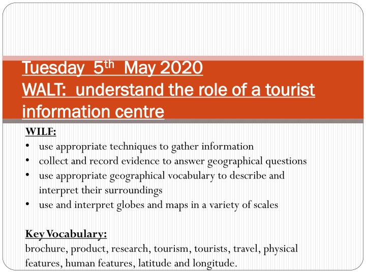
Tuesday 5 Tuesday 5th thMay 2020 WALT: understand the role of a tourist WALT: understand the role of a tourist information centre information centre WILF: use appropriate techniques to gather information collect and record evidence to answer geographical questions use appropriate geographical vocabulary to describe and interpret their surroundings use and interpret globes and maps in a variety of scales May 2020 Key Vocabulary: brochure, product, research, tourism, tourists, travel, physical features, human features, latitude and longitude.
Starter: Recap- tell me about your holiday What do you remember about them? What is a tourist? What did you need to help you as a tourist?
Visit the link: https://www.google.co.uk/intl/en_uk/ earth/ Explore this interactive world map. Start by finding your school and local area. Next, Where have you been on holiday? Using the map, identify where this is? (You can zoom into the map to look more closely at the features). You can identify the different geographical regions and features that you can see- both physical (beaches, forests, cliffs, mountains, etc.) and human (cities, towns, farms, piers, railways, roads, etc.).
If you are using Google Earth, press (CTRL) and (L) on your keyboard to bring up the map grid. This will show lines of latitude and longitude, the Equator, the Tropics of Cancer and Capricorn, the Arctic and Antarctic circles and the Prime Meridian. The positioning of the Equator and the Tropics relates to where the sun is directly overhead at certain times of the year. Due to the Earth s tilt and facing to the sun, these areas get the most direct sunlight. The area between the tropics has a higher degree of humidity/ precipitation than other areas (hence the term) and the Equator marks the centre of the Tropics. Like a graph, the Prime Meridian and the Equator are like an xand y axis, dividing the world into hemispheres. Lines of latitude (north-south) and longitude (east-west) are like grid references, that geographers use to give specific locations of countries and features. A country s latitude (how far north or south of the Equator it is located) may affect its climate.
Key thinking points for todays lesson: (answer these questions in full answer these questions in full sentences sentences) 1) 1) Where would you go to find Where would you go to find information when you visit a new information when you visit a new city? city? 2) 2) Why are maps useful? Why are maps useful? 3) 3) What information do they give us? What information do they give us? 4) 4) What if the tourist information was What if the tourist information was closed for a day , what could you closed for a day , what could you use? Explain how will you use it? use? Explain how will you use it?
Different types of holidays Beach resort Walking/activity holiday Skiing holiday City break Can you think of any other different types of holidays?
Different types of tourism: Tourists can be divided into different categories. This can be on the basis of which types of places they like to visit or the type of activities they like to be involved in. Beach holidays, eg in Spain and the Maldives. People can relax on the beach or take part in water sports. Outdoor adventure, eg skiing and walking in the European Alps or the Rocky Mountains of North America. Cultural/historic, eg people like to visit historic sites, art galleries and museums in cities such as Rome and Paris. In cities like New York and London they can go shopping or see shows. Ecotourism, eg small numbers of people go trekking in the Amazon rainforest or on whale and dolphin conservation holidays in Scotland. This type of tourism is designed to be sustainable.
Task: Making a brochure. Think about what makes each country/location unique as a holiday destination. Consider: The weather and climate The country s history and culture Tourist attractions Physical features (mountains, beaches, volcanoes, forest, coastline, etc.) (Hint- Easier to compare a beach resort, a walking/activity holiday, a skiing holiday, a city break: like Madrid or Barcelona)
Task Select only one country or city. What that tourist is looking for in their holiday (e.g. skiing, walking, history/culture, beach, water sports, rock climbing, jungle exploration, etc.) Their preferences for climate ( I don t mind it being too cold . My skin burns easily . I prefer walking in the sun to the rain! ) The time of year they want to travel (Summer, Winter, etc.) Remember to upload your work onto Google classroom.
Some useful support websites include: blueplanetbiomes.org/climate.htm 'Blue Planet provides essential facts about weather and climate including definitions and maps which identify climatic classifications and climate zones. climate-zone.com 'Climate Zone provides information about the climate and geography of every country in the world. Users can zone into the country of their choice. timetemperature.com 'Time Temperature gives details of temperatures around the world in real time. climate- charts.com/World-Climate-Maps.html provides a range of world climate maps, including average temperatures and total rainfall
Plenary-Think-Share-Write What What information information did them them predict predict the each each location? location? What What facts facts did search search to to support/challenge support/challenge their Was Was it it possible possible to to please were were compromises compromises necessary? the maps maps provide, the weather/climate did the weather/climate and provide, to to help and features features of of help did they they discover from their their predictions? predictions? each of of the the tourists necessary? discover from their later later internet internet please each tourists or or


 and (L) on")