Unveiling the WIVERN Mission: Observing Global In-Cloud Winds and Precipitation
The WIVERN mission, part of the ATMOS-2021 Earth Explorer program, aims to observe global in-cloud winds and precipitation using advanced radar technology. With a primary focus on in-cloud winds utilizing cloud particles as tracers, WIVERN also targets global rainfall, snow, cloud water content, and cloud depth. Led by experts from various institutions, including the University of Reading and Politecnico Torino, WIVERN's innovative radar concept and global sampling approach promise to enhance our understanding of atmospheric dynamics. The mission incorporates cutting-edge techniques to measure Doppler shift accurately and operates in a 500km orbit with an 800km wide ground track. WIVERN's radar system provides detailed insights into wind patterns within tropical cyclones, precipitation rates, cloud profiles, and more, contributing significantly to climate research and forecasting.

Download Presentation

Please find below an Image/Link to download the presentation.
The content on the website is provided AS IS for your information and personal use only. It may not be sold, licensed, or shared on other websites without obtaining consent from the author. If you encounter any issues during the download, it is possible that the publisher has removed the file from their server.
You are allowed to download the files provided on this website for personal or commercial use, subject to the condition that they are used lawfully. All files are the property of their respective owners.
The content on the website is provided AS IS for your information and personal use only. It may not be sold, licensed, or shared on other websites without obtaining consent from the author.
E N D
Presentation Transcript
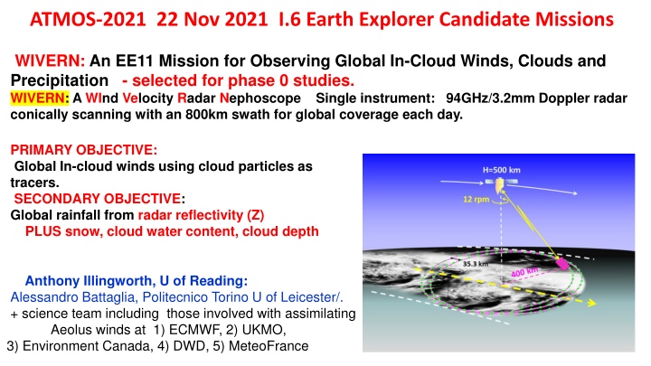
ATMOS-2021 22 Nov 2021 I.6 Earth Explorer Candidate Missions WIVERN: An EE11 Mission for Observing Global In-Cloud Winds, Clouds and Precipitation - selected for phase 0 studies. WIVERN: A WInd Velocity Radar Nephoscope Single instrument: 94GHz/3.2mm Doppler radar conically scanning with an 800km swath for global coverage each day. PRIMARY OBJECTIVE: Global In-cloud winds using cloud particles as tracers. SECONDARY OBJECTIVE: Global rainfall from radar reflectivity (Z) PLUS snow, cloud water content, cloud depth Anthony Illingworth, U of Reading: Alessandro Battaglia, Politecnico Torino U of Leicester/. + science team including those involved with assimilating Aeolus winds at 1) ECMWF, 2) UKMO, 3) Environment Canada, 4) DWD, 5) MeteoFrance
WIVERN RADAR CONCEPT 500km orbit 800km wide ground track: 41.6 off zenith at surface One rotation in 5 seconds (12 rpm) - move 35km along track For representative winds suitable for data assimilation accurate 2m/s averaged 20km along footprint track. 3m antenna (maximum possible with current launcher) 94GHz for a narrow beam: Beamwidth at the surface 800 m. Pulse length 500m (3.3 s) 1. DOPPLER line of sight winds using cloud particles as tracers. Winds inside tropical cyclones + deepening Atlantic (and Mediterranean) depressions Complementing Aeolus Doppler lidar clear-sky and cloud top winds (+ Aeolus follow on) 2. RADAR REFLECTIVITY precipitation rate, cloud profiles, cloud ice water content 3. BENCHMARK for climate record of cloud profiles, global precipitation. (continuation of CloudSat record since 2006, and EarthCARE 2023 onwards + winds)
GLOBAL SAMPLING: EACH 30 km BOX IS VISITED WITH A CURTAIN OF RADAR DATA CROSSING IT EACH DAY (ON AVERAGE) UP TO +/-82DEG LATITUDE 800km swath Sub-satellite point moves at 7km/s. Forward view 35km movement along track per circular scan (5 secs/12rpm) On the average, each 30km x 30km box has at least one track across it each day to provide wind profiles and rain rates. Rear view 3
BUT HOW TO MEASURE A DOPPLER SHIFT OF 1m/s ? Speed of light is 3 108 m/s Round trip so: Need to measure change in frequency of return to 1 part in 1.5 108 ONE PART IN 150 MILLION. 3.3us pulse at 94GHz only transmit about 350 waves. Direct Detection not possible. 4
DOPPLER RADARS ON THE GROUND SCANNING AZIMUTH HAVE BEEN USING PULSE-PAIR PP TECHNIQUE TO ESTIMATE VELOCITIES OF PRECIPITATION FOR MORE THAN FIFTY YEARS FROM THE GROUND: Transmit a pair of pulses: Detect change in phase shift, , from the two returns. The maximum unambiguous velocity (VFOLD) occurs when = +/- 180 and the particles have moved +/- /4. Ground base weather radar: if = 5.6cm /4 = 14mm If pulse every 0.5 msec (so max unambiguous range is 75km). Folding velocity 14mm/ 0.5msec +/- 28m/s or +/- 100km/hr FROM SPACE MUST USE 94 GHz/3.2mm to have a 1km footprint on the surface: /4 = 800 m so for 40m/s need pulse separation of just 20 sec Folding velocity of 800 m/20 sec = +/ 40m/s or +/- 144km/hr 20 sec pulse separation is just 3km in range so how do you know which pulse you are receiving? 5
DOPPLER FROM SPACE? POLARISATION DIVERSITY PULSE PAIR PDPP Use two H & V pulses separated by just 3km/ 20 sec are effectively labelled : they transmit, scatter and are received independently. RANGE PULSE SEPARATION 20 sec OR 3km slant path (2.3km in the vertical TIME H pulse H V Pulse 20 s later In that 20 secs the target moves /4 in range /4 V = H + 180 FOLDING VELOCITY: 800 m in 20 sec = 40m/s. If measure phase to 1deg accuracy, better than 0.25m/s Very simple technique for radar. Won t work for lidar (Aeolus). Aeolus: = 0.355 m Wavelength is 10,000 times smaller. /4 is a radial movement of ~ 0.1 m. 6
ESA has funded 2 PDPP systems: one ground based and one airborne on the Canadian Convair 850 They transmit H-V 20 s pulse pairs alternating with from 250 sec H-H pulse pairs, the TRUTH. Extensive observations confirm the PDPP velocity is the same as PP velocity. EXACTLY THE SAME PDPP SYSTEM WILL BE USED ON THE WIVERN SATELLITE GROUND BASED- CHILBOLTON UK CANADA NCR CONVAIR 850 AIRCRAFT MANY HOURS OF DATA TO CHECK H-V DOPPLER GIVES RELIABLE WINDS CROSS TALK. DEPOLARISING TARGETS, PULSES 3km APART, VERY LARGE CHANGE IN Z OVER 3km, the return from the high Z regions will give a GHOST ECHOES IN THE LOW Z REGION Yes, but the cross-talk signal will have random phase MAKE WINDS NOISIER BUT NO BIAS 7
GHOST ECHOES FROM THE GROUND (60m/10 Sec resolution) CONFIRMS NOISIER WINDS. SIGNAL STRENGTH 4.5 km slant path GHOST 10dB HIGHER than signal 4.5 km slant path ICE SIGNAL 0dB 1.5Kkm slant path RAIN SIGNAL 35dB 4.5km HEIGHT WINDS RED LINE TRUE 250us VELOCITY BLACK LINE H-V 20usec noisier when 10dB ghost present WINDS AT 4.5KM HEIGHT EVERY 10 SECONDS BLACK LINE RMS ERROR up to 0.5m/s GREEEN LINE ESTIMATED RMS ERROR FROM THE CORRELATION OF THE OBSERVED H-V RETURNS 8
HERITAGE: CloudSat CloudSat: first 94GHz radar in space. Launch 2006. Radar transmitter performed beyond expectations since launch in 2006 and after 15 years is not yet using the spare tube! Nadir pointing: 1.4km wide swath. CloudSat measured radar reflectivity (Z) profiles (no Doppler) and has provided a global climatology of cloud reflectivity profiles WIVERN is low risk will use the same 94GHz klystron, same prf (4kHz) same pulse power, same pulse length (3.3us/500m) as CloudSat. Use two klystrons: one for H, one for V DOPPLER PERFORMANCE OF WIVERN Expect that we can measure the horizontal component of the line of sight (HLOS) wind speed with a precision of 2m/s for 20 km along track integration for targets with Z > -20dBZ Using the known climatology of global profiles from CloudSat We can predict WIVERN should measure > 1 million winds per day From the vertical gradients of Z ghosts will be very rare when observed from space Ghost from the depolarising surface will cause noisier winds at a slant path height of 3km. NEED MORE CANADIAN AIRCRAFT FLIGHTS IN PHASE ZERO TO QUANTIFY THIS EFFECT.
WHAT ABOUT ESTIMATING RAINFALL WITH WIVERN? Very difficult from space Many satellite-based techniques but how are they validated and what are the errors? The 94GHz radar on CloudSat provides the best global rainfall statistics. Derived from the drop in the sea surface radar return the path integrated attenuation. CloudSat rainfall data has led to a change in the global OLR of about 10 to 20W/m2 Stephens et al. Nature 2012. ?10
WHAT ABOUT ESTIMATING RAINFALL from Wivern? Very difficult from space what are the errors? GEOMETRY OF THE WIVERN PULSE VOLUME : 500m pulse length 805m beamwidth. VERTICAL RESOLUTION 640m Sample volume red box, Canadian colleagues (Wolde & Nguyen) have WIVERN pulse compression design for use on the CONVAIR 850. This would give a Z measurement for every 100m along the slant path rather than 500m at present Simulations suggest that the Z gradient and hence the rain rate can be derived sufficiently accurately (Also extra 8dB suppression of cross talk!) Try this with CONVAIR a/c in phase zero Potential for accurate global rainfall over sea and land. ?11
WIVERN CHALLENGE ANTENNA POINTING KNOWLEDGE THE ROTATING ANTENNA induces a COMPONENT of the SATELLITE MOTION (7 km/s) with an amplitude of 5,000 m/s superposed on the OBSERVED DOPPLER. Need antenna pointing knowledge to 40 rad over 10 seconds (three sigma) to reduce the component to 0.2m/s (antenna beamwidth is about 1 mrad) PRELIMINARY INDUSTRY STUDY SUGGEST THIS CAN BE DONE. CRUCIAL TO THE THE MISSION. NEED MORE INDUSTRIAL STUDIES IN PHASE ZERO 12
WMO REQUIREMENTS FOR HORIZONTAL WINDS FOR GLOBAL WNP WMO REQUIREMENTS SURFACE RAINFALL FOR GLOBAL WNP THRESHOLD, 1mm/hr 50km resolution BREAKTHROUGH, 0.2mm/hr 15km resolution GOAL 0.1mm/hr 5km resolution Can be achieved by rain gauges but only at a point: Not achieved by ground-based radar networks (UK 1km resolution every 5 mins). What about WIVERN? 14
WIVERN complements Doppler wind lidar winds by observing in areas they cannot see within optically thick clouds thus allowing the full 3D-winds to be captured. The WIVERN mission will provide: i) unprecedented wind observations inside tropical cyclones and mid-latitude windstorms that will routinely reveal the dynamic structure of such destructive systems; ii observations of convective motions to validate their representation in NWP models; iii|) global profiles of cloud properties and precipitation over an 800 km swath that will better quantify the hydrological cycle and the atmospheric and surface energy budget; iv) first direct observation of tropospheric dynamics to underpin predictions of transport and dispersion of trace gases and pollutants in atmospheric chemistry and air quality models. v) WORK IN PROGRESS: accurate estimates global rainfall over sea and land. 15


")