USGS Water Mission Area GOES Usage Report
SWaTH network consists of coastal stations, rapid deployment gages, storm-tide sensors, wave sensors, and more to monitor severe weather events along the Northeast Coast. Explore alternatives like cellular and Iridium for data transmission.

Download Presentation

Please find below an Image/Link to download the presentation.
The content on the website is provided AS IS for your information and personal use only. It may not be sold, licensed, or shared on other websites without obtaining consent from the author.If you encounter any issues during the download, it is possible that the publisher has removed the file from their server.
You are allowed to download the files provided on this website for personal or commercial use, subject to the condition that they are used lawfully. All files are the property of their respective owners.
The content on the website is provided AS IS for your information and personal use only. It may not be sold, licensed, or shared on other websites without obtaining consent from the author.
E N D
Presentation Transcript
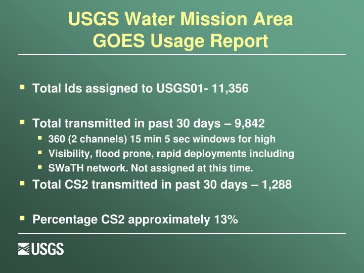
USGS Water Mission Area GOES Usage Report Total Ids assigned to USGS01- 11,356 Total transmitted in past 30 days 9,842 360 (2 channels) 15 min 5 sec windows for high Visibility, flood prone, rapid deployments including SWaTH network. Not assigned at this time. Total CS2 transmitted in past 30 days 1,288 Percentage CS2 approximately 13%
Special Projects Surge, Wave, and Tide Hydrodynamic (SWaTH) Network (SWaTH) eastern seaboard Green Ocean Amazon (GOAmazon)- Dr. Dennis G. Dye- AZ WSC Afghanistan-COE-Rapid Deployment Gage Type 4 (RDG-4) Mongolia-Interested in water quality monitoring near metro area. South Dakota WSC
SWaTH Entire proposed network consists of about 1,000 sites: 76 non-USGS stations 162 coastal stations/tidal streams 60 rapid-deployment gages 384 temporary storm-tide sensors 217 temporary wave sensors 102 temporary barometric-pressure sensors Pre-emptive network Northeast Coast from Virginia to Maine Nor easters and tropical storms of varying magnitude Data distributed through an online mapper termed Short-term Network
Cellular Working with Verizon Wireless to develop a private data network with prioritization. Tentative- Each WSC will fund own and control own usage under a family or shared data plan. Higher tier level support structure. Experience has been good. Better overall coverage/availability. Approval gained through IT/IOS. At Reston for final workups. Cellular users have experienced good results across the board. Good feedback. Several projects/small networks in existence in various areas around country for WMA.
Iridium Interest growing, esp. For two-way comms, command and control options, on-demand data, backup to GOES. Working with DOD/DISA on use of gateway (NOS and Sutron have assisted by providing info and/or contacts). DISA working toward restructure of costs in order to attract more Federal users. Our best option appears to be falling under existing National Park Service plan with DISA. They are in favor and are working with us to make happen.
Meteorburst Meteorburst- Maiden Rock Communications (was Meteorcomm) has developed newer model meteorburst radio with IP capability, better power management options. Our use is the ELOS two-way capability of the radio for networks. Most prolific for us is in Austin TX flood warning. 50 mile radius and expanding. Also, San Antonio is looking into this option.
Spectrum Reaching out to WSC s with information via memo from Director of Water. Information will contain a summary of what is going on and what might be coming down the line. Will also contain information that can be passed along to cooperators to inform them of the threat as well as provide possible avenues (FCC comments, contact representatives) for them to express concerns.
Training Hydrologic Instrumentation Facility offers 3 courses taught 2X per year: Basic Electronics and troubleshooting for gaging stations - 18 seats Data Collection Platform training 18 seats Water Quality Instrumentation 16 seats Priority based on availability: USGS, OFAs Contact: Richard Pardee at rwpardee@usgs.gov