VIIRS Product & PGE Status Update
Stay informed on the latest reprocessing and forward processing updates for various VIIRS SNPP V1 products and PGEs, including Land Surface Reflectance, Vegetation Index, LAI-FPAR, BRDF-Albedo, Active Fire, Snow, and Sea-ice. Get insights into the current processing stages and future plans for VIIRS NRT and GIBS products, as well as the reprocessing plans for SNPP VIIRS. Keep track of the evolving technology and timelines in the world of Earth observation data processing.

Uploaded on | 0 Views
Download Presentation

Please find below an Image/Link to download the presentation.
The content on the website is provided AS IS for your information and personal use only. It may not be sold, licensed, or shared on other websites without obtaining consent from the author. If you encounter any issues during the download, it is possible that the publisher has removed the file from their server.
You are allowed to download the files provided on this website for personal or commercial use, subject to the condition that they are used lawfully. All files are the property of their respective owners.
The content on the website is provided AS IS for your information and personal use only. It may not be sold, licensed, or shared on other websites without obtaining consent from the author.
E N D
Presentation Transcript
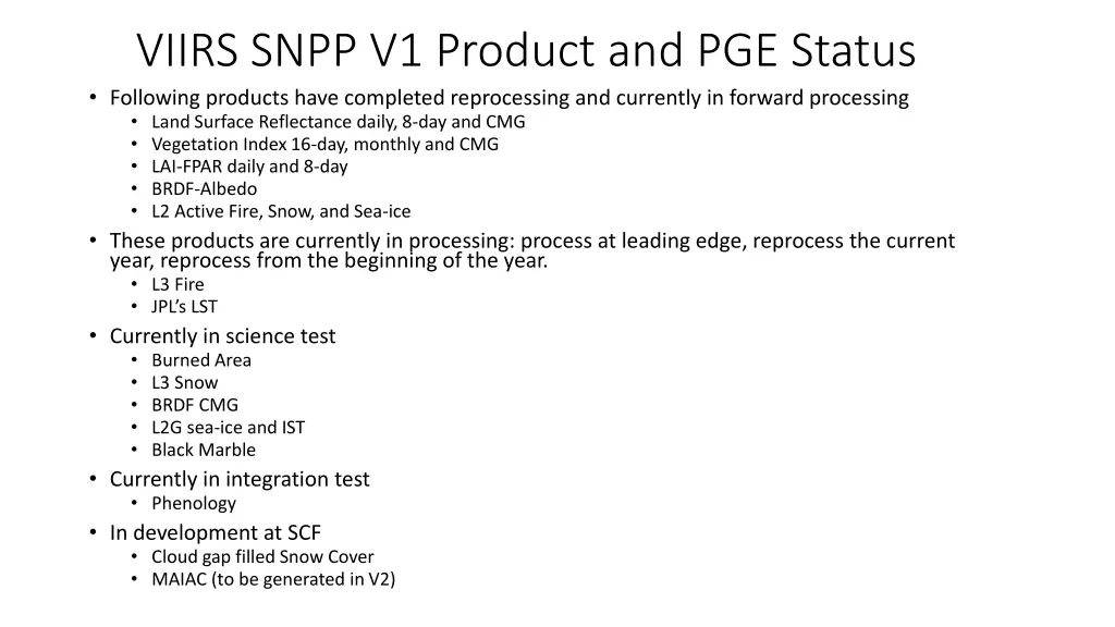
VIIRS SNPP V1 Product and PGE Status Following products have completed reprocessing and currently in forward processing Land Surface Reflectance daily, 8-day and CMG Vegetation Index 16-day, monthly and CMG LAI-FPAR daily and 8-day BRDF-Albedo L2 Active Fire, Snow, and Sea-ice These products are currently in processing: process at leading edge, reprocess the current year, reprocess from the beginning of the year. L3 Fire JPL s LST Currently in science test Burned Area L3 Snow BRDF CMG L2G sea-ice and IST Black Marble Currently in integration test Phenology In development at SCF Cloud gap filled Snow Cover MAIAC (to be generated in V2)
VIIRS NRT Products generated within 2 to 2.5 hours after the acquisition of the data Plans to port VIIRS PGEs for all heritage MODIS products operational for NRT MODIS Processing uses session based PDS files Most products use the operational PGEs used in the V1 reprocessing Products are near science quality. Currently in processing LSR, Snow, Sea-ice, Active Fire, BRDF-Albedo Currently in testing LST will use NCEP data instead of MERRA2 used in standard processing.
VIIRS GIBS Generate the images of product at the native product resolution and deliver to GIBS Plans to generate images of V1 VIIRS land products where images are available for the heritage MODIS product. Currently operational Active Fire Corrected Reflectance Issue Need to communicate to the user the product used to produce the images posted on Worldview. Be able to replace the images with images from the latest collection processing.
Land SIPS: V2 SNPP VIIRS Reprocessing Plan V2 is all in HDF5 including the intermediates that are currently in HDF4 in the on-going V1 reprocessing. Land SIPS is currently updating the libraries and the upstream PGEs (land aerosol, land cloud mask, grid_to_gran) to handle HDF5 inputs and generate HDF5 outputs. Science teams need to update L2 PGEs to work with the NASA L1B in HDF5/netcdf4 format. NASA L1B and Geo products are available from AS 5110 L3 PGEs to read and output all products in HDF5, exception are ancillaries from other data source. Metadata may need to be streamlined watch for guidance on list of metadata and format. Target Timeline for the reprocessing of SNPP VIIRS is Spring 2019, i.e. after completion of the on-going V1 reprocessing.
Land SIPS: J1 VIIRS Reprocessing Plan Land SIPS is funded to generate L1B and land continuity products from J1 VIIRS Test of J1 VIIRS L1B using post-launch LUT delivered by VCST and cross calibration of J1 and SNPP VIIRS is in progress. V2 SNPP VIIRS PGEs will be ported to read and process J1 VIIRS data. Processing can start only after or along with SNPP VIIRS V2 reprocessing. VIIRS Science Team isn t funded to support J1 products at this time VCST and operational Q/A teams will support on going Q/A of the products Assessing validation status can only be based on cross comparison with SNPP Issues that arise from instrument artifacts that require adjustment to science software to correct may require an augmentation of PI funding At present the only major difference between the VIIRS instrument, we are aware of is in the day/night bands and a detector issue in I3.
Maintenance and use of Upstream Products Cloud Mask IDPS version of the algorithm, not calibrated and maintained. Known to have significant commission and omission errors Should land use cloud mask from atmosphere SIPS when it becomes available? Aerosol IDPS version of the algorithm, augmented by changes recommended by LSR team Land Cover Currently using MODIS land cover product in processing of LAI-FPAR QSTLWM (Quarterly Surface Type Land Water Mask) An hybrid product developed by BU for use in IDPS processing Currently used by Cloud Mask and Active Fire in the Land SIPS processing stream This is the LWM propagated downstream to all products Who is the owner and what about the maintenance of this product? Land Water Mask The MODIS heritage LWM is in the VNP03 product. In heritage MODIS processing all L2 propagate LWM form the geolocation file (MxD03) this LWM is maintained and owned by UMD Current VIIRS processing doesn t use this at all. Should all L2 PGEs be updated to use LWM from VNP3 instead of using QSTLWM?
Different Projection and Resolution Should VIIRS (and so MODIS too) product be generated in other map projection Geographic (currently Black Marble) Polar (currently Sea-ice and IST) (not the same as with MODIS, EASE vs EASE2) Should VIIRS L3 be made at Native resolution (currently sea-ice and IST)


![Read⚡ebook✔[PDF] Blood of the Provinces: The Roman Auxila and the Making of Pro](/thumb/20539/read-ebook-pdf-blood-of-the-provinces-the-roman-auxila-and-the-making-of-pro.jpg)
![READ⚡[PDF]✔ European Mail Armour: Ringed Battle Shirts from the Iron Age, Roman](/thumb/20552/read-pdf-european-mail-armour-ringed-battle-shirts-from-the-iron-age-roman.jpg)