Visualizing 3D Surfaces with Topographic Maps
Visualizing 3D surfaces using contour maps, topographic maps, and key papers on the role of visualization in learning from computer-based images. Explore assessments, strategies, and tools for teaching and training in geology. Learn about improving spatial visualization skills through experiential learning. Discover how short exercises can enhance students' ability to understand complex geological structures.

Download Presentation

Please find below an Image/Link to download the presentation.
The content on the website is provided AS IS for your information and personal use only. It may not be sold, licensed, or shared on other websites without obtaining consent from the author.If you encounter any issues during the download, it is possible that the publisher has removed the file from their server.
You are allowed to download the files provided on this website for personal or commercial use, subject to the condition that they are used lawfully. All files are the property of their respective owners.
The content on the website is provided AS IS for your information and personal use only. It may not be sold, licensed, or shared on other websites without obtaining consent from the author.
E N D
Presentation Transcript
Reading Contour Maps (Including Topographic Maps): Visualizing 3D Surfaces Carol J. Ormand, SERC, Carleton College Eric Riggs, Texas A&M University
Overview What do we mean when we talk about reading contour maps? Example: the Topographic Map Assessment Key papers & assessment instruments Piburn et al., 2005 Titus and Horsman, 2009 Newcombe et al., 2015 Implications, strategies, and tools for teaching / training Practice + immediate feedback in the form of worked examples Diectic and iconic gestures Steve Reynolds Visualizing Topography Rowan Cockett s Visible Geology
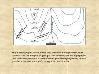
5 minutes of experiential learning: the Topographic Map Assessment As you look at each test item, ask yourself: Is it primarily about understanding elevation, or understanding the shape of the contoured surface?
Piburn et al., 2005 Role of Visualization in Learning from Computer-Based Images Evaluating computer-based modules employing simulations of topography and shallow structure ( Painted Canyon ) to present authentic geologic problems for students to solve Approximately 100 students in Introduction to Geology Quasi-experimental design Students assigned to control/experimental condition based on lab section Pre- and post-tests of spatial thinking skills (Cubes rotation and Surface development) + content assessment Key findings: Spatial skills can be improved via instruction Learning of geological content improves as a result Differences in performance between the genders can be eliminated
Titus and Horsman, 2009 Characterizing and Improving Spatial Visualization Skills Can short (5-10 minutes), weekly exercises improve students ability to visualize 3D surfaces? Structural geology course, 14 students: not a statistically significant population, so this is a qualitative study; the findings are suggestive rather than conclusive Pre- and post-tests + geological puzzles Key findings: Yes
Titus and Horsman, 2009 Characterizing and Improving Spatial Visualization Skills
Titus and Horsman, 2009 Characterizing and Improving Spatial Visualization Skills
Newcombe et al., 2015 The Lay of the Land: Sensing and Representing Topography Instrument and questions explored Study population and methods Key findings: Gestures help Pointing & tracing gestures help more than gestures representing the shape of the topography, for this population of novices Reading elevations is a different skill than reading the shape of the landscape Diectic (pointing and tracing) gestures help students understand elevations Iconic (shape) gestures help students understand the shape of the landscape
Newcombe et al., 2015 The Lay of the Land: Sensing and Representing Topography
Assessing the visualization of contoured surfaces in the geosciences Domain general We don t know of any instruments; do you? Domain specific Topographic Map Assessment (Newcombe et al.) Skill puzzles from Titus and Horsman, 2009
Implications, Strategies, and Tools for Teaching ( That s great, but how can I use it in my classroom? )
Well spend the rest of this hour in exploration Strategies for teaching about reading topographic maps: Piburn et al. s Visualizing Topography : http://reynolds.asu.edu/topo_gallery/intro_title.htm Visible Geology seems likely to have similar effect (http://app.visiblegeology.com) Diectic and iconic gestures Strategies for teaching about reading other contour maps: Titus and Horsman s structure contours puzzles especially when used with prediction coupled with immediate feedback and explanation: http://serc.carleton.edu/NAGTWorkshops/structure/SGT2012/activities/62801.html Strategies for teaching about landscape evolution through time: WILSIM: Web-based Interactive Landform Simulation shows the evolution of the Grand Canyon through time, and the user can change several parameters to explore how each affects the landscape that develops: http://serc.carleton.edu/landform/index.html Other common instructional strategies: Experiential / embodied learning: navigating a real-world landscape while using or constructing a topographic map Shaded relief maps or other modified topo maps these work, but reading a shaded relief map does not transfer to reading a regular topographic map A search of the SERC website turns up other strategies .
References Cockett, Rowan, Tara Moran, and Adam Pidlisecky (in press). Visible Geology: Creative online tools for teaching, learning, and communicating geologic concepts. Luo, Wei, Jon Pelletier, Kirk Duffin, Carol Ormand, Wei-chen Hung, David J. Shernoff, Xiaoming Zhai, Ellen Iverson, Kyle Whalley, Courtney Gallaher, and Walter Furness (2016). Advantages of computer simulation in enhancing students' learning about landform evolution: A case study using the Grand Canyon. Journal of Geoscience Education, v. 64, No. 1, pp. 60-73. Newcombe, Nora, Steven M. Weisberg, Kinnari Atit, Matthew E. Jacovina, Carol J. Ormand, and Thomas F. Shipley (2015). The Lay of the Land: Sensing and Representing Topography. The Baltic International Yearbook of Cognition, Logic, and Communication, v. 10: Perspectives on Spatial Cognition, n. 1, pp. 1-57. Piburn, Michael D., Stephen J. Reynolds, Carla McAuliffe, Debra E. Leedy, James P. Birk, and Julia Johnson (2005). The role of visualization in learning from computer- based images. International Journal of Science Education, v. 27, n. 5, pp. 513-527. Rapp, David N., Steven A. Culpepper, Kent Kirkby, and Paul Morin ((2007). Fostering Students Comprehension of Topographic Maps. Journal of Geoscience Education, v. 55, n. 1, pp. 5-16. Titus, Sarah J., and Eric Horsman (2009). Characterizing and improving spatial visualization skills. Journal of Geoscience Education, v. 57, pp. 242-254. Additional references are listed on the workshop website.