Water Scarcity Challenges in South Africa
Water scarcity is a pressing issue in South Africa, with failing infrastructure and increasing population exacerbating the problem. Learn about the consequences, impact on agriculture, healthcare, and human conflict. Explore the differences between groundwater and surface water and their respective challenges in the region.

Download Presentation

Please find below an Image/Link to download the presentation.
The content on the website is provided AS IS for your information and personal use only. It may not be sold, licensed, or shared on other websites without obtaining consent from the author.If you encounter any issues during the download, it is possible that the publisher has removed the file from their server.
You are allowed to download the files provided on this website for personal or commercial use, subject to the condition that they are used lawfully. All files are the property of their respective owners.
The content on the website is provided AS IS for your information and personal use only. It may not be sold, licensed, or shared on other websites without obtaining consent from the author.
E N D
Presentation Transcript
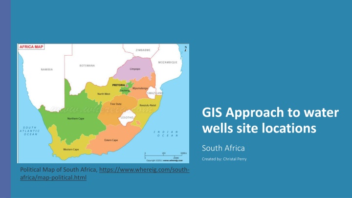
GIS Approach to water wells site locations South Africa Created by: Christal Perry Political Map of South Africa, https://www.whereig.com/south- africa/map-political.html
Water Scarce Country Water Scarcity Condition of demand for water exceeds supply and available water resources are approaching or exceeding sustainable limits Water scarcity affects 1 in 3 people in the African Region South Africa Failing water infrastructure and increasing population Approximately 35% in South Africa lacked access to safe water within this country. Most of the Africa s wells are becoming dry or surface water is polluted by human activities.
Physical and Economic Water Scarcity in Africa United Nations reported in 2011 Arid regions mainly North Africa have frequent physical water scarcity Sub-Saharan Africa have economic water scarcity Later regions have good physical water But is constrained due to poor infrastructure https://earth.org/water-scarcity-in-africa/
Consequences of Water Scarcity Agriculture will be affected Agriculture Accounts for 14% of the total Gross Domestic Product (GDP) Already heavily impacted by water scarcity Health issues Forced to get water supply from contaminated ponds and streams Widespread diarrheal diseases Cholera, typhoid fever, salmonellosis, gastrointestinal viruses, dysentery Quality healthcare services is low only 48% African people have access to healthcare Lead to Food Insecurity 70% of freshwater withdrawals go into agriculture Increased human conflict Competition between water users
Groundwater Vs Surface Water Aquifer below the earth s Surface Collects between particles, fractures, cavities inside rock layers Can be cleaner than surface water However, there is a concern of contamination from: fertilizers, septic tanks, near roadways, etc. Factors Affect volumes include: Porosity, permeability, transmissivity, recharge More accessible during periods of drought Body of water above ground Can contain high amounts of containments Easily located Water will need to be treated Requires sufficient rainfall and catchment areas https://www.watereducation.org/general-information/surface- water-vs-groundwater Groundwater Groundwater Surface Water Surface Water 5
South Africa Located at 22 degrees South to 35 degrees South and 17 degrees east to 33 degrees east. 9 Provinces (Eastern Cape, Free State, Gauteng, Kwazulu-Natal, Limpopo, Mpumalanga, Northern Cape, North West, and Western Cape) Provinces divided into metropolitan areas and district municipalities Municipalities are divided into local municipalities Local municipalities divided into wards South Africa has a subtropical climate Average annual rainfall of about 464 mm Greater elevation above sea level compared to other areas of similar latitudes. This leads to lower temperatures.
Problem Overview South Africa is a water scarce location Poor water well infrastructure There is a need to find areas for proper well locations, due to the poor well in place currently. I plan on finding groundwater potential areas in South Africa and finding suitable well location sites in those areas. https://www.gao.gov/products/gao-17-559 7
Design/Methodology/Approach GIS Based Multi-Criteria decision approach AHP (Analytic hierarchy process) Organize and analyze decisions Weights will be used along the way Ranking areas of potential ground water Areas with high ranks will be used to find potential areas for wells. https://www.researchgate.net/figure/Multi-Criteria-Decision- Analysis-MCDA-approach-using-multiple-GIS-data- for_fig7_344173326 8
Multi Criteria Decision Making (MCDM) Structure data in a way to make better informed decisions Weights will be used to rate on a scale of high to low probability of groundwater potential Thematic maps will be created with different criteria and weights will be applied
Drainage Density Map Total Length of the channels in watershed divided by the total area of the drainage watershed Higher the drainage density correlates to a lower probability to groundwater potential Created map will show areas of very low to very high density.
Lineament Density Map Lineaments are fractures or faults in the surface Have an increased permeability and porosity Map will help classify and understanding of the surface water and associated faults Will be created by using DEM layers Four different hill shades will be created to ensure lineaments will be captured from the DEM layers Azimuths 315, 200, 100, 90 Spatial Analyst tool line density will be used to help with creating the Line density map after creating the lineaments Slope Map Defined as the steepness of the ground s surface Measured from the rise over the run ArcGIS Pro will be used and slope will be created from SRTM DEM The steeper the terrain the lower the rating of the class
Land Use Land Cover Map I will be using South Africa National Land Cover Raster, reclassed to the following classes: Waterbodies Vegetation Built up Areas Agriculture Bare Lands
Soil Type Map Soil Types affects the water recharge and water holding capacity of the areas The larger the surface of the soil the more it is able to retain water and therefore will have a greater capacity to retain water Soil layer downloaded from ISRIC World Soil Information (Soil and Terrain Database for South Africa) ArcGis Portal also has a layer that was created from this data that I may look into. (ball,n.d)
Geological Map Groundwater is depended on the lithological features In South Africa there is carbonate, karst, non-carbonate, and carbonate These types of lithology will be analyzed at how permeable the type is. The weight will be classed from higher permeability to less permeable Rainfall Map Annual rainfall will relate to groundwater percentage throughout the year This map will be ranked from higher to lower percentages Layer downloaded from ESRI that was created from Nasa Global Land Data Assimilation System
Analytical Hierarchy Process (AHP) Used to organize and analyze decisions AHP is a pairwise comparison method used in criteria weighting methods Will be using the Rasterized layers that were created (Lineament Density, Land Use Land Cover, Drainage Density, Geology, Soil Type, Slope, Rain Fall Excel sheet will be used to get the percent values for the percent of influence created by Klaus Geopel This type of scale has a value of 1 9 for importance of each of the layers The excel sheet will calculate the consistency value ratio to ensure reasonability of the values
AHP Calculation All created Raster maps will be used for the AHP method Calculations will be done from the Excel spreadsheet and imported into ArcGIS Pro Weighted Overlay tool will be used The spreadsheet will give the percentage for each of the layers (how important it is to groundwater) This tool will create the groundwater potential areas Ranked from low to high probability of groundwater within the areas A field will be added to the table to calculate the areas I will use the groundwater potential map that was created to create another map for well placement areas Areas of potential contamination will be removed from the areas of groundwater potential.
Final Product Thematic map showing areas of: potential ground water Areas of potential well will be overlaid on the map https://www.cdc.gov/healthywater/drinking/public/water_sources.html 17
Conference Idea American Water Resources Association November 6 8, 2023 Raleigh NC Abstract due: May 12
Citation Lai, C. (2023, March 22). Water scarcity in Africa: Causes, effects, and solutions. Earth.Org. Retrieved April 23, 2023, from https://earth.org/water-scarcity-in-africa/ Stoll, D. (2022, October 5). Earth.ORG. Retrieved from Water Crisis in South Africa: Causes, Effects, and Solutions: https://earth.org/water-crisis-in-south-africa/ Kumari, U., & Meikap, B. C. (2021). Water scarcity is a serious problem across many nations (Mukherjee et al., 2020). Retrieved from ScienceDirect: https://www.sciencedirect.com/topics/earth-and-planetary-sciences/water-scarcity Lai, O. (2022, October 19). Water shortage: Causes and effects. Earth.Org. Retrieved April 23, 2023, from https://earth.org/causes- and-effects-of-water-shortage/ USGS science for a changing world U.S. Department of the Interior. (n.d.). Retrieved from If the ground filters water, is groundwater always clean?: https://www.usgs.gov/faqs/if-ground-filters-water-groundwater-always-clean World Atlas . (2023). Retrieved from Maps of South Africa: https://www.worldatlas.com/maps/south-africa South African Government. (2023). Retrieved from Geography and climate: https://www.gov.za/about-sa/geography-and-climate Goepel, K. (2018). IJAHP Article: Goepel/ Implementation of an online software tool for the Analytic Hierarchy. Implementation of an Online Software Tool for the Analytic Hierarchy , 10(3), 469-487. Retrieved from https://doi.org/10.13033/ijahp.v10i3.590 Melese, T., & Belay, T. (2021, October 15). Groundwater Potential Zone Mapping Using Analytical Hierarchy Process and GIS in Muga Watershed, Abay Basin, Ethiopia. Retrieved from Global Challenges: https://onlinelibrary.wiley.com/doi/full/10.1002/gch2.202100068 Prabu, P., & Rajagopalan, B. (2013, May 22). IntechOpen . Retrieved from Mapping of Lineaments for Groundwater Targeting and Sustainable Water Resource Managment in Hard Rock Hyrdogeological Envirnment Using RS-GIS: https://www.intechopen.com/chapters/44481 Mapasyst. (2019, August 21). Retrieved from What is slope, and why is it important?: https://mapasyst.extension.org/what-is- slope-and-why-is-it-important/ Ball, J. (n.d.). Noble Research Institute. Retrieved from Soil and Water relationships: https://www.noble.org/regenerative- agriculture/soil/soil-and-water-relationships/


")


")