Weather Modeling Applications in East Mediterranean Basin
This detailed overview discusses various weather modeling systems used in the East Mediterranean basin, including WRF, NMM, Eta DREAM, WAM, NMME, and more. It highlights the different nested domains, resolutions, forecast periods, compilers, and post-processing tools employed in these models. The focus is on applications like forecast charts, energy sector calculations, military research, radar reflectivity, synthetic satellite imagery, ice nuclei estimation, and frontogenetic parameter determination.

Download Presentation

Please find below an Image/Link to download the presentation.
The content on the website is provided AS IS for your information and personal use only. It may not be sold, licensed, or shared on other websites without obtaining consent from the author.If you encounter any issues during the download, it is possible that the publisher has removed the file from their server.
You are allowed to download the files provided on this website for personal or commercial use, subject to the condition that they are used lawfully. All files are the property of their respective owners.
The content on the website is provided AS IS for your information and personal use only. It may not be sold, licensed, or shared on other websites without obtaining consent from the author.
E N D
Presentation Transcript
Model: WRF (ARW Core) - East Mediterranean basin in 3 nested domains (with 2-way feedback) at 18km, 6km and 2km horizontal resolution and 60 vertical (eta) levels. Forecast period = 120 hours, initialized for 00 and 12UTC from GFS (3hr data ingestion interval). Model compiled using the Intel C/Fortran compiler suite. WRF-NMM: 4 km - once a day, for the next 96 h, pgi compiler. NMMB model 6 km, ifort, fort the next 96 h. Eta DREAM - operational, first version h.r about 30 km , Mediterranean+N.Afrika 120h forecast WAM, 1.0 Mediterranean , h.r 0.25 degree East Mediterranean , h.r. 0.125 degree Adriatic h.r. 0.0625 degree 144h forecast WRF NMM the latest version v4.1.1 from Mediterranean to 1/2 Montenegro from 12km to 0.5km h.r resolution 144 to 120 h forecast pgi, gfortran , intel research: Eta_Slop, workstation_all, NMM-E HIres, WRF-ARW, WRF-NMM, NMMB in process to building. NMME_v3.9.1 - running daily on a computer in our premises, however we have external help for any programming issues including maintenance of the system and solving any kind of problems connected to the model WRF-ARW - model with three nested domains for the Eastern Meriterranean, the Cyprus FIR and focusing on Cyprus at 2km (18km,6km,2km.) We use the gnu compilers and NCL for post processing NMMB Global - Global, resolution 30km, 10 days forecast, initial conditions GFS NCEP, start at 00UTC NMMB12 Regional (Mediterranean, Europe and East Atlantic), resoultion 12km, 5 days forecast, boundary conditions from NMMB global, start at 00 and 12 UTC NMMB4 NMMB nested in NMMB12 km - regional (Balkan region), resolution 4km, 3 days forecast, start at 00 and 12 UTC NMMBEC NMMB - BC from IFS ECMWF (9km) operational on CRAY, regional (Mediterranean, Europe and East Atlantic), horizontal resolution is about 4 km, 3 days forecast, start 00 UTC ECNMM WRF-NMM v3.5.1 with BC from IFS ECMWF, regional (Balkan region), horizontal resolution is about 4 km, 3 days forecast , boundary conditions DWD and GFS, start 00 UTC ETA - regional (Mediterranean, Europe and East Atlantic), 26 km resolution, 5 days forecast, DWD boundary conditions, start 00 and 12 UTC NMME-DREAM8 - Dust Regional Atmospheric Model with 8 categories for dust particle sizes (DREAM8) embedded in NCEP Nonhydrostatic Mesoscale Model on E-grid (NCEP/NMME), operational version resolution 25 km, fully dynamic dust transport model, start 00 UTC, assimilation of ECMWF dust analysis, 3 days forecast, region (East Atlantic, Europe, Africa, and Middle east) NMME-DREAM8 - regional model, for testing purposes, horizontal resolution from 15 to 3.5 km NMME-DREAM-ICELAND - regional operational model for high latitude dust sources and transport, resolution 7.5 km, 3 days forecast GLOBAL NMMB-DREAM - resolution 25 km, will be operational soon
11. Please list the developed added value applications. 5 responses Basic forecast charts for use in weather forecasting operations Specialized point-value calculations for the energy sector (renewable energy sources) Military-oriented applications and special products for research institutions. Composite radar reflectivity Synthetic satellite imagery (IR 10.8 and WV 6.2 channel) Number of ice nuclei due to the mineral dust aerosol (3D field) Frontogenetic parameter
13. Please list the NMMB model output parameters needed as initial and lateral boundary conditions for running your regional model.4 responses No NMMB model output parameters are being used. Our model makes use of most of the GFS output variables for all levels. We download boundary conditions fron NCAR so in few words, whatever exists in those files None
20/10/2018 in Platania (3456'N, 3255' E), Farmakas ( (3455' N, 3308' E) 4-6/12/2018 Paphos Airport (34 43'3.59" N 32 29'3.59" E), Asprogremos , Paralimni (35 0' 7.07'' N and 34 2' 50.38'' E) 15-16/01/2019 Platania (34 56'N, 32 55' E) 12-13/06/2019 Kyperounta (34 56'N, 32 58' E) 13-17.05.2014., high intensive precipitations specially at northeast part of the country. 14.05.2014., Tuzla 95 mm, 15.05.2014. Tuzla 90 etc from 13-18 .08.18 it was heavy precipitation in Kyiv region Date 24.05.2012., It lasted around 10 hours, around 8 hours over Republic of Srpska. 10/10/2015 Cyclonic activity with heavy precipitation (80 to 100 mm for 24 hour period) for the whole country - 06/08/2016 Mesoscale convective system with intensive rain for short period of time (around 90 mm for 3 hours, most severe from 16 to 18 UTC) causing flash flood with great material damage and human victims in the vicinity of Skopje - 16/05/2017 Thunderstorms with heavy rain (32 mm for 1 hour, from 10:30 to 11:30 UTC), strong wind and hail in the vicinity of Kumanovo (north-eastern part of the country) - 10/07/2019 Thunderstorms with devastating wind gusts in south-western part of the country (connected with the severe weather registered in Greece) 13.-18. may 2014. 2.-4. June 2019. 24. June 2019
2. Which data (for the above listed situations) you would be ready to provide (kind of data such as observed or remote sensed, radar data, automatic precipitation stations, parameter name, quality controlled or not, data time period and frequency, any other relevant data)? 8 responses RADAR data (5-10 minute intervals, approximately), automatic weather station measurements (max freq. 10 minute interval). observed, remote sanded, every hour at least Daily observations from the surface network ground station We would provide every type data that we have for the situation mentioned this qualite controlled data 24 hours preciptation Observed precipitation amounts and other parameters (wind) from classical weather stations, data from automated stations for some of the cases, some radar data, data from rain-gauge stations. Data from analog and automatic stations. We cannot currently provide rainfall from the radar network, i expect this to happen soon Observed parameters (precipitation, temperature, wind etc.) from GMS station network, precipitation from rain- gauge stations, automatic weather station data, radar data
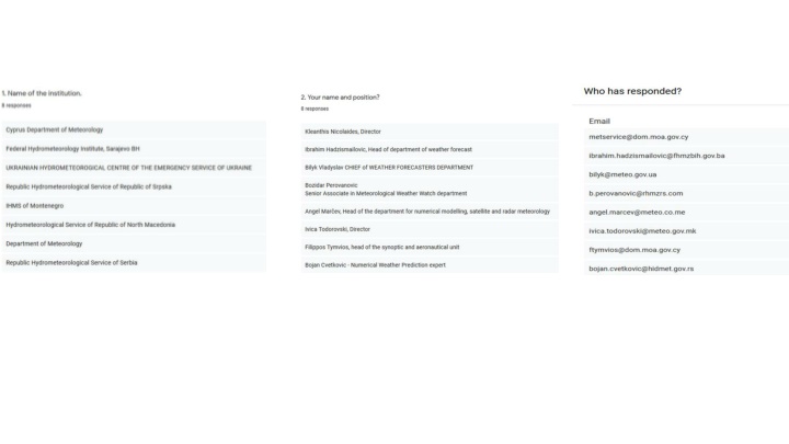
6. If you have experienced person within your institution, with practical knowledge in NWP model verification, please specify his/her name and position. The proposed candidate will be asked to be fully involved in NMMB verification process as a member of the WG.7 responses We do not carry out model veritication due to limited resources. None Angel Mar ev, head of the department for numerical modeling, satelite and radar meteorology Kostadinka Arsovska Demetris Charalambous, head of the IT section of the department Bojan Cvetkovic Numerical Weather Prediction expert
 - East Mediterranean basin in 3 nested")
 - East Mediterranean basin in 3 nested")
 - East Mediterranean basin in 3 nested")
 - East Mediterranean basin in 3 nested")
 - East Mediterranean basin in 3 nested")


, Farmakas (")
 you would be")
 you would be")
 you would be")