Design Changes and Innovations in ScaleMaster Multiscale Design Decisions
Explore the various categories of design change, new terrain recommendations, road thinning projects, and ongoing research initiatives in the field of cartography and geographic information systems. Discover what's not yet included in ScaleMaster and the data development needs for enhancing geographic databases, all discussed in a comprehensive manner.

Download Presentation

Please find below an Image/Link to download the presentation.
The content on the website is provided AS IS for your information and personal use only. It may not be sold, licensed, or shared on other websites without obtaining consent from the author. If you encounter any issues during the download, it is possible that the publisher has removed the file from their server.
You are allowed to download the files provided on this website for personal or commercial use, subject to the condition that they are used lawfully. All files are the property of their respective owners.
The content on the website is provided AS IS for your information and personal use only. It may not be sold, licensed, or shared on other websites without obtaining consent from the author.
E N D
Presentation Transcript
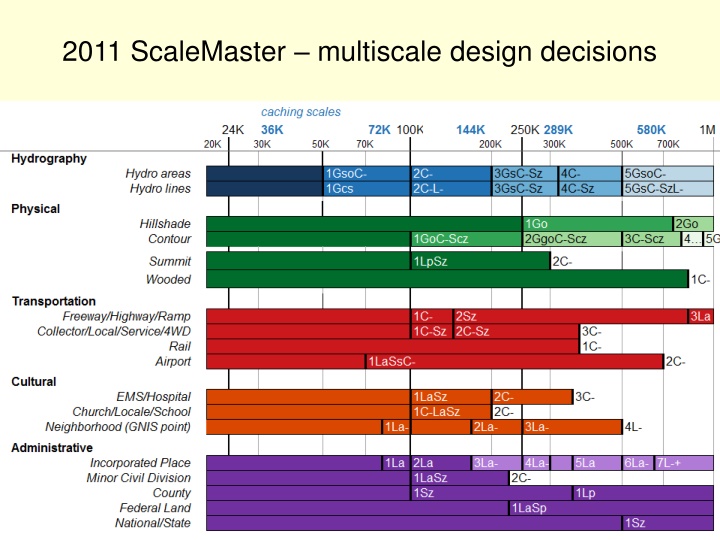
Categories of design change Content Add Features (C+) Eliminate Features (C-) Reclassify Features (Cc) Reorder Features (Co) Geometry Aggregate (Gg) Collapse (Gc) Displace (Gd) Exaggerate (Gx) Merge (Gm) Simplify (Gs) Smooth (Go) Symbol Adjust Color (Sc) Enhance (Se) Adjust Pattern (Sp) Rotate (So) Adjust Shape (Ss) Adjust Size (Sz) Adjust Transparency (St) Typify (Sf) Labeling Add Labels (L+) Eliminate Labels (L-) Adjust Appearance (La) Adjust Position (Lp) GC replace with generalized dataset Roth et al., 2011, Cartographic Perspectives CEGIS, June 2011 C. Brewer
In Progress New terrain recommendations from Andy Stauffer CEGIS, June 2011 C. Brewer
In Progress Road thinning from Larry+, TeleAtlas or TIGER? CEGIS, June 2011 C. Brewer
In Progress Airport shape database--IDs, join to FAA data on flight numbers Need rail hierarchy CEGIS, June 2011 C. Brewer
In Progress Need hierarchy on GNIS points, structures (17 types) CEGIS, June 2011 C. Brewer
In Progress Ongoing placename hierarchy research (TNM UC, ICA Workshop) CEGIS, June 2011 C. Brewer
In Progress Landcover resolution, overlay with admin CEGIS, June 2011 C. Brewer
Whats not in ScaleMaster yet Ortho imagery through scale Grids, coordinates, PLSS through scale Coordinate land cover and related admin boundaries Wooded and forest reserves Built up areas and incorporated place boundaries, CDPs CEGIS, June 2011 C. Brewer
Data development needs from others Areas for GNIS point names: physical features (bay, valley ), building complexes (large hospital, campus ) More hierarchies Roads Structures (for 17 types in standard) Airports Rail Summits (importance vs elevation threshold or relief analysis) To> CEGIS, June 2011 C. Brewer


![❤[READ]❤ Deep Space Craft: An Overview of Interplanetary Flight (Springer Praxis](/thumb/21511/read-deep-space-craft-an-overview-of-interplanetary-flight-springer-praxis.jpg)