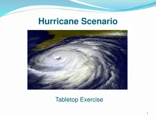
Hurricane Formation
Ocean and atmosphere systems interact to create hurricanes, powered by latent heat stored in water vapor. Learn about hurricane characteristics, formation conditions, and the impact as they approach land, supported by a collaboration between NSF Directorates.

Download Presentation

Please find below an Image/Link to download the presentation.
The content on the website is provided AS IS for your information and personal use only. It may not be sold, licensed, or shared on other websites without obtaining consent from the author.If you encounter any issues during the download, it is possible that the publisher has removed the file from their server.
You are allowed to download the files provided on this website for personal or commercial use, subject to the condition that they are used lawfully. All files are the property of their respective owners.
The content on the website is provided AS IS for your information and personal use only. It may not be sold, licensed, or shared on other websites without obtaining consent from the author.
E N D
Presentation Transcript
Hurricane Formation: Ocean and Atmosphere Systems Interact to Create Hurricanes This work is supported by a National Science Foundation (NSF) collaboration between the Directorates for Education and Human Resources (EHR) and Geociences (GEO) under grant DUE - 1125331
Questions What is a hurricane? What four conditions are necessary for hurricane formation? What happens as hurricanes approach land?
What is a Hurricane? Make a list of hurricane characteristics:
What is a Hurricane? Formal definition: An intense low pressure system with sustained winds >74 mph
What Makes a Hurricane? Four essential ingredients
What Makes a Hurricane? 1) Warm SST >26.5 C (80 F) over large area
What Makes a Hurricane? 1) Warm SST (>26.5 C) over large area 2) Instability in atmosphere (rising air mass, beneath which surface winds converge)
What Makes a Hurricane? 1) Warm SST (>26.5 C) over large area 2) Instability in atmosphere (rising air mass) 3) Little/no vertical wind shear through atmosphere to tropopause (tropopause) Which wind profile has too much vertical shear for hurricanes to form? (atmosphere) (ocean)
What Makes a Hurricane? 1) Warm SST (>26.5 C) over large area 2) Instability in atmosphere (rising air mass) 3) Little/no vertical wind shear through troposphere 4) Sufficient latitude >5-10o off equator
Hurricanes are powered by: latent heat stored in water vapor released when water condenses 1. Warm water supplies sensible heat and humidity to overlying air 2. Air decreases density; rises 3. Air cools; H2Ovapor condenses 4. Latent heat released -- Heat warms air; rises faster 5. P gradient increases -- Faster winds converge at the low pressure center -- More water vapor into system! Feedback between the ocean and atmosphere systems!
Can Hurricanes Cross the Equator? Discuss with the person next to you. Why or why not?
Can Hurricanes Cross the Equator? Discuss with the person next to you. Why or why not? (Hurricane tracks 1985-2005; NASA)
North Atlantic Hurricane Season is June-November Most storms occur in which month? 4 3.5 Tropical Storms Hurricanes Hurricanes w/US Landfall Average number per month, 1851- 3 2.5 2 1.5 2011 1 0.5 0
Which of these things would cause a hurricane to lose energy? a) Moving over colder water b) Moving over warmer water c) Making landfall d) Crossing the ocean
Wind and Rain (NOAA)
Storm Surge (NASA)
As hurricanes make landfall, they decrease in strength Why? Remember what fuels hurricanes Warm water!
Draw: The relationships between the ocean, atmosphere, and people in a hurricane. Make sure you can now answer these: What is a hurricane? - What four conditions are necessary for hurricane formation? - What happens as hurricanes approach land?
References Slides 4 and 5. Public Domain Image of Hurricane Rita as a Category 5 hurricane. http://www.nnvl.noaa.gov/hurseas2005/Rita2045zD-050921-1kg12.jpg Slide 6. Public Domain Image of SST. http://www.osdpd.noaa.gov/data/sst/fields/FS_km10000.gif Slide 7. Public Domain illustration of tropical waves. http://www.aoml.noaa.gov/hrd/tcfaq/Twaves.jpg Slide 9. Creative Commons illustration of hurricane forces: http://en.wikipedia.org/wiki/File:Hurricane_isabel_and_coriolis_force.jpg Slide 12. Public Domain image of hurricane tracks: http://www.nasa.gov/images/content/313775main_global_hurr_tracks_HI.jpg Slide 15. Public Domain image of Hurricane Eloise approaching shore.http://www.photolib.noaa.gov/historic/nws/images/big/wea00416.jpg Slide 17. Public Domain illustration of storm surge.http://earthobservatory.nasa.gov/Library/Hurricanes/Images/storm_surge.gif Slide 18. Public Domain image of 2012 hurricane tracks. http://www.nhc.noaa.gov/2012atlan.shtml All other illustrations and text were created by Lisa Gilbert under a Creative Commons Attribution-NonCommercial- ShareAlike license http://creativecommons.org/licenses/by-nc-sa/3.0/ You may reuse this item for non-commercial purposes as long as you provide attribution and offer any derivative works under a similar license.