Lightning Mapper and Rapid Intensification Index
Learn about the Geostationary Lightning Mapper (GLM) and Lightning-Based Tropical Cyclone Rapid Intensification Index, including their detection capabilities and use in forecasting severe weather events like tropical cyclones. Access images, data samples, and product information related to lightning strikes and storm intensity changes.

Download Presentation

Please find below an Image/Link to download the presentation.
The content on the website is provided AS IS for your information and personal use only. It may not be sold, licensed, or shared on other websites without obtaining consent from the author. If you encounter any issues during the download, it is possible that the publisher has removed the file from their server.
You are allowed to download the files provided on this website for personal or commercial use, subject to the condition that they are used lawfully. All files are the property of their respective owners.
The content on the website is provided AS IS for your information and personal use only. It may not be sold, licensed, or shared on other websites without obtaining consent from the author.
E N D
Presentation Transcript
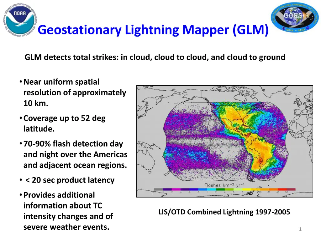
Geostationary Lightning Mapper (GLM) GLM detects total strikes: in cloud, cloud to cloud, and cloud to ground Near uniform spatial resolution of approximately 10 km. Coverage up to 52 deg latitude. 70-90% flash detection day and night over the Americas and adjacent ocean regions. < 20 sec product latency Provides additional information about TC intensity changes and of severe weather events. LIS/OTD Combined Lightning 1997-2005 1
2011 NHC Proving Ground Products Rapid Intensification Index (RII) Mark DeMaria / John Knaff 2
Lightning-Based Tropical Cyclone Rapid Intensification Index (RII) Ground-based lightning data used as a proxy for GOES-R GLM NHC real-time rapid intensification index (RII) Input from GFS model, GOES imagery, oceanic heat content analyses, Reynolds SST, persistence Discriminant analysis provides probability of max wind increase of at least 30 kt in 24 hr Experimental version adds lightning density input 6 hr storm-relative composites 2005-2010 developmental sample from WWLLN Real time in 2011 from WWLLN feed at CIRA Last year Vaisala used in real time, which introduced additional source of error Text product distributed from CIRA Analogous to text product for operational RII 3
6 hour WWLLN Lightning Strikes -- Hurricane Omar 16 Oct 2008 RII predictors include inner core (0-100 km) and rainband (200-300 km) lightning strike density 4
Sample Text Output from 2010 product Lightning-Based Rapid Intensification Forecast Algorithm Hurricane Alex 30 June 2010 00 UTC Will be available at:ftp://rammftp.cira.colostate.edu/demaria/NHCPG 5
Summary of 2011 RII Changes WWLLN used in real time, consistent with developmental sample Output will also include rapid weakening probability Max wind decrease of 20 kt or more in 24 hr Valid for storms over water
")