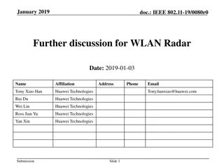
Potential of WIVERN W-Band Doppler Radar for Cyclone Analysis
WIVERN W-band polarization diversity Doppler radar is a cutting-edge technology used to investigate internal structures of Mediterranean cyclones. This radar system provides valuable insights into cyclone development, wind profiles, and atmospheric conditions, enhancing forecasting accuracy and early detection capabilities.

Download Presentation

Please find below an Image/Link to download the presentation.
The content on the website is provided AS IS for your information and personal use only. It may not be sold, licensed, or shared on other websites without obtaining consent from the author.If you encounter any issues during the download, it is possible that the publisher has removed the file from their server.
You are allowed to download the files provided on this website for personal or commercial use, subject to the condition that they are used lawfully. All files are the property of their respective owners.
The content on the website is provided AS IS for your information and personal use only. It may not be sold, licensed, or shared on other websites without obtaining consent from the author.
E N D
Presentation Transcript
The potential of the WIVERN W-band polarization diversity Doppler radar for looking into the internal structures of Mediterranean cyclones A. Battaglia, F. Tridon, A. Parodi, M. Lagasio, V. Mazzarella, and A. Illingworth
WIVERN radar: ESA Earth Explorer 11 candidate W-band (94 GHz, transmitter similar to CloudSat) Doppler (polarization diversity) conically scanning at 41 degrees big antenna ( 3dB 0.07o) Wolde et al., AMT 2018 Battaglia et al, AMT, 2018 Illingworth et al., BAMS, 2018. Battaglia et al, IEEE TGRS, 2017 Battaglia et al, JTech, 2015 SCIENCE QUESTIONS First mission to acquire line-of- sight wind profiles in clouds on a global scale. Its near-real-time observations with precision better than 2 m/s will improve NWP via monitoring of the vertical structure of winds and by capturing early stages of cyclogenesis. At what heights will we have a meaningful Can WIVERN see inside tropical cyclones and medicanes? www.wivern.polito.it Wivern complement in mid-troposphere cloudy areas observations from aircrafts, scatterometers, ADM-AEOLUS, and cloud motion winds from sequential geo images. Currently in Phase-0 as part of the ESA Earth Explorer 11 program. number of winds? 2
Wivern E2E simulator Battaglia et al., AMT 2022 Key tool during Phase 0 study. Meteo France is studying impact of LOS wind assimilation via an Ensemble Data Assimilation (EDA) with the ARPEGE model 3
Example: Medicane Apollo 29/10/2021 Powerful Mediterranean tropical-like cyclone that affected many countries on the Mediterranean coast, especially the island of Sicily Developed from an area of organized thunderstorms over the Balearic Islands, Apollo reached its peak intensity when passing close to Sicily Max winds of 100 km/h, 7 fatalities, more than 200 million $ of damage High resolution WRF simulation: analysis on the 29/10, the day of peak intensity 4
E2E simulator of WIVERN through the WRF output Trajectory of the satellite Simulation at 333 m horizontal resolution of: an overpass of Apollo by WIVERN the scanning through the Medicane in forward view observed reflectivity and Doppler velocity Boresight position at the surface 5
Totat Water Content in the line of sight and corresponding Z WIVERN is able to sample most of the Medicane The whole ice part is useful The signal is fully attenuated only in narrow deep convective cores 6
Simulated Vd and Vd errors Most of wind errors happen near strong Z gradients (cloud tops and melting layer) Errors are mainly driven by SNR: if 3 dB above detection typically we reach target precision. There are issues in region of strong non uniform beam filling (on going studies) 7
The Tropical Cyclone CloudSat dataset: the full year 2007 CloudSat data within 1000 km of Tropical Cyclone centres Year 2007: 1250 CloudSat overpasses of 89 different tropical cyclones 1000 km All data Unsaturated data 8
Example on hurricane ZITA (19 Jan 2007) CloudSat observations Wivern simulation Battaglia et al., AMT 2018 Reflectivity curtain from 2B-GEOPROF Attenuation estimate from 2C-RAIN- PROFILE (+ iterative correction up to 6 dB where surface is not visible) 9
Example on hurricane ZITA (19 Jan 2007) CloudSat observations Reflectivity curtain from 2B-GEOPROF Zeff Attenuation estimate from 2C-RAIN- PROFILE (+ iterative correction up to 6 dB where surface is not visible) 10
Example on hurricane ZITA (19 Jan 2007) WIVERN simulation WIVERN reflectivity curtain with no data where attenuation is unknown Doppler velocity residuals after correcting for non uniform beam filling and wind shear biases 11
Statistical results Results (without ghosts) Indicative of radar sensitivity Below 11 km, WIVERN will measure at least 60% of the winds with an accuracy better than 2 m/s (better with increasing sensitivity) The fraction of wind observations will peak between 8 and 10 km height Below 9 km, WIVERN will detect at least 70% of the clouds (better with increasing sensitivity) Only 10% of clouds detection is lost due to too strongly attenuated profiles 12
How many precise winds measurements? Wivern will produce precise winds on roughly half of the pixels seen by CloudSat Wivern will map cyclones with a sampling >70 times better than CloudSat 1000 km for Tropical Cyclone overpasses WIVERN WINDS= 35 X CLOUDSAT OBSERVATIONS Over a year (1250 CloudSat overpasses in 2007 1,754,784 km so if we assume 20 layers of 500 m with a 20% cloud cover this implies that Wivern will measures 245 millions precise winds in Tropical Cyclones 13
Conclusions WIVERN is an EE11 candidate mission, now in Phase 0 (downselection to 2 at the end of 2023, launch in 2030). Cutting-edge radar instrument: first-ever conically scanning W-band radar with Doppler implemented via polarization diversity. Flagship product: in-cloud vertical profiles of winds over a large swath of winds are expected also in cyclonic systems and medicanes with a peak of occurrences at 10 km. plenty How to use these data? WIVERN measurements will be used for DA in global models (Ensemble DA studies just started at Meteo France). In Medicanes they will provide unique information about the dynamical structure of the cyclones. More studies are needed in order to assess the relevance of these observations in DA for regional models active collaboration with the modelling community highly desirable! contact: alessandro_battaglia@polito.it


")
")
")